The 24 August 2000 Landslide near 2B Bowen Road, Mid-Levels
Basic Data
Material:
Fill
Feature Affected:
Unregistered Fill Slope
Volume:
120 m3
Report Reference:
GEO Report No. 131
Description
The landslide occurred in unregistered, old, loose fill deposited on a steeply-sloping terrain during heavy rainfall (return period of 50 years). Landslide debris entered into an adjacent nullah and was transported downstream to reach Hong Kong Park some 250 m away. One lane of Kennedy Road was blocked temporarily by the landslide debris. No casualties were reported.
The landslide occurred partly within the green hatched-black (GHB) area of a residential redevelopment. The stability of the western GHB area was assessed during the redevelopment of the adjacent lot in October 1995. The fill material within the GHB area, which was deposited between 1949 and 1967, had not been identified by SIFT and was not considered during the geotechnical assessment for the residential redevelopment project.
The landslide was probably caused by the build-up of transient perched water pressure in the fill following severe rainfall.
Concentrated surface runoff originating from the poorly detailed surface drainage provisions above the landslide site, which was exacerbated by blockage of the channels, was likely to have been an important source of water ingress at the landslide site.
Observations
This landslide shows the potential hazard of instability associated with unidentified fill bodies. It also highlights the importance of good detailing and proper maintenance of surface drainage system on slopes.
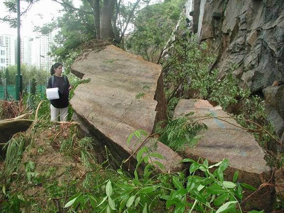
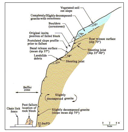
The 3 August 2000 Rockfall from Slope No. 11NE-D/C45, Hiu Ming Street, Kwun Tong
Basic Data
Material:
Slightly to Moderately Decomposed Granite
Feature Affected:
Rock Cut Slope No.11NE-D/C45
Volume:
15 m3 rock blocks
Report Reference:
GEO Report No. 130
Description
A rock block (about 3 m by 2 m by 2 m) detached from a rock cut slope above Hiu Ming Street playground during moderate rainfall. The block fell about 20 m and came to rest within a buffer zone located at the toe of the slope. Prior to this failure, a number of minor rockfalls had occurred on the slope between 1986 and 1993 and a major failure (200 m3 in volume) occurred on the slope in 1993. As a buffer zone was provided in front of the slope and fortuitously, these incidents had not caused any casualties.
The 2000 rockfall was probably caused by built-up of transient cleft water pressure within an adversely orientated, wavy, undulating and partly open sheeting joint. Progressive deterioration of the slope in respect of the development of open, partly clay-infilled joints allowing enhanced water ingress, together with tree root action of unplanned vegetation are key contributory factors to the rockfall.
Observations
The wavy nature of the sheeting joints that gave rise to local adverse steepening, as measured on the basal slip surfaces of the 1993 and 2000 failures, is not readily apparent from the linear traces observed in the rock face.
The incident highlights the importance of appropriate characterisation of potentially adverse and wavy joints in rock slope stability assessment and regular inspections and maintenance to prevent slope deterioration.
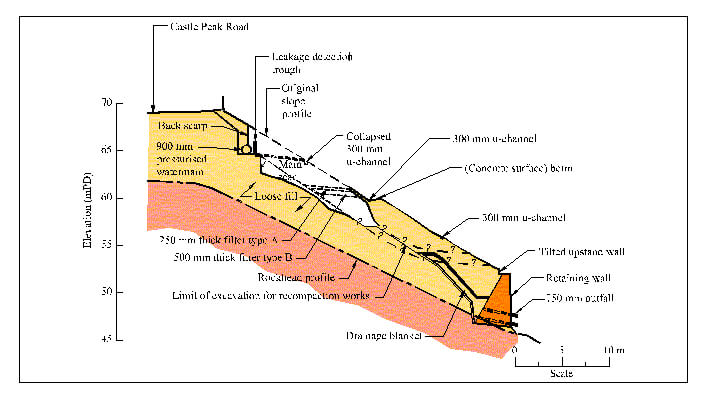
The Landslide on Fill Slope No. 11NW-A/FR84 below Castle Peak Road, Kau Wah Keng Village, Kwai Chung
Basic Data
Material:
Fill
Feature Affected:
Fill Slope No 11NW-A/FR84
Volume:
700 m3
Report Reference:
GEO Report No. 123
Description
Major internal erosion and severe distress at slope No. 11NW-A/FR84 was reported to the GEO in January 2000. The slope was previously upgraded under the LPM Programme in 1982. The instability was probably caused by prolonged leakage from a 900 mm diameter pressurised watermain that was encased in a concrete trough which formed part of the leakage detection system constructed as part of the LPM works.
The effects of leakage from the watermain were exacerbated by the presence of a 150 mm diameter hole at the bottom of the concrete trough. Poor detailing of the concrete trough (i.e. inadequate connection details between the overflow pipe and the outlet in the trough) probably also played a role in the failure by allowing additional concentrated water ingress into the fill slope following dislocation of the connection.
An Engineer Inspection report in 1995 for this slope did not make any reference to the presence of the leakage detection system for the 900 mm diameter pressurised watermain.
Notable discharge (leading from the leakage detection system) was observed during a Routine Maintenance Inspection in November 1996. No records were found to indicate that the recommended follow-up action (i.e. more detailed investigation through an Engineer Inspection) was carried out prior to the 2000 incident.
Observations
This incident highlights the need for proper documentation of special features relating to water-carrying services in maintenance manual and to ensure that both maintenance departments and departments with facilities within or supported on the slope are fully aware of all matters relevant to the future maintenance of the slope and their facilities. Therefore, regular monitoring of the special features can be carried out and prompt action can be taken.
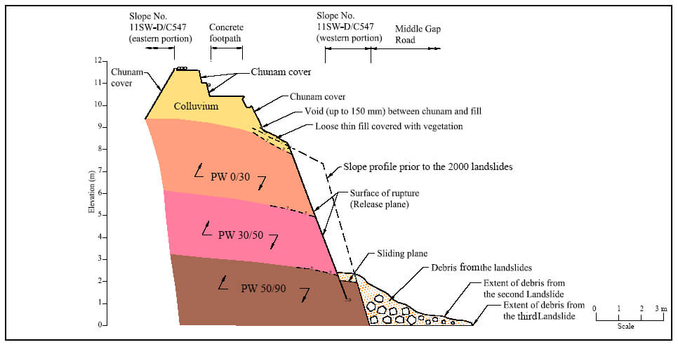
The 17 and 19 July 2000 Landslides on Slope No. 11SW-D/C547 at Middle Gap Road, Wai Chai Gap
Basic Data
Material:
Colluvium / Decomposed Tuff
Feature Affected:
Cut Slope No. 11SW-D/C547
Volume:
about 23 m3 (Total)
Report Reference:
Review of the July 2000 Landslides on Slope No. 11SW-D/C547 at Middle Gap Road
Description
Three landslides (debris volume 0.4 m3, 5 m3 and 18 m3 respectively) occurred within 3 days on a soil/rock cut slope where roadworks were being carried out along the slope toe. The time gap between the occurrences of the second and the third landslides was less than five hours. The debris of the second and third landslides were deposited on Middle Gap Road and resulted in temporary closure of one lane. No casualties were reported.
The slope has a history of failures (including a 40 m3 failure in 1992). The key contributory factors to the July 2000 landslides were the presence of adverse-orientated, highly persistent discontinuities with weak infill which had opened up through progressive slope deterioration, and root action of unplanned vegetation.
The failure was triggered by rainfall from a moderate storm (return period less than 2 year) as surface runoff entering open discontinuities in the slope leading to the build-up of transient cleft water pressure. The excavation of a shallow trench immediately below the slope with the use of a pneumatic hammer was in progress at the time of the second landslide. Given the relative timing of the works and the landslide, the possibility of vibrations generated by the hammering action being a contributory factor to the subsequent failure cannot be ruled out.
Observations
This series of landslides highlights the potential hazard of unplanned vegetation and inadequate maintenance on slopes with adverse geological features and past instability.
It also highlights the importance of a thorough inspection of the area in the vicinity of the failure to check for signs of distress and possible presence of marginally stable material that may not have fully detached.
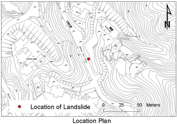
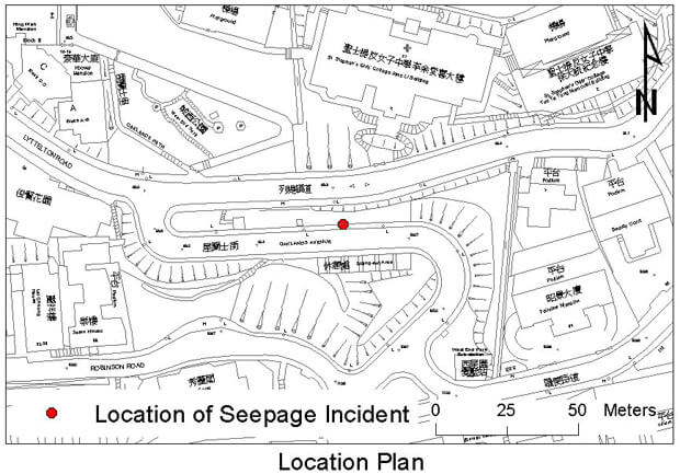
The 18 June 2000 Seepage Incident at Feature No. 11SW-A/R625 and Ground Subsidence behind Slope No. 11SW-A/FR12 near Oaklands Avenue, Mid-levels
Basic Data
Material:
Fill
Feature Affected:
Slope No. 11SW-A/FR12 and Retaining Wall No. 11SW-AR625
Volume:
Not applicable
Report Reference:
GEO Report No. 131
Description
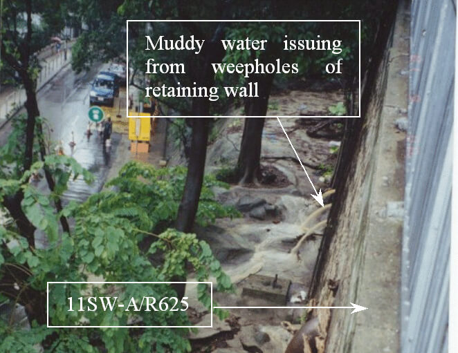
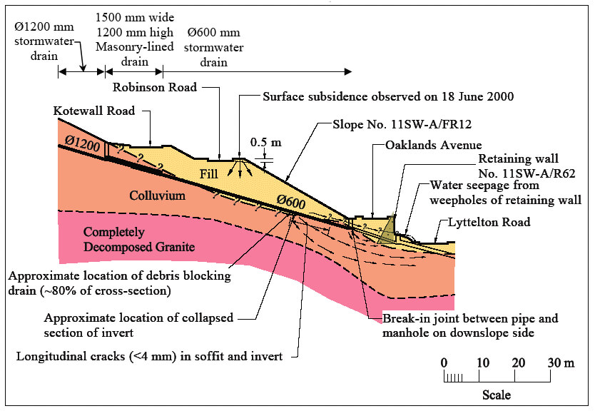
The incident involved significant leakage from a defective stormwater drain underneath fill slope No. 11SW-A/FR12 (between Robinson Road and Oaklands Avenue), leading to subsurface erosion of the fill slope and ground subsidence behind the slope crest as well as strong outflow of muddy water from the weepholes of retaining wall No. 11SW-A/R625 (between Oaklands Avenue and Lyttelton Road). As a result of the incident, both lanes of Oaklands Avenue and the westbound lane of Lyttelton Road were temporarily closed.
The stormwater drain received the flow from the Po Shan Stream and varied from 600 mm to 1200 mm in size. The portion of the defective drain was constructed in the mid-1960's.
CCTV surveys of the 600 mm stormwater drain carried out following the incident revealed that defects (collapsed invert and break at a joint) were located in the section of the drain underneath slope No. 11SW-A/FR12 and at the connection to a manhole at Oaklands Avenue. Seepage water from the broken drain was probably directed to the back of retaining wall No. 11SW-A/R625 along a network of erosion pipes within the colluvium and resulted in outflow of muddy water from the weepholes.
Observations
The incident highlights the potential hazard of water leakage from major water-carrying services underneath slopes, and serves as a reminder of the need for proper engineering input for the inspection and maintenance of water-carrying services adjacent to, as well as traversing across, slopes.
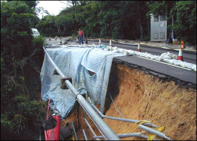
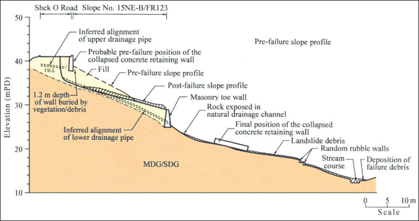
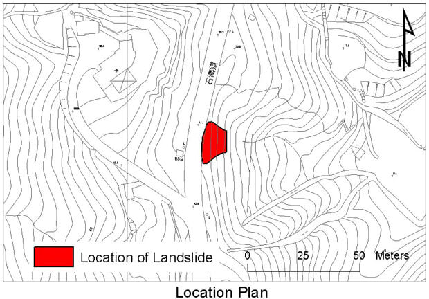
The 24 August 2000 Landslide on Fill Slope below Shek O Road, Shek O
Basic Data
Material:
Fill
Feature Affected:
Fill Slope No. 15NE-B/FR123
Volume:
300 m3 of fill including a crest concrete retaining wall
Report Reference:
GEO Report No. 130
Description
The 300 m3 landslide occurred on a pre-1977 loose fill slope (No. 15NE-D/FR123) which crossed a natural drainage line at the landslide location. The landslide caused temporary closure of Shek O Road, thus, cutting off the sole access to Shek O Village and Big Wave Bay. An unoccupied taxi fell into the landslide scar. The landslide debris travelled downslope into a stream course and its outwash was subsequently deposited onto the golf course of the Shek O Country Club. No casualties were reported.
The rainstorm triggering the failure was particularly severe with almost 330 mm of rainfall recorded in the 4 hours prior to the failure (return period of about 250 years). The landslide probably involved liquefaction of loose fill below a 3.6 m high concrete retaining wall at the slope crest. Apart from direct infiltration through vegetated slope surface and the slope surface where the hard cover became dilapidated, other sources of water ingress into the loose fill possibly included leakage from broken cross-road drains which ran through the slope, leakage from cable conduits with friction fit joints which ran along the slope crest and sub‑surface seepage through the loose fill material.
The crest concrete retaining wall, which was probably built as part of the urgent repair works following a landslide in 1979, appeared to have been constructed on a loosely compacted fill slope across a natural drainage line. An Engineer Inspection carried out in September 1999 did not identify the presence of the crest wall and poor conditions of the hard slope cover in front of the wall.
Observations
Particular attention is drawn to the importance of a thorough Engineer Inspection of a slope. Any discrepancies between records and site conditions should be followed up. This incident also highlights the potential hazard of fill slopes with inadequate compaction and the importance of proper maintenance of water-carrying services adjacent to slopes.
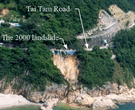
The 24 August 2000 Landslide at the Hillside below Tai Tam Road, Tai Tam
Basic Data
Material:
Decomposed Tuff
Feature Affected:
Natural Terrain
Volume:
700 m3
Report Reference:
Review of the 24 August 2000 Landslide at the Hillside below Tai Tam Road
Description
The massive landslide occurred on the natural hillside below Tai Tam Road after heavy rainfall. As a result of the landslide, the westbound lane of Tai Tam Road was temporarily closed. No casualties were reported.
The landslide involved a structure-controlled failure associated with adverse geological features including persistent planar discontinuities. The failure was probably caused by the transient build-up of groundwater pressure. Concentrated discharge of surface runoff from the cross-road stormwater drain directly onto the hillside below, causing gradual deterioration of the marginally stable hillside, together with the presence of adversely orientated discontinuities were probably the major factors in the failure. Overspilling of surface runoff from Tai Tam Road could have provided further source of water ingress in the source area of this landslide.
Observations
This incident highlights the need to pay particular attention to the outfall details of stormwater drains discharging directly onto hillsides below roads.
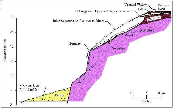
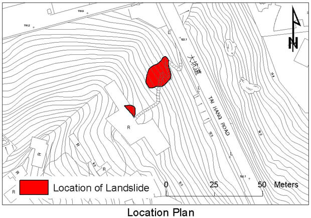
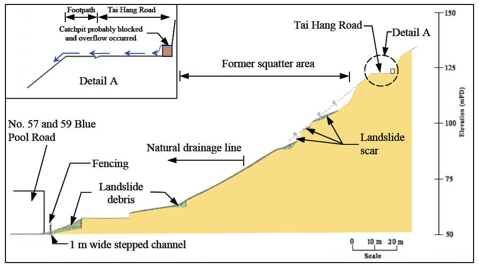
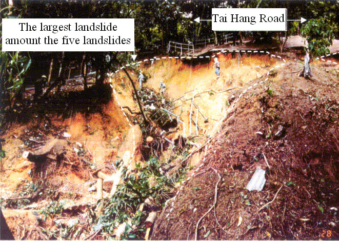
The 24 August 2000 Landslides below Tai Hang Road, Happy Valley
Basic Data
Material:
Fill/Decomposed Granite
Feature Affected:
Disturbed terrain and hillside below Tai Hang Road
Volume:
360 m3 (Total)
Report Reference:
GEO Report No. 131
Description
A cluster of five landslides occurred on a disturbed hillside (with volume ranging from 10 m3 to 250 m3, part of which was formerly a squatter area, below Tai Hang Road. The landslide debris entered a natural drainage line. The outwash material of the landslide reached the car parking areas underneath a row of residential blocks on Blue Pool Road below the hillside. No casualties were reported.
The probable causes of the landslides were a combination of direct infiltration of rainwater and overflow of surface water from the road leading to significant water ingress into the ground below Tai Hang Road. Possible blockage of the catchpit which collects surface runoff from the hillside above Tai Hang Road leading to overflow was likely to be a key contributory factor to the landslides. The section of Tai Hang Road above the landslides was fairly flat and susceptible to flooding. The pedestrian footpath was not raised above the level of the adjacent carriageway and the absence of an upstand along the outer edge of the footpath meant that there was no effective barrier to the uncontrolled flow of surface runoff onto the disturbed hillside below Tai Hang Road.
CCTV survey revealed a 0.3 m x 0.4 m cavity immediately below the cross-road culvert at the connection with the subject catchpit. This could have provided another source of water ingress into the disturbed hillside below Tai Hang Road although the contribution from this source was unlikely to have been significant given the distance (about 15 m) of the defect from the landslide site.
Observations
The incident highlights the potential landslide hazard caused by the blockage of the road drainage system and the absence of a footpath upstand allowing an uncontrolled flow of surface runoff onto the hillside below.