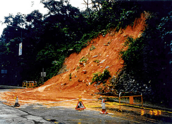
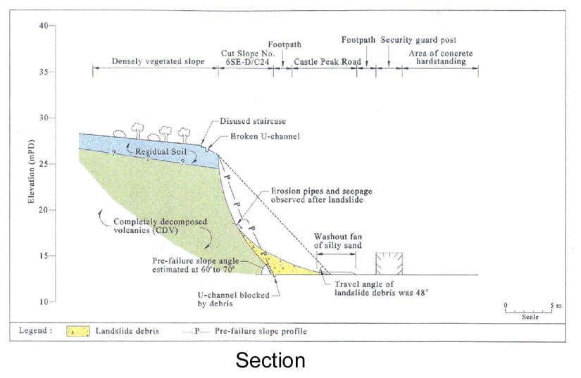
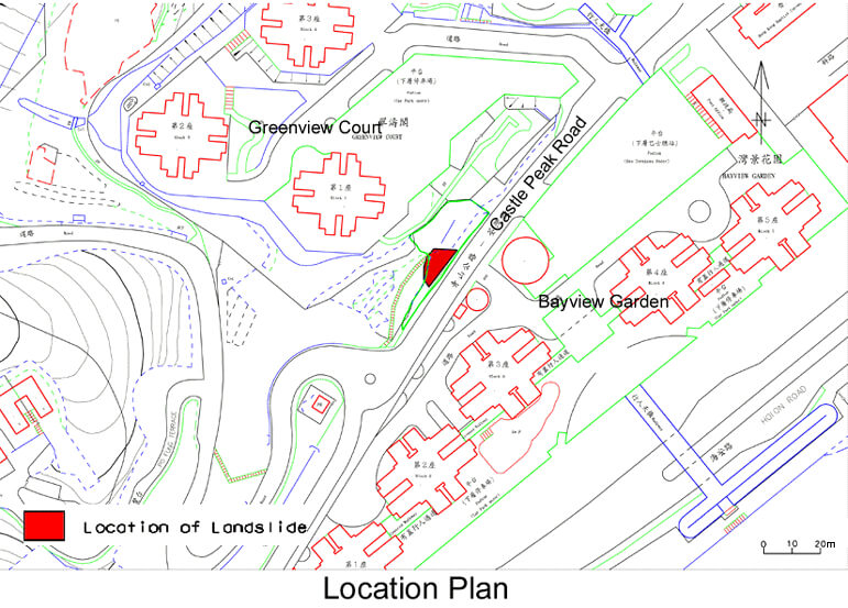
The 2 July 1997 Landslide Opposite Block 3 Bayview Gardens, Castle Peak Road, Tsuen Wan
Basic Data
Material:
Decomposed Volcanic Rocks
Feature Affected:
Cut Slope No. 6SE-D/C24
Volume:
70 m3
Report Reference:
Geo Report No.90
Description
The landslide occurred on a pre-1977, steep (60° to 70°), stone-faced cut slope, which had not been subjected to any detailed stability assessment or upgrading work at the failure location. An adjacent portion of the slope concerned was, however, upgraded previously by its private owner in 1982.
The landslide resulted in the blockage of the pavement and both lanes of Castle Peak Road.The landslide probably resulted from the development of elevated water pressures behind the slope surfacing due to infiltration of rain water through an unsealed ground surface at the slope crest. The rainfall preceding the failure (estimated maximum return period of about 6 years) was not particularly severe.
Deterioration of the stone facing, which was recorded in the Engineer Inspection carried out in 1995, may have been a contributory factor to the landslide.
Observations
The landslide highlights the possibility of progressive deterioration of slopes which could become liable to fail even given a rainstorm that is less severe than that experienced before when no failure occurred.
The slope as a whole had not been "signed-off" as being up to the required geotechnical standards. It is important to identify slopes with a 'partially-upgraded' status for consideration of the need for, and priority of, further attention.
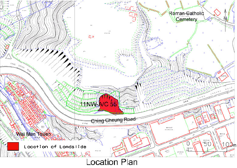
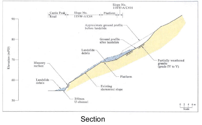
The 3 August 1997 Landslide at Ching Cheung Road
Basic Data
Material:
Decomposed Granite
Feature Affected:
Cut Slope No. 11NW-A/C55
Volume:
3,200 m3
Report Reference:
Geo Report No. 78
Description
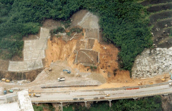
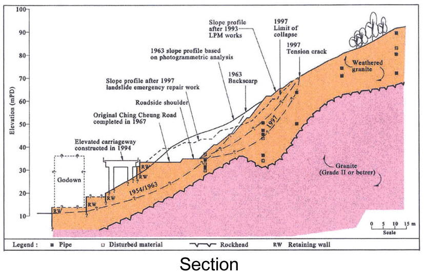
The failure resulted in the trapping of a motor car, the blockage of Ching Cheung Road and its closure for emergency stabilisation works. The failed slope was formed in the 1960's and has a long history of instability. In particular, past failure is evident at or near the location of the 1997 landslides on aerial photographs taken in 1945 and 1954. Ching Cheung Road, completed in 1967, crosses the site of past landslides.
A major landslide occurred on the subject slope in 1972, with a reported failure volume of 7,500 m3. Following the failure, raking drains up to 16 m long were installed in the lower two batters of the slope.
The cut slope was included in the 1988/89 LPM Programme and was upgraded by cutting back in the early 1990's. A minor failure occurred on the slope in 1993 within the failed area, after completion of the upgrading works.
In 1997, three major landslides took place at the slope on 7 July (500 m3), 17 July (700 m3) and 3 August (2,000 m3). Rainfall was heavy preceding and during the time of the first two landslides. The 7 July landslide was delayed with respect to heavy rainfall.
Infilled erosion pipes were identified in the soil mass. The history of landsliding is probably important in that the disturbance may have contributed to the development of the natural erosion pipe system, which is thought to influence the hydrogeology of the area.
Observations
This incident illustrates a number of important issues as follows:
All untested ground investigation cores/samples should be fully logged to examine for signs of past failures, pipes and other evidence of influence of subsurface water flow etc.
There was evidence of delayed groundwater response during the ground investigations carried out for the LPM works in 1989, but this was not explained in the geotechnical design report. Such findings should be fully considered in future slope assessments.
Designers should recognise the potential for high groundwater conditions and drainage concentration in slopes formed across natural drainage lines, particularly if the catchment is sizeable.
Due attention should be paid to the study of past failures at a site and factors identified must be fully considered in the design process.
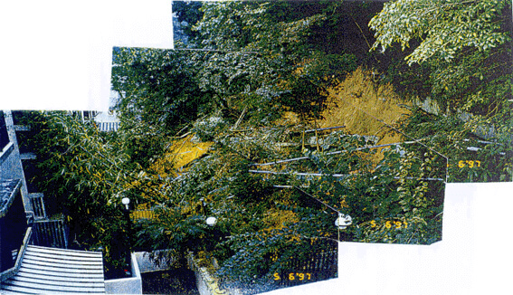
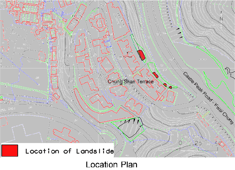
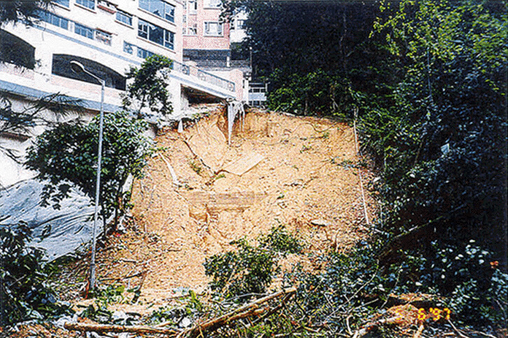
The 4 June 1997 Landslides at Nos. 1 to 5 Chung Shan Terrace, Lai Chi Kok
Basic Data
Material:
Decomposed Granite
Feature Affected:
11NW-A/CR261 & adjoining unregistered cut slope
Volume:
Four landslides with volumes ranging from 4 m3 to 85 m3
Report Reference:
Geo Report No.91
Description
The incident comprised four landslides on two adjoining soil cut slopes behind Chung Shan Terrace. No fatalities or injuries resulted from the landslides. One of the landslides, with a failure volume of 85 m3, occurred on the slope behind Block Nos. 4 and 5, which was upgraded in the late 1980's during the private redevelopment of that part of Chung Shan Terrace.
The other landslides, with a total volume of 14 m3, affected the adjoining slope behind Block Nos. 1 to 3 Chung Shan Terrace. This slope was assessed as being up to the required geotechnical standards as part of the site formation design for the redevelopment of Block Nos. 1 to 3 in 1992.
The landslides were triggered by rainfall which was the most severe storm (estimated maximum return period of about 50 years) experienced by the landslide site since 1978.
The failures were attributed to the development of seepage flow and the development of seepage pressure in the near-surface material, following direct infiltration of surface water.
Observations
The groundwater regime was assumed to be well below the toe of the slopes in the previous stability assessments of both slopes. The landslides highlight the fact that direct surface infiltration through the vegetated surface is liable to result in seepage flow and the development of transient groundwater pressure within the near-surface soil mass.
For slopes with a low base groundwater table, the assumption of zero water pressure in stability assessments, particularly for vegetated slopes, may not necessarily be sufficiently conservative. The detection of such shallow transient water pressure is fraught with difficulties given current ground investigation practice.
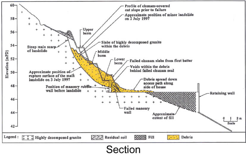
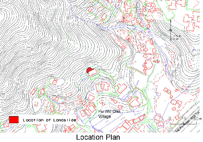
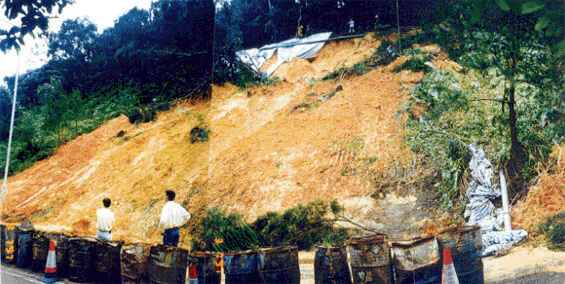
The 3 July 1997 Landslide at Nos. 142/143 Ha Wo Che, Shatin
Basic Data
Material:
Decomposed Granite
Feature Affected:
Cut Slope No. 7SE-A/CR375
Volume:
60 m3
Report Reference:
Geo Report No.92
Description
The incident affected a 9 m high, substandard soil cut slope that was formed in 1982/3 as part of site formation works for the construction of a New Territories Exempted House (NTEH). No detailed stability assessment was carried out and no geotechnical submission was made to the GEO for checking. No fatalities or injuries resulted from the landslide. However, occupants of the houses had to be temporarily evacuated as a result of the landslide.
Debris from the landslide piled up against house Nos. 142/143 Ha Wo Che and spread along the access at the rear of the house. Observations made by the occupants of the house suggest that the subject landslide were preceded by a small failure (5 m3) on the day before the major failure.
The landslide was triggered by rainfall which was the most severe storm (with an estimated maximum return period of about 120 years) experienced by the landslide site since 1980. Probable contributory factors to the failure include an adverse topographical setting that directed surface and subsurface water flow to the landslide site.
Observations
The incident highlights the potential hazard for failure of some post-1977 slopes (i.e. slopes formed after the establishment of the GEO) associated with New Territories Exempted Houses, which may not have been designed and checked to current safety standards under the slope safety system.
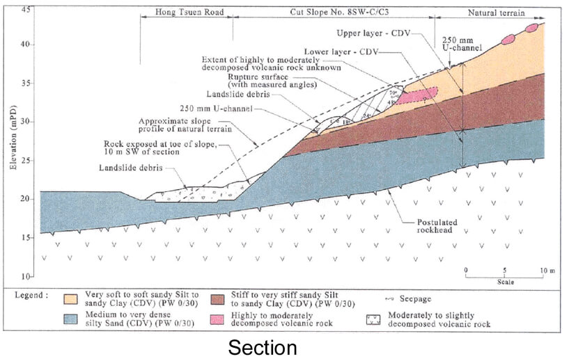
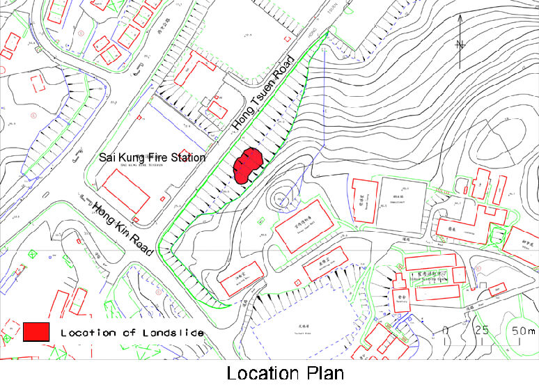
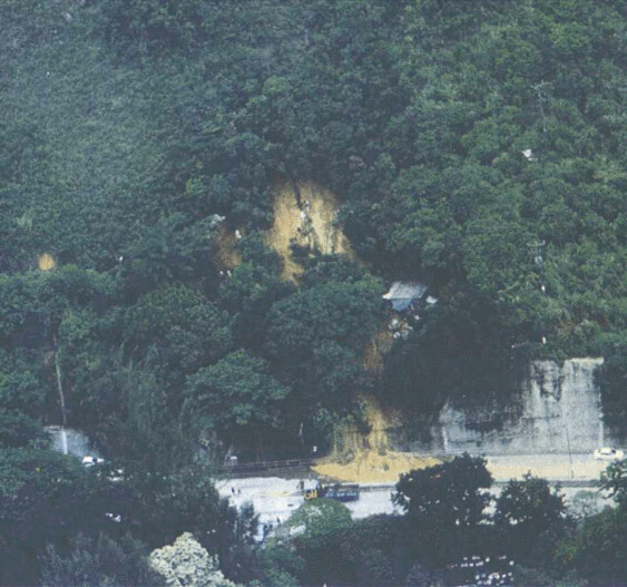
The 3 July 1997 Landslide at Hong Tsuen Road, Sai Kung
Basic Data
Material:
Decomposed Volcanic Rocks
Feature Affected:
Cut Slope No. 8SW-C/C3
Volume:
250 m3
Report Reference:
Geo Report No.91
Description
The landslide affected the central portion of a moderately inclined soil cut slope (30° to 35°) and its debris blocked both lanes of Hong Tsuen Road, which is at the toe of the slope. The slope was formed in the late 1970's as part of the Sai Kung Phase 3 Development and was designed and checked to the required geotechnical standards. No fatalities or injuries resulted from the landslide. The travel angle of the debris was 25o, which suggests that the failure was relatively mobile compared to other rain-induced landslides of similar volume in Hong Kong.
The landslide was probably triggered by severe rainfall which had an estimated maximum return period of about 40 years.
The failure involved decomposed volcanic tuff (CDT) with a high fines content. The low shear strength of this material and the development of high groundwater pressure within the upper clay-rich layer were significant contributory factors to the landslide.
Observations
The landslide highlights the potential danger of using generalised parameters without an adequate appreciation of the nature of the material involved.
The potential for low shear strengths and high groundwater at the site appears to have been under-estimated.
The 4 June 1997 Landslide at Hut No. 26 Kau Wa Keng Upper Village
Basic Data
Material:
Decomposed Granite
Feature Affected:
Cut Slope Nos. 11NW-A/C415 & 11NW-A/C416
Volume:
550 m3
Report Reference:
Geo Report No.76
Description
The landslide involved two cut slopes that were formed in the late 1950's, together with a portion of the natural terrain above. The landslide resulted in one fatality, the slight injury of five people and the blockage of two lanes of Castle Peak Road.
The upslope part of the slip surface of the landslide occurred mostly along a discontinuity, dipping adversely out of the slope at an angle of about 30°.
The landslide was probably caused by an increase in groundwater pressure following very heavy rainfall (the rainfall preceding the landslide was the most severe recorded by the nearest automatic raingauge for durations of less than 8 hours).
The hydrogeological setting of the landslide site (i.e. the presence of a surface layer of more permeable colluvium, the existence of partly coated adversely orientated discontinuities and the presence of a local shallow rockhead profile) was favourable to infiltration of rainwater and development of perched water pressure. The cut slope formed at the toe of the hillside would probably have contributed to causing the landslide involving the ground above the cut.
Observations
The incident illustrates the following important issues:
The site has a history of instability. The importance of taking full account of the geological and geomorphological setting, the history of site development and possible adverse effects from previous landslides in slope stability assessments is emphasised.
Unsupported cuttings on hillsides are likely to have a destabilising effect. The landslide consequence can be aggravated if a substantial portion of the failure involves part of the natural terrain, particularly where the terrain is of marginal stability.
Perching of groundwater within the weathering profile (PW 0/30) is possible (i.e. within relict discontinuities) and may need to be considered in slope studies as appropriate.
The 8 May 1997 and 4 June 1997 Landslides at Kwai Chung Road, Lai King
Basic Data
Material:
Decomposed Granite
Feature Affected:
11NW-A/C79
11NW-A/C78
Volume:
15 m3
23 m3
Report Reference:
Geo Report No.90
Description
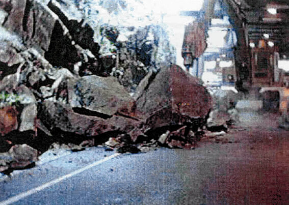
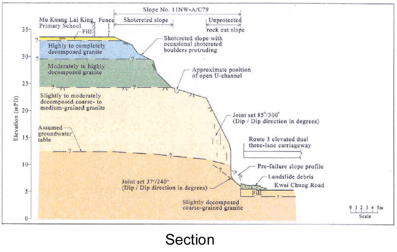
The landslide on 8 May 1997 affected the lower portion of rock slope No. 11NW-A/C79. The debris comprised several large angular blocks of rock and numerous smaller-sized rock fragments. The landslide resulted in the blockage of the inside lane of the Kowloon-bound of Kwai Chung Road and its closure until February 1998 to allow remedial works to be carried out. No fatalities or injuries resulted from the landslide.
The failed cut slope was upgraded under the LPM Programme in 1987. The upgrading works comprised scaling, application of slope protection, installation of rock bolts and dowel bars together with provision of drainage measures.
The landslide was probably caused by increase in water pressure at adversely-orientated discontinuities following direct infiltration of rainfall. Some of the discontinuities were infilled with 50 mm thick (maximum) of soft clay. The rainfall preceding the failure was relatively severe with an estimated maximum return period of about 40 years.
The landslide on 4 June 1997 occurred on the southern part of rock slope No. 11NW-A/C78. Its debris, which comprised rock fragments typically less than 1 m3 in size, accumulated on open space at the toe of the slope. No fatalities or injuries resulted from the landslide.
Slope No. 11NW-A/C78 was upgraded under the LPM Programme in 1987. The LPM works included installation of rock bolts and dowels, localised re-surfacing and sealing of vertical joints with mortar. However, the effect of groundwater appears not to have been adequately considered in the design of the upgrading works.
The landslide involved sliding of detached rock blocks on a basal discontinuity inclined at about 25o dipping out of the slope. The surface of the discontinuity was infilled with 20 mm thick (maximum) clay-rich material.
The landslide was probably caused by local development of transient water pressure on the clay-infilled basal discontinuity in response to infiltration of rainfall into the unprotected area upslope of the landslide site.
The rainstorms that triggered the landslides were the most severe (with an estimated maximum return period of about 40 years) experienced by the landslide site since the completion of the LPM works in the late 1980's.
Observations
The landslides illustrate some important issues, as follows :
The practice of relying on conventional stereographic projections and generalised assumptions about joint strength parameters, groundwater, block size, etc. may not be adequate in catering for local defects in a rock mass.
There is merit in reviewing the stability of engineered slopes (i.e. with geotechnical engineering input in the past) as part of the integrated slope assessment during re-development projects.
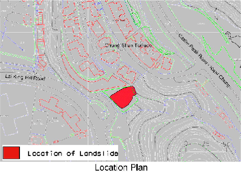
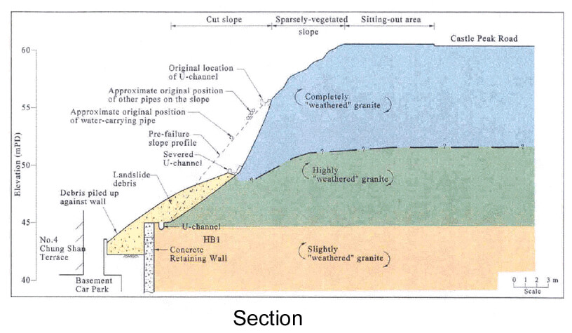
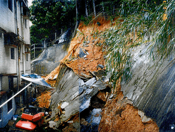
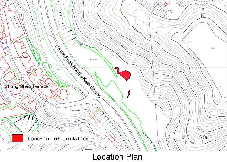
The 4 June 1997 Landslide at Chung Shan Terrace, Lai King Hill Road
Basic Data
Material:
Fill
Feature Affected:
Unregistered Fill Slope
Volume:
450 m3
Report Reference:
Geo Report No.89
Description
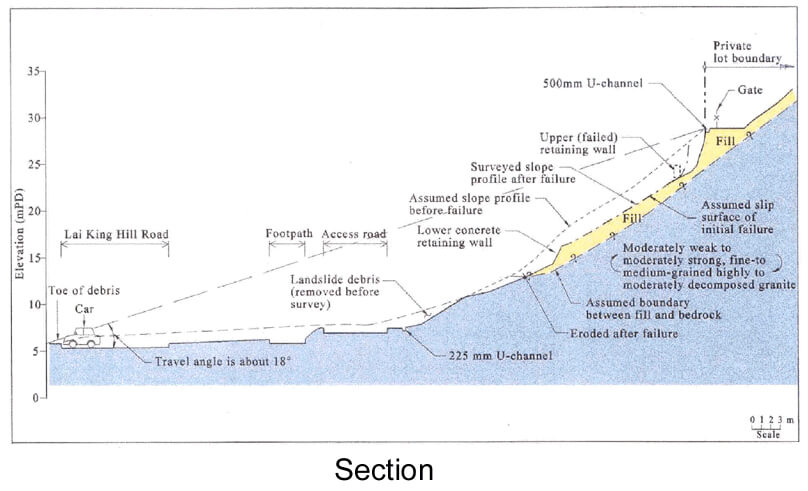
The landslide involved liquefaction of an unregistered loose fill slope formed in the 1960's during construction of residential buildings on the platform near the crest of the failed slope. The landslide resulted in complete blockage of Lai King Hill Road and an access road to Chung Shan Terrace.
The landslide debris was mobile with a travel angle of about 18o. Debris from the landslide crossed the access road at the slope toe and it struck a passing vehicle, pushing it some 30 m over gently-sloping ground. The passengers in the car were not injured.
The landslide was triggered by a rainfall event that was the most severe storm (for rainfall durations less than 12 hours) recorded by the nearest automatic raingauge since its installation in 1978.
Probable contributory factors to the landslide include the loose nature of the fill, leakage of a combined stormwater and foulwater drainage system above the failed slope, infiltration into the unprotected fill surface and the existence of buried, old retaining walls which dammed groundwater flow.
Observations
The incident was a 'near-miss' case as passengers in the car struck by the debris only narrowly avoided injury. It highlights the hazard posed by sudden liquefaction failure of old loose fill slopes resulting in mobile debris.
The 2 July 1997 Landslide at Li Po Chun United World College, Wu Kai Sha
Basic Data
Material:
Fill
Feature Affected:
Fill Slope No. 7NE-D/F99
Volume:
25 m3
Report Reference:
Geo Report No.91
Description
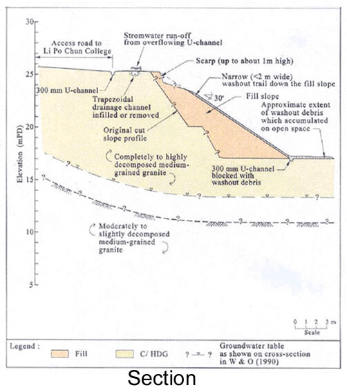
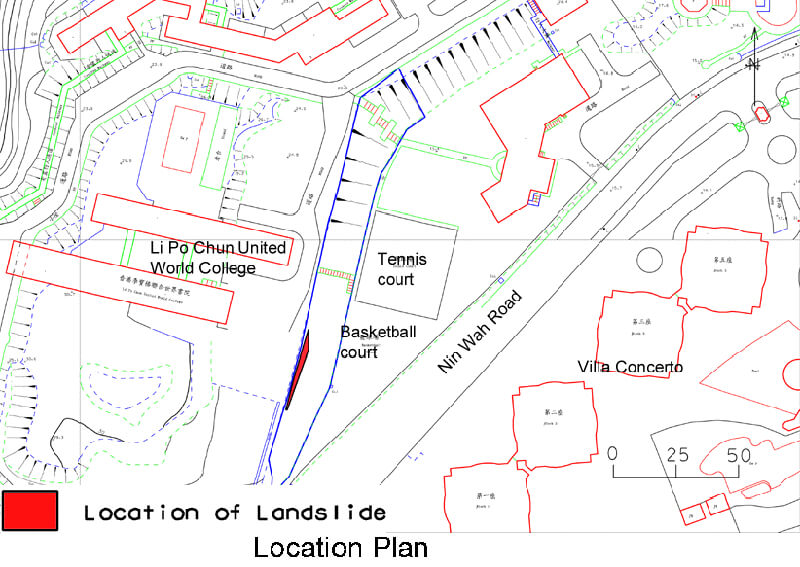
The incident affected a newly-formed fill slope which had been designed and checked to the required geotechnical standards. The fill slope has been constructed over an old, steep cut slope (No. 7NE-D/C44) during site formation works for the development of Li Po Chun United World College at Wu Kai Sha. Debris from the landslide was deposited on an open space. No fatalities or injuries resulted from the landslide.
The presence of poorly compacted fill and blockage of a U-channel at the crest of the fill slope, which might have diverted surface water onto the slope, were probably significant contributory factors to the failure.
The crest U-channel had not been connected to a nearby trapezoidal drainage channel as specified on the approved design drawings. This might have promoted blockage and ponding of the crest U-channel.
The rainfall that triggered the landslide was the most severe experienced by the site since the formation of the new fill slope, with an estimated maximum return period of about 30 years.
Observations
The incident emphasizes the importance of proper workmanship, supervision and compliance testing to ensure the proper construction of compacted fill slopes.
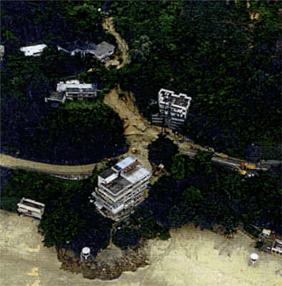
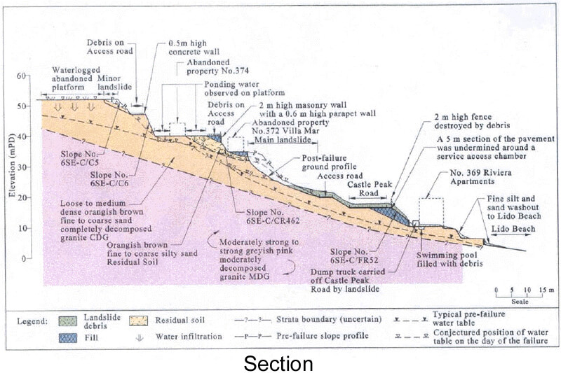
The 2 July 1997 Landslide at Lido Beach, Castle Peak Road
Basic Data
Material:
Decomposed Granite & Fill
Feature Affected:
Partly Modified Natural Terrain & Fill Slope No. 6SE-C/F3
Volume:
750 m3
Report Reference:
Geo Report No.89
Description
The landslide occurred on a 15 m high, partly modified natural terrain and affected an adjacent fill slope that was formed in the 1950's upslope of Castle Peak Road. Eight people were injured as a result of the landslide.
Debris from the landslide travelled some 70 m, completely blocking Castle Peak Road. The travel angle of the debris was about 20° which reflects that the failure was mobile when compared to other rain-induced landslides of similar volume in Hong Kong.
The landslide involved two phases of detachment. Eight people were trapped and injured by the debris associated with the second phase of failure.
The landslide was probably triggered by an increase in groundwater pressure in the slope caused by the effects of direct infiltration of rainwater and ponding within the uncovered area of an abandoned property directly upslope of the landslide.
Observations
The incident highlights the need to properly address abandoned properties close to slope crests with regard to the potential for water ponding in unpaved platforms and effects on water pathways.
The incident also emphasizes the potential hazard involved in secondary failures and the need to take the necessary safety precautions when attending to landslide sites.

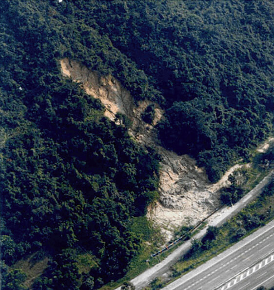
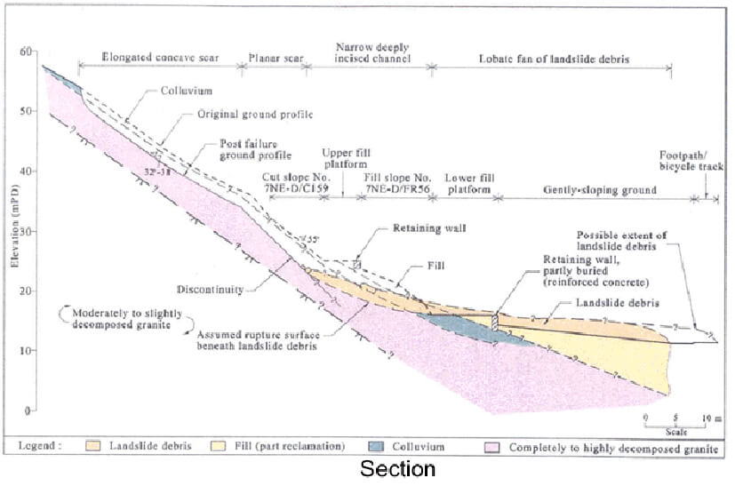
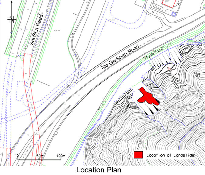
The 2 or 3 July 1997 Landslide Opposite Shing On Temporary Housing Area, Ma On Shan Road
Basic Data
Material:
Decomposed Granite
Feature Affected:
Predominantly Natural Terrain + Features Nos. 7NE-D/C159 & 7NE-D/FR56
Volume:
3,000 m3
Report Reference:
Geo Report No.90
Description
The landslide occurred mostly in natural terrain but also involved a cut slope and two fill platforms located on the lower part of the hillside. No fatalities or injuries resulted from the landslide.
The landslide involved retrogressive failure, initiated at the substandard man-made features. An adversely orientated, persistent and planar discontinuity at shallow depth, with weak infill, provided an intrinsic plane of weakness that controlled a large part of the failure.
The landslide probably occurred during exceptionally heavy rainfall, for which the estimated maximum return period was about 1,000 years.
The old substandard man-made slopes were constructed across a gully which has a history of instability. It is probable that the failure was initiated at the man-made slopes, because of surface water concentration in the gully and subsurface water flow, which in turn triggered further failures of the ground above.
Observations
The landslide highlights the potential hazard posed by failure of natural terrain triggered by collapse of sub-standard man-made features. The road could have been affected if the buffer zone provided by the footpath/bicycle path had not been present.
The failure also points to the potential for escalation of the consequence of relatively small failures on substandard man-made slopes below marginally stable natural terrain in an adverse geological/hydrogeological setting.
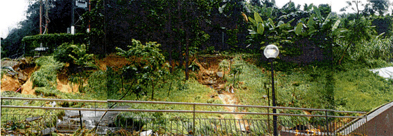
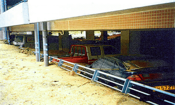
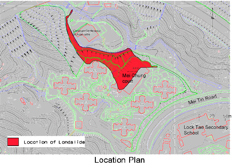
The 2 July 1997 Flooding Incident at Mei Chung Court, Shatin
Basic Data
Material:
Flood Debris
Feature Affected:
Cut Slopes Nos. 7SW-D/C790, 7SW-D/C791 & 7SW-D/CR801
Volume:
About 100 m3
Report Reference:
Geo Report No.79
Description
The flooding incident occurred during heavy rain, because of blockage of a nearby natural stream course that caused stream flow to overspill into Mei Chung Court Estate. This resulted in severe erosion of engineered man-made slopes at the perimeter of the estate and the inundation of the lower level of a multi-storey car park with floodwater and debris. No fatalities or injuries resulted from this incident.
The rainfall preceding the incident was not severe with an estimated maximum return period of about one year.
The man-made slopes were previously designed and checked to the required geotechnical standards. The surface drainage and slope protection measures were not designed to take account of the possibility of overspill from the natural stream course.
Observations
This incident highlights the problem of overflow from natural stream courses affecting downslope developments and the need to continue to pay due attention to this aspect in the preparation and review of planning documents.
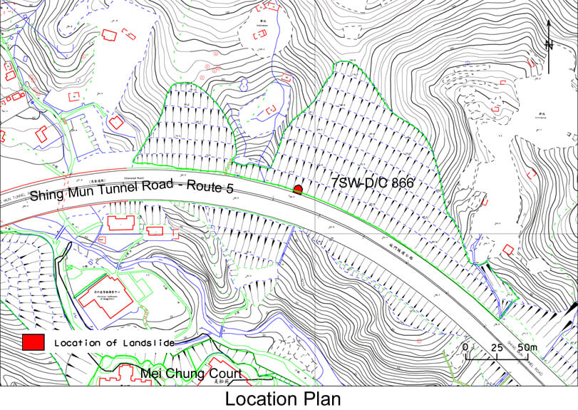
The 2 July 1997 Landslide at Shing Mun Tunnel Road, Route 5, Tai Wai
Basic Data
Material:
Decomposed Granite
Feature Affected:
Cut Slope No. 7SW-D/C866
Volume:
10 m3 plus > 50 m3 of Distressed Ground
Report Reference:
Geo Report No.92
Description
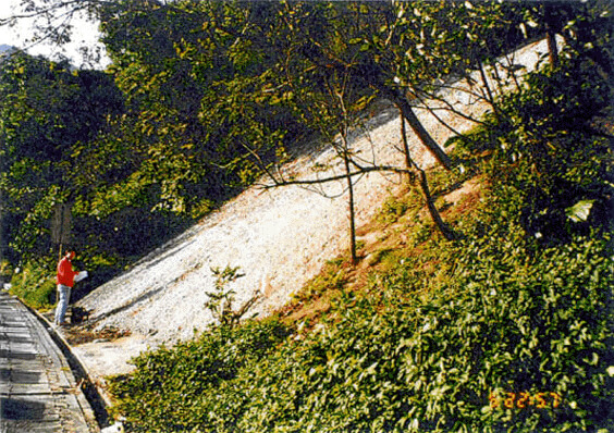
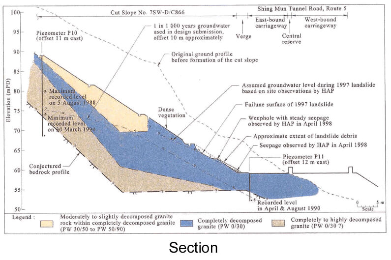
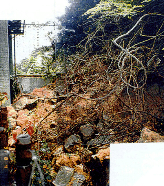
The incident affected a 70 m high soil cut slope that was formed in the 1980's as part of the Route 5 Shatin Connection project. The slope was designed by a geotechnical consultant and the design was submitted to the GEO for checking. However, outstanding queries about the design groundwater assumptions were not resolved. The slope cannot, therefore, be taken as having complied with current geotechnical standards. No fatalities or injuries resulted from the landslide.
The incident involved a small failure on the lowest batter of the slope. The investigation subsequently identified an open sub-vertical tension crack, which was 40 m long, with an aperture of 0.4 m and open to a depth of at least 1.5 m, on the next batter upslope of the small failure. The weathered appearance of the tension crack, as well as the presence of vegetation in the crack, indicated that the feature had been present for some time. The tension crack was not identified during inspection of the small failure or in previous maintenance inspections of the slope.
The primary cause of the small failure was probably related to elevated groundwater pressure in response to the severe rainfall (with an estimated maximum return period of about 38 years) preceding the failure.
Large-scale relict landslides on the concerned terrain were identified from aerial photographs dated before the site formation works. It is possible that the small failure, together with the persistent tension crack and signs of distress on the slope, could be surface expressions of the development of a deeper-seated instability.
Observations
The incident highlights the importance of inspecting areas surrounding landslide incidents and looking for signs of distress and evidence of instability during slope maintenance inspections.
The incident also emphasizes the need to take account of past slope performance, in particular the occurrence of relict large-scale instabilities, in slope assessments.
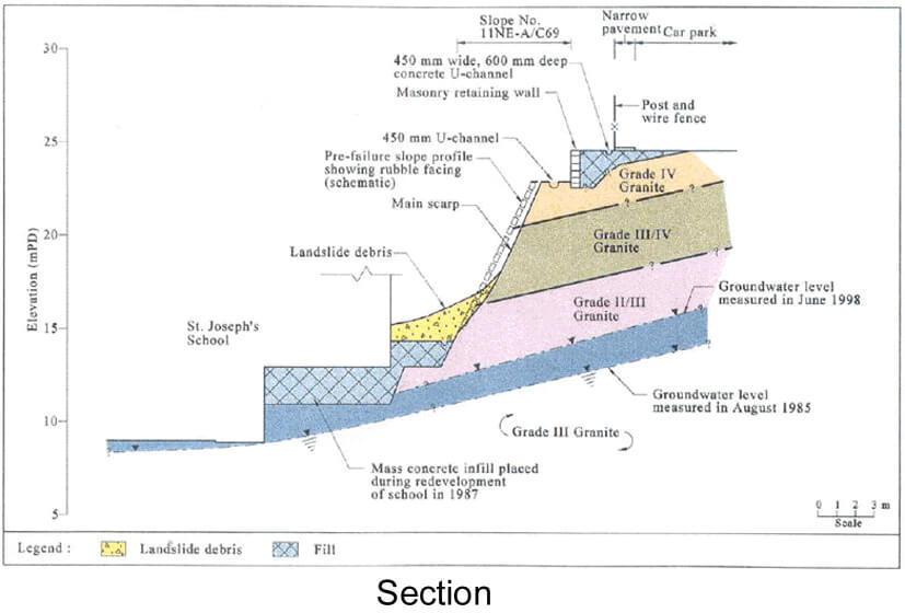
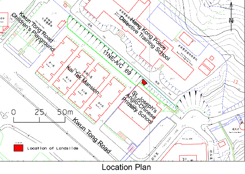
The 3 August 1997 Landslide at St. Joseph's Anglo Chinese School, Ngau Tau Kok
Basic Data
Material:
Decomposed Granite
Feature Affected:
Cut Slope No. 11NE-A/C69
Volume:
25 m3
Report Reference:
Geo Report No.90
Description
The landslide affected a rubble-faced portion of a steep (65° to 70°) soil/rock cut slope formed before 1949, that had previously been subjected to a detailed stability assessment in the mid-1980's and checked by the GEO. The landslide resulted in the blockage of a narrow walkway between the slope and the back of a school located at the slope toe.
Overflow from a surface drainage channel at the crest of the slope that had become blocked (partly because of the presence of a piezometer chamber in the channel) and the presence of open joints in the rubble facing, which allowed infiltration into the slope, were important factors in the failure.
The slope has a history of past failures and the subject landslide was a local failure. This part of the slope was possibly the location of a past instability.
The landslide occurred during moderate rainfall with an estimated maximum return period of about 3 years. This suggests that lack of maintenance and deterioration of the rubble facing may have been contributory factors to the failure.
Observations
The landslide highlights the possibility of progressive slope deterioration, the importance of slope maintenance and the need for attention to good slope detailing.
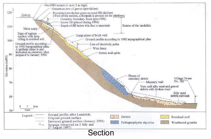
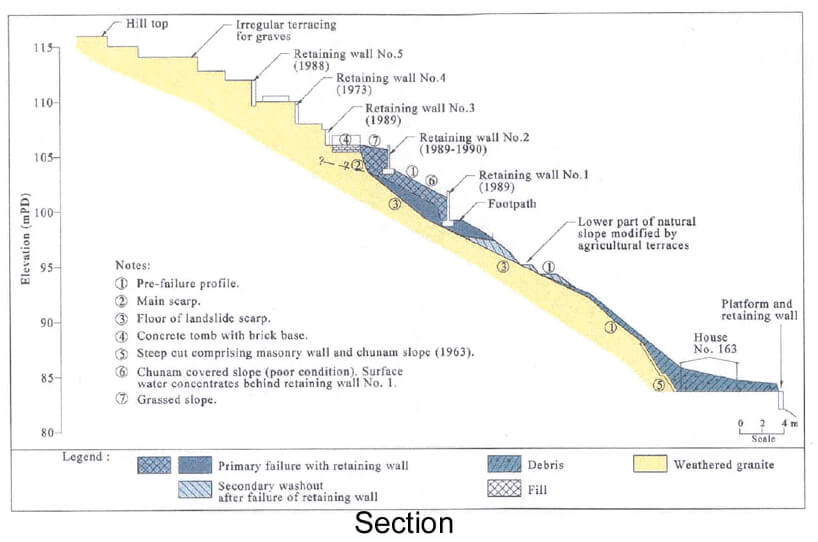
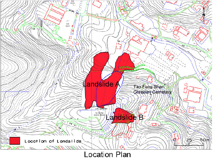
The 2 July 1997 Landslides at Tao Fung Shan Christian Cemetery, Shatin
Basic Data
Landslide A
Material:
Fill
Feature Affected:
Unregistered Fill Slope
Volume:
900 m3
Report Reference:
Geo Report No.89
Landslide B
Material:
Fill
Feature Affected:
Fill Slopes No. 7SW-B/R51 & 7SW-B/R50
Volume:
400 m3
Report Reference:
Geo Report No.89
Description
Two landslides occurred on separate slopes along the northern (Landslide A) and the eastern (Landslide B) slope boundaries of Tao Fung Shan Christian Cemetery.
Landslide A
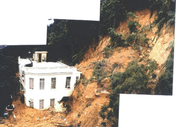
Landslide A involved an unregistered fill slope which was tipped in an uncontrolled manner on the upper parts of the hillside during 1996. The landslide caused damage to several abandoned and derelict buildings at the slope toe but no injuries or casualties were reported.
An estimated volume of about 300 m3 of soil and debris was entrained as the landslide travelled down the natural hillside. The overall travel angle of the landslide was about 30°
Inadequate surface protection of the fill slope, together with the presence of soil erosion pipes, would have contributed to the rapid saturation of the fill, which in turn reduced the stability of the slope.
Increased surface runoff and concentrated flows resulted from the replacement of natural terrain by paved areas of the cemetery above the fill. These, together with inadequate surface drainage provisions at the crest of the hillside, were significant factors in causing the failure.
Landslide B
Landslide B involved the failure of two registered concrete retaining walls, which were constructed in the late 1980's. Construction of these retaining walls was unauthorised and no design was submitted to the GEO for approval. The landslide resulted in the partial destruction of a squatter dwelling but no injuries or casualties were reported.
Debris from the landslide travelled some 25 m downslope and the total volume of the failure included some 150 m3 of material entrained from the natural terrain during debris runout.
Ingress of surface water into the fill behind the failed retaining walls due to lack of maintenance of chunam cover, together with the surcharge loading due to the walls and the saturated fill behind them, were probably contributory causes of the failure.
Observations
The fill slope involved in Landslide A was not registered at the time of failure. The landslide was a 'near-miss' incident in that the debris stopped just short of the dwellings below. This highlights the potential impact of failure of relatively small man-made slope features located on steep hillsides.
The replacement of natural terrain with paved areas will alter surface water drainage paths, increasing runoff and concentrating water flows. Attention to proper surface water drainage provisions is critical to avoid ponding and uncontrolled water discharge, particularly for hilltop developments overlooking facilities located lower down the hillside.
Landslide B highlights the potential hazard posed by unauthorised site formation works.
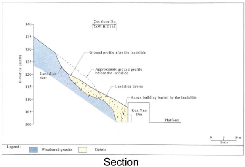
The 2 July 1997 Landslide at Ten Thousand Buddhas' Monastery
Basic Data
Material:
Decomposed Granite
Feature Affected:
Cut Slope No. 7SW-B/C116
Volume:
1,500 m3
Report Reference:
Geo Report No.77
Description
The landslide occurred predominantly in a 15 m high soil cut slope formed before 1945, but included a significant portion of the natural hillside above. The landslide resulted in one fatality and the slight injury of one person. A building (Kun Yam Din) was damaged and its annex building was buried by the debris.
The landslide was controlled by the presence of adversely orientated relict discontinuities. The rupture surface developed partly along persistent sheeting joints, with silt infill in places, dipping out of the slope but without daylighting. Sub-vertical discontinuities provided release surfaces as well as allowing surface water to penetrate into the soil mass.
There is evidence of past slope movement in the form of infilled tension cracks and open sub-vertical joints. The presence of soil erosion pipes, partly open vertical cracks, relict joints and veins were significant in the build-up of groundwater pressures through rapid infiltration.
There is evidence of past instability of the area based on aerial photographs. Lack of maintenance of the old soil cut slope was probably a contributory factor to the failure.
The rainfall event that triggered the landslide was the most severe, for durations of between 20 minutes and 3 hours, with an estimated maximum return period of about 25 years.
Observations
The incident illustrates a number of important issues, including the following:
Evidence of past slope movement (i.e. minor failures identified on aerial photographs and open partly-infilled sub-vertical cracks) as revealed during the landslide investigation suggests the possibility of progressive slope deterioration leading to enhanced infiltration. It also highlights the importance of slope investigations and maintenance inspections to look for such tell-tale signs of potential slope instability.
The sheeting joints that largely controlled the failure did not daylight in the cut slope. The need to consider such factors in the investigation and design of cut slopes should be noted.
The case highlights the need for preventive maintenance measures to improve surface protection and drainage, and the importance of regular maintenance inspections and follow-up works.
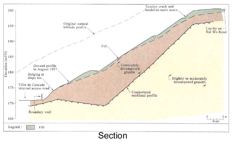
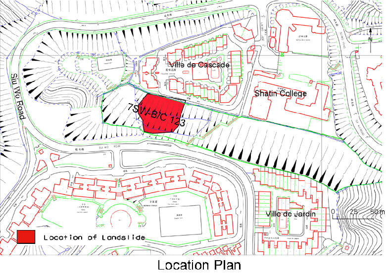
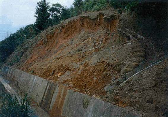
The 3 July 1997 Landslide at Ville de Cascade, Fo Tan, Shatin
Basic Data
Material:
Fill & Decomposed Granite
Feature Affected:
Cut Slope No. 7SW-B/C123
Volume:
15 m3 Detached Plus 2,500 m2 of Distressed Ground
Report Reference:
Geo Report No.92
Description
The landslide occurred on a 27 m high cut slope that was designed and checked to the required geotechnical standards in the early 1980's. No fatalities or injuries resulted from the landslide.
The 1997 incident involved a minor failure near the crest of the slope and an extensive area of distress that exhibited major tension cracking and displacement of surface channels at the toe of the slope. Bulging of the slope toe over an area of about 30 m in length was also observed.
A number of failures have occurred on the slope since its formation. There is evidence of high groundwater conditions having occurred at the site in the past. Large-scale relict landslides, which pre-date formation of the cut slope and partially coincide with the location of the 1997 incident, have also been identified from aerial photographs.
The rainfall that triggered the landslide was the most severe experienced by the site, with an estimated maximum return period of about 150 years.
It is possible that the failure and signs of distress are surface expressions of the development of deeper-seated instability. The cause of failure was probably related to elevated groundwater pressure in a deep weathering profile in response to heavy rainfall.
Observations
The incident occurred on a slope with a history of instability and evidence of complex hydrogeological and geological conditions. It highlights the importance of adequate engineering-geological input to recognise or look for such conditions and ensure more detailed investigation and robust design solutions. The importance of inspecting areas adjacent to failures to identify the potential for larger-scale landsliding is also emphasized.
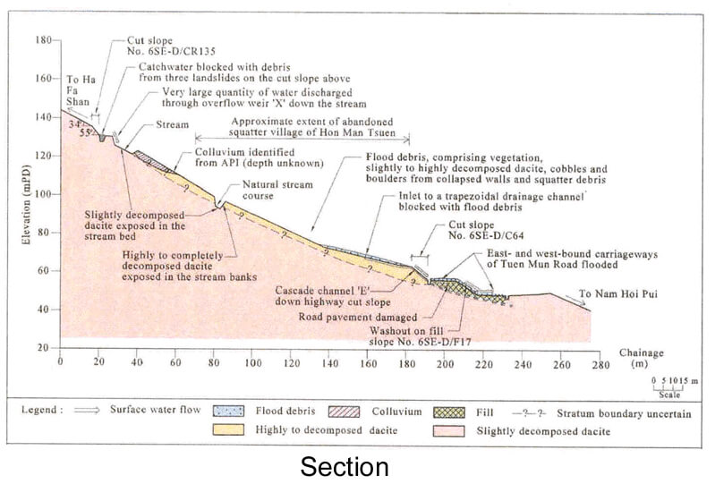
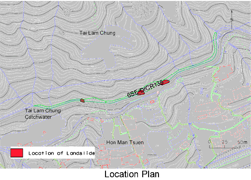
The 2 and 3 July 1997 Flooding Incident at Tuen Mun Road, Yau Kom Tau
Basic Data
Material:
Completely Decomposed Dacite
Feature Affected:
Cut Slope No. 6SE-D/CR135
Volume:
35 m3 - 280 m3
Report Reference:
Geo Report No.79
Description
Three failures of between 35 m3 and 280 m3 occurred at slope No. 6SE-D/CR135, which is located above Tai Lam Chung catchwater, some 80 m upslope from Tuen Mun Road. The failures resulted in the flooding of the east- and west-bound carriageways of Tuen Mun Road which were closed for 15 1/2 hours and 5 1/2 hours respectively. No fatalities or injuries were reported.
The failed cut slope was formed before 1978 and was not designed to the required geotechnical standards. The cut slope and the natural terrain above has a history of instability.
Debris from the landslides blocked the catchwater causing surface water to discharge through an overflow weir into a drainage channel on the slope between the catchwater and Tuen Mun Road. The sediment load of the stream flow, which included a proportion of material eroded from the stream bed of the drainage channel, choked the surface drainage system at the crest of a cut slope adjacent to Tuen Mun Road, causing uncontrolled discharge onto the roadway.
Observations
The incident illustrates the importance of designing drainage lines downstream of catchwater overflows to accommodate extreme flows and prevent erosion, taking due account of the possibility of blockage of the catchwater by landslide debris.
Precautionary measures (e.g. decking of catchwaters) could be implemented to mitigate the effect of uphill slope failures in causing overflow from catchwaters onto the downhill developments.