The natural landscapes of Hong Kong, displayed in many of the Country Parks, are determined by the underlying geology and geomorphological processes. Human activities, such as reclamation and the construction of reservoirs, have considerable modified the original landscapes.
Geology and Geomorphology of Hong Kong
The two major rock types in Hong Kong, volcanic and granitic rocks, exhibit markedly different responses to the subtropical weathering processes that operate in this region today. These differences can be identified in the landscape.
The sedimentary rocks, which are largely restricted to the northeastern part of Hong Kong, form their own distinctive, low-lying and colourful scenery.
Volcanic Rocks
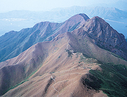
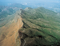
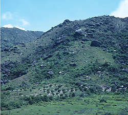
The volcanic rocks in Hong Kong have been relatively more resistant to sub-tropical weathering processes, so they produce the highest summits (e.g. Tai Mo Shan, Lantau Peak, Sharp Peak, etc.). Volcanic rocks give rise to a rugged, angular topography, generally with thin, silty, clayey weathered profiles (Figure 1).
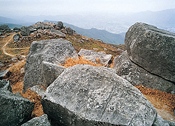
With the exception of coarse ash crystal tuffs (such as underlie Tai Mo Shan) (Figure 2), volcanic rocks do not produce corestones, so volcanic landscapes generally tend to be devoid of surface boulders.
Surface outcrops in the volcanic rocks occur largely as cliff faces on the steep hillsides, such as are seen on Lantau Peak and Ma On Shan.
Granitic Rocks
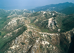
The granitic rocks in Hong Kong have been relatively more susceptible to sub-tropical weathering processes, so (with the exception of Lion Rock) tend to produce lower hills (e.g. Kowloon and the Tai Lam Country Park) (Figure 3). Thus, they give rise to a lower, more rounded topography with thick, silty, sandy weathered profiles, and numerous boulders over the surface.
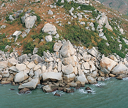
Weathering of the granitic rocks produces distinctive, rounded (usually ellipsoidal) corestones. They protrude from some natural slopes, but are more commonly seen, following their exhumation (having been eroded out) from weathered profiles, littering the surface of granitic terrain (Figure 4).
These boulders may be scattered evenly, or randomly, across the landscape, but are more commonly concentrated as dense accumulations over upland surfaces (boulder fields) and on slopes (boulder sheets), or they may be concentrated in lines along topographic depressions such as shallow water courses (boulder streams).
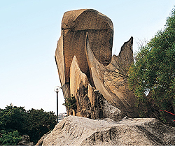
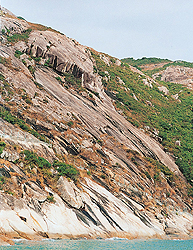
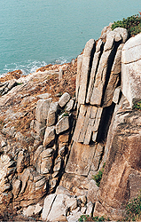
Surface outcrops of bedrock are common in the granitic rocks. They occur as tall, jointed rock outcrops (Figure 5) protruding from hill summits and ridge crests, and as curved rock slabs (stress relief joints) (Figure 6) and jointed rock buttresses on hillslopes and at the end of spurs (Figure 7).
Sedimentary Rocks
The sedimentary rocks, most of which are clearly bedded (layered), form distinctive and colourful landforms in the northeastern New Territories. They generally appear to be relatively resistant to weathering and develop only very thin weathered profiles.
Escarpments, at both small and large scales, occur when the beds are inclined so that they form a gently to moderately dipping slope (the dip slope) in one direction, with a very steep, near vertical slope (the scarp slope) in the other direction (e.g. the Pat Sin Leng escarpment) (Figure 8).
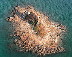
Other characteristic features developed within the sedimentary rocks include natural arches (e.g. Ap Chau), stumps (e.g. Kat O Hoi) (Figure 9), and wave-cut platforms (e.g. Ping Chau).
Geology of Hong Kong Country Parks
About 40% of the land area of Hong Kong is designated under the Country Parks Ordinance (Figure 10), which protects large areas of the natural landscape from the pressures of urbanisation, and preserves them for posterity. These areas encompass most of the wild upland regions, extensive sections of scenic coastline, and large segments of the outlying islands, making them ideal outdoor laboratories for geological and geomorphological studies.
Access to, and within, the Country Parks is unrestricted. However, it should be emphasised that the damaging of rock outcrops, for collecting rock samples or searching for fossils, is prohibited. Studies should be carried out purely by observation, description, measurement, sketching and photographing. In this way, irreplaceable geological features will be left intact and undamaged for future generations of students and visitors to observe.
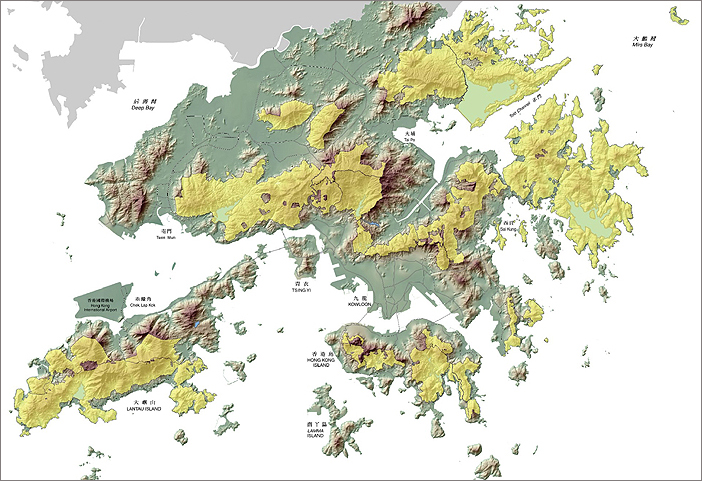
Figure 10: The Hong Kong Country Parks (shaded in yellow).
Tai Lam Country Park – Granitic Terrain, Weathering & Faults
The Tai Lam Country Park presents an excellent opportunity to examine a major fault-controlled valley, features of granite weathering including tors, boulders, resistant quartz veins, the effects of severe gully erosion, and erosion-control planting.
The Tai Lam Country Park is underlain by the Jurassic Tai Lam Granite, a medium- to fine-grained porphyritic granite, which has given rise to contrasting landscapes of rounded and eroded hills, and rocky tors with boulder fields.
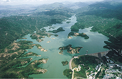
The Country Park is traversed by the northeast to southwest trending Tai Lam Fault. Deep weathering and preferential erosion along this extensive, linear fault trace has resulted in the straight master valley that today contains the Tai Lam Reservoir (Figure 11).
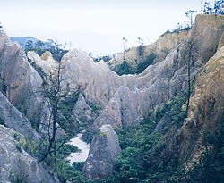
The granite in the central areas of the Country Park is deeply weathered and, following several periods of deforestation by successive waves of settlers, the area has been severely eroded to create a "badlands' landscape of deep erosion gullies and exposed sandy soils on the hill summits (Figure 12).
Prior to the implementation of erosion control measures in the 1980s, an intricate pattern of active erosion channels scarred the hills in this area. These comprised dendritic networks of small rills on the summit areas, which converge downslope to enter deep and narrow gullies. Headward erosion of the gullies has, in most cases, resulted in a very steep scarp at the head of the gullies. Tributary rills enter the gully at this point over what is, in effect, a waterfall.
Over recent years, trees have been planted over much of the area to control the damaging erosion, although the gullies are still preserved in the landscape.
Traverses of the hills will reveal a surface covered with a sandy, silty, slightly clayey soil. This material is the residue of granite weathering, comprising silt/clay derived from decomposition of the feldspars and sand derived directly from the quartz. The soil is crumbly and easily displaced, hence is very susceptible to erosion if not clothed with a protective cover of natural vegetation.
Traversing the summits and slopes, like low stone walls, are weathering- and erosion-resistant veins of white quartz. These veins have been exposed as the softer surrounding weathered granite was removed by erosion.
In other areas of the Country Park, granitic bedrock is exposed as blocky tors on hill summits, spur ends or valley sides, or as small cliffs on hillsides. Towards the southern margins, boulder fields mantle the summits and hillsides, and boulder streams choke the valleys (Figure 13).
Sai Kung Country Park – Volcanic Terrain and Coastal Processes
The southeastern part of the Sai Kung Country Park presents an excellent opportunity to examine fascinating columnar-jointed volcanic rocks that formed in an ancient volcanic depression.
The southeastern part of the Sai Kung Country Park is underlain by volcanic rocks of the Cretaceous High Island Formation.
The distinctive columnar jointed rocks of this Formation were formed in a large caldera, the Sai Kung Caldera, a large, low-rimmed volcanic depression that survived after the original volcanic centre had collapsed.
Evidence from the surviving fragments of the northwestern section of the caldera indicates that the Sai Kung Caldera was at least 20 kilometres in diameter. However, the locations of the former southern and eastern caldera rims lie somewhere out under the sea today.
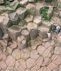
The columnar jointed rocks are tuffs, which originally accumulated as a very thick blanket of extremely hot volcanic ash on the floor of the caldera. The ash cooled slowly, gradually contracting and developing vertical joints that formed at right angles to the bounding surfaces.
From above, the cooling joints display a tightly interlocking hexagonal network (Figure 14). Hexagons are the most efficient geometrical "stacking' pattern.
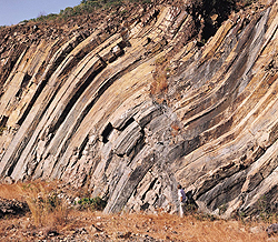
Most of the columns are vertical, or subvertical. However, close observation along the rock faces will reveal that, at certain locations, the columns are inclined or have a shallow S-curve (Figure 15). During the cooling process, the ash body would have passed through a plastic state. Continued volcanic activity in the region would have periodically produced earth tremors or local subsidence of the caldera floor, causing the ash layer to settle into the depression by a process of slow creep. The shape of the flexures generally indicates that creep was towards the southeast.
Looking out to sea, the columnar-jointed tuffs can be seen displayed along the offshore islands, where they form very distinctive vertical cliffs that rise abruptly out of the sea. The adjacent columns give the cliffs a striated appearance. The columns are also particularly well-developed on the Ninepin Group of islands to the south of the High Island area.
Erosion by the waves has resulted in the collapse of some columns, leaving vertical slots in the cliff faces. Where only the lower part of a column has collapsed, the slots are topped by overhangs. In other places, collapse of the upper sections of columns along inclined fractures has produced polygonal facets that slope towards the sea.
In some places, erosion along weaker, less erosion-resistant, zones has resulted in concentrated areas of column collapse, and the formation of sea caves.
More rarely, caves developing along weaker zones from opposite sides of a narrow promontory or headland have merged to create sea arches through the cliffs.
Pat Sin Leng Country Park – Sedimentary Rocks and Structures
The Pat Sin Leng Country Park presents an excellent opportunity to examine a large escarpment, the associated drainage patterns, a waterfall, and recent natural terrain landslides.
The Pat Sin Leng Country Park is predominantly underlain by Cretaceous rocks of the Pat Sin Leng Formation, which are in turn underlain by volcanic rocks of the Jurassic Tai Mo Shan Formation.
The Cretaceous rocks are reddish-brown, thickly bedded conglomerates, greyish red sandstones, and reddish purple siltstones that were originally laid down as beds in two main geological settings. Conglomerates and pebbly sandstones were deposited in river channels, and the overlying sheet-like sandstones were deposited by sheet floods in a semi-arid environment.
The rocks dip towards the north at about 20º to 25º to form the only large escarpment in Hong Kong (Figure 16). The crest of the escarpment forms a prominent ridge that extends from Wong Leng (639 metres high) in the west to Kwun Yam Tung (304 metres high) in the east.
Because of the asymmetrical shape of the escarpment, streams on the southern scarp slope have steep, linear, and very short courses, and only flow following rainfall. These are termed seasonal or ephemeral streams. In contrast, streams on the gentler northward sloping dip slope have longer courses, so they have developed a typical dendritic pattern, and flow almost all year. They are termed permanent or perennial streams. Consequently, villages on the southern side of the Pat Sin Leng escarpment receive very little water supply from the hills above them, whereas villages located on, or near the foot of, the dip slope tap into an almost permanent water supply.
Towards the centre of the escarpment, to the east of the summit of Shun Yeung Fun (588 metres high), the ridge is breached by a valley that is now occupied by the waters of the Plover Cove Reservoir. Near the head of the valley at Bride's Pool is a very scenic waterfall that plunges over a rock shelf composed of the Pat Sin Leng Formation.
This waterfall displays many classical features of waterfall development including a hard, resistant rock band, a well-defined knick point, undercutting at the base of the fall, an almost circular plunge pool, scouring of the rock that forms the bed of the stream, and deep potholes.
Several recent landslide scars can be seen on the steeper southern scarp slope, most of which are shallow, short runout features.
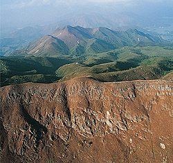
Figure 16:
The Pat Sin Leng escarpment.
The Urban Landscape
Natural processes have steadily eroded and shaped the land over thousands of years. More recently, human activities have changed the surface of the earth at rates far faster than those of natural processes. The original, pre-settlement, landscape of Hong Kong has been considerably modified by human activity, largely in order to supply additional building land, building materials, and reliable water supplies.
Hong Kong has limited flat land for building, and no lakes, large rivers, or major aquifers to provide drinking water. Consequently, flat land has been created by coastal reclamation (Figure 17) and site formation, quarrying has provided building materials and concrete aggregates, and water has been stored by building dams and impounding reservoirs. Together, these activities have had a profound effect on the onshore topography, the shape of the coastline, and the drainage pattern of Hong Kong, not only in the urban areas, but also in many of the New Territories villages.
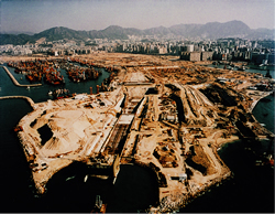
Figure 17:
West Kowloon Reclamination.
Coastal Reclamations
The first proposal for land reclamation in Hong Kong was made in 1855 for the Western Praya Scheme in the area of Kennedy Town. The scheme eventually began in 1868 and was completed in 1873, adding 50 acres (0.2 km2) to the waterfront.
A second reclamation scheme commenced in February 1890 and was completed in 1904, using about 3.5 million tonnes of material to create 65 acres (0.3 km2) of new land.
Over the succeeding years, the rate of reclamation increased almost exponentially. Between 1868 and 1967 a total of 10.0 km2 had been reclaimed, between 1967 and 1991 an additional 30.5 km2, and between 1991 and 1995 a further 19.0 km2 were reclaimed. In total, more than 60 km2 of land have been formed by reclamation (Figure 18).
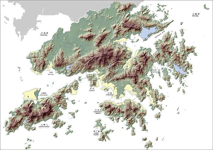
Figure 18: Reclamations in Hong Kong (shaded in yellow).
Most of the New Towns in Hong Kong, including Tin Shui Wai, Ma On Shan, Tseung Kwan O, Sha Tin, Tuen Mun, Tsuen Wan, and Tung Chung, comprise large areas of coastal reclamation.
Also, many of the notable developments in Hong Kong are located on reclaimed land, including the former Kai Tak Airport, the new Chek Lap Kok Airport (12.5 km2) (Figure 19), large areas of the Kowloon peninsula and Central District on Hong Kong Island, including the West Kowloon Reclamation (3.3 km2), as well as the Disneyland complex (2.0 km2).
Today, reclaimed land makes up about 6% of the onshore area of Hong Kong, development land that now supports housing for about 20% of the population.
The first reclamations were carried out using material provided by public dumping, including construction and household waste. Bunds were built, and city waste was deposited in the lagoons. This method was slow, taking many years to complete.
Several early reclamations were carried out using sand from offshore sources. These included the Kai Tak extensions (1929, 1931 and 1956-1959), the Causeway Bay Typhoon Shelter, Victoria Park, and Tuen Mun New Town.
Many large reclamations were carried out using weathered rock obtained by cutting back into hillsides. This method had the advantages of being faster than public dumping, and also created new land for housing developments in the "Borrow Areas".
However, there were several disadvantages to using weathered rock. The placed fill required a long period to settle because of the irregular particle sizes, which included large rock fragments, and the material drained slowly because of the clay content. Importantly, severe environmental disturbance was created in city areas during excavation and blasting, and by heavy vehicles transporting material to the coastline.
Offshore sand became the preferred fill option in the 1980s, pioneered by two important projects.
Container Terminal 6 was constructed between 1986 and 1989 using about 8.6M m3 of marine dredged sand, and the Tin Shui Wai New Town was constructed between 1986 and 1988 using about 24.0M m3 of sand. This method had the advantages of being rapid, creating minimal environmental disturbance onshore, and the placed fill drained and consolidated rapidly.
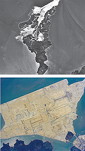
Figure 19:
Chek Lap Kok
before and after
the airport reclamation.
Major Site Formations
In addition to reclaiming land from the sea, development land is also created by levelling the tops of hills, by completely removing hills, and by cutting platforms back into steep hillsides.
There are many examples of this kind of site formation, at all scales from the erection of small village houses to the construction of vast housing complexes.
As urban development on the Kowloon peninsula gradually spread northwards, several large housing sites, such as Tsz Wan Shan and Chuk Yuen, were developed by cutting back into the Kowloon Foothills. Similarly, major projects such as the Kornhill development involved cutting into the hills on Hong Kong Island.
More recently, the Jordan Valley site formation included the removal of large quantities of rock (Figure 20).
Several projects, such as the the Tseung Kwan O New Town development, involved both major site formation and reclamation. Large-scale rock removal created housing platforms on the hillsides surrounding the bay, and much of the excavated rock was used as fill for extensive areas of coastal reclamation.
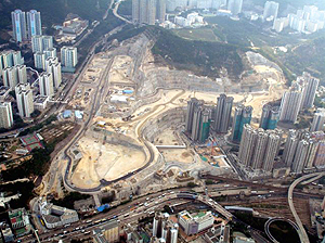
Figure 20: The Jordan Valley site formation.
Reservoirs and Catchwaters
About 33% of the 1,105 square kilometre area of Hong Kong has been developed as catchments to direct rainfall runoff from the hills into the fifteen "old' valley reservoirs in Hong Kong, and to the Plover Cove and High Island "marine' reservoirs (Figure 21).
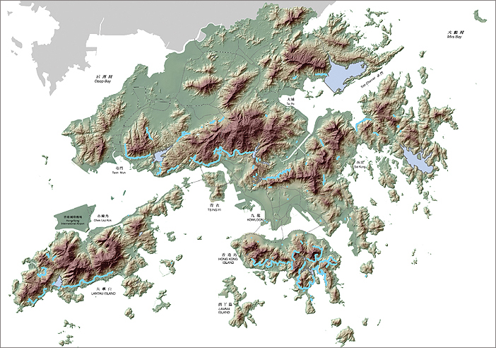
Figure 21: Reservoirs and catchwaters in Hong Kong (shaded in blue).
Pok Fu Lam was the first valley reservoir, completed in 1877. Fourteen other (surviving) valley reservoirs were built in the following 88 years, the last being the Lower Shing Mun Reservoir, which was completed in 1965. The total capacity of these fifteen reservoirs is 75 million cubic metres.
Several smaller reservoirs, including Jordan Valley and Wong Nei Chong, have been de-commissioned and either filled-in or removed.
The Plover Cove and High Island (Figure 22) reservoirs were both built by damming marine inlets. Plover Cove was initially completed in 1967, with a capacity of 170 million cubic metres, but the dam was later raised by 1973 to increase the storage capacity to 230 million cubic metres. The High Island Reservoir, completed in 1978, has a storage capacity of 281 million cubic metres.
The total storage capacity of Hong Kong's seventeen operational reservoirs is 586 million cubic metres, which is about 222 days supply for Hong Kong, or sufficient for 60% of the year.
A network of sub-contour channels (catchwaters) has been constructed around many of the hillsides of Hong Kong (Figure 21). They are designed to intercept the natural runoff from hillsides and upland streams, and to direct it into the reservoirs.
Catchwaters effectively behead the natural streams, and commonly transfer the runoff, via tunnels below the drainage divides, to adjacent watersheds. Thus, the natural drainage system in Hong Kong has been considerably modified, both in the urban areas where the former watercourses are culverted, and in many of the extra-urban areas where catchwaters redirect the runoff.
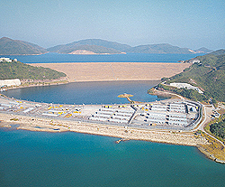
Figure 22: The High Island West Dam.