Folds and faults are geological structures that result from the response of rocks to tectonic stresses induced by plate movements. Structural geology is concerned with the description and analysis of structural features in rocks ranging from the microscopic to macroscopic scales. These studies enable the deformation history of a region to be deciphered. When combined with earthquake assessment and seismic monitoring, the deformation history can give an indication of the potential seismotectonic hazard in a region.
Faults in Hong Kong
Rocks at or near the Earth's surface are hard and generally behave in a brittle manner. When brittle rocks are subjected to tectonic forces, they may break along faults. This fracturing generates an earthquake. Plate boundaries are the most common site of earthquakes, because the rocks in these locations are subject to the greatest tectonic forces. Beyond plate boundaries, earthquakes are less common.
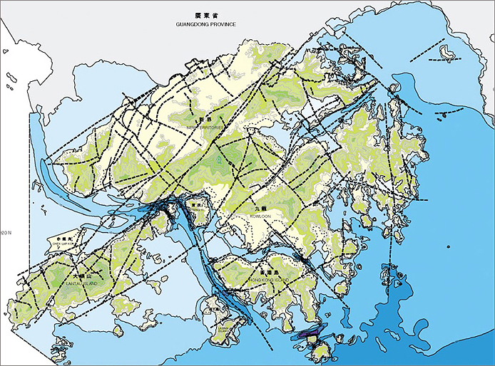
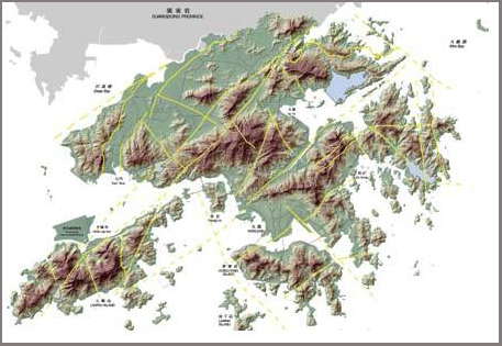
The main faults in Hong Kong (Figure 1) are oriented northeast-southwest, and northwest-southeast (Figure 2). They are generally of the same orientation as those in neighbouring Guangdong Province.
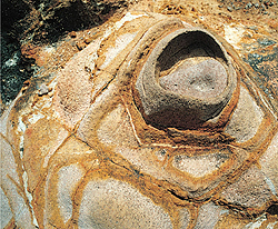
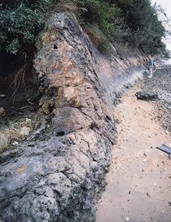
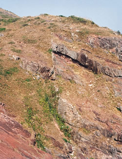
Individual faults in South China can be traced over distances of up to 60 km. Some faults are associated with fracture zones up to 1 km wide, although most faults appear to be only a few metres wide (Figure 3). Although faults are recorded throughout the known geological history of Hong Kong, they are considered to have been most active during the Jurassic to Cretaceous periods when strike-slip and thrust faulting was dominant. Many of these faults are thought to represent reactivation of older structures. Some faults represent structures that were active during the period of Late Jurassic to Early Cretaceous magmatic activity and facilitated the rise of magma to the surface. Regional gravity and magnetic data have been used to identify the locations and depths of these structures in the upper crust.
Faults - Brittle Deformation of Rocks
Three types of fault occur: normal (dip-slip) faults, reverse (dip-slip) faults, and strike-slip faults (Figure 4).
- Normal (dip-slip) faults occur when brittle rocks are stretched (i.e. the tectonic forces are tensional). Vertical movement occurs along the steeply inclined fault plane such that the hanging wall moves downwards relative to the footwall.
- Reverse (dip-slip) faults occur when brittle rocks are compressed (i.e. the tectonic forces are compressional). Vertical movement occurs along the steeply inclined fault plane such that the hanging wall moves upwards relative to the footwall.
- Strike-slip faults occur when brittle rocks are sheared (i.e. opposing tectonic forces are at right angles to compression and tension directions). Horizontal movement occurs along a fault plane. If the far side of the fault moves to the left relative to the observer it is termed a sinistral strike-slip fault (left-lateral) and if the far side of the fault moves to the right relative to the observer it is termed a dextral strike-slip fault (right-lateral).

Figure 4: (a) Normal dip-slip fault; (b) Reverse dip-slip fault; (c) Sinistral strike-slip fault (left-lateral); (d) Dextral strike-slip fault (right-lateral)
Folds in Hong Kong
At high temperatures and pressures deep in the Earth's crust, rocks are pliable and generally behave in a plastic or ductile manner. When plastic rocks are subjected to tectonic forces they will bend to form folds, rather than break along faults. A fold is a bend of a planar structure, such as a bedding plane, in a rock.
Folds in Hong Kong are observed on a variety of scales and in a variety of styles. These include folds associated with soft sediment deformation on a local scale, to larger folds associated with faulting and plutonism.
Small-scale syn-depositional folds are common within the Late Jurassic to Early Cretaceous volcanic succession (Figure 5). On a regional scale, larger folds in the volcanic rocks have developed as a result deformation associated with emplacement of the granite plutons. In the Cretaceous sedimentary rocks, gentle open folds developed as a result of basin development and basin subsidence.
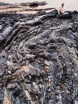
Figure 5: Syn-depositional slump fold at
Lai Chi Chong, northeast New Territories.
Folds - Plastic (Ductile) Deformation of Rocks
If the age succession of the folded rocks is not known, a convex upward fold, with limbs that converge upwards in an arch, is called an antiform, and a convex downwards fold, with limbs that converge downwards, is called a synform.
Where older rocks occupy the core of a fold, the fold is called an anticline, and where younger rocks occupy the core of a fold, the fold is called a syncline (Figure 6a). A fold with limbs that converge horizontally is called a recumbent fold.
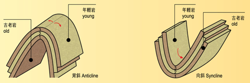
Figure 6a: Anticline and syncline.
Key aspects of the geometry of folds include the strike and dip of the axial surface (Figure 6b), and the trend and plunge of the hinge line (Figure 6c). The axial surface is an imaginary plane through the hinge line of the fold. The trend is the compass direction (azimuth) of the hinge line in the direction of plunge, and the plunge is the angle between the horizontal and the hinge line.

Figure 6b: Key elements of folds.
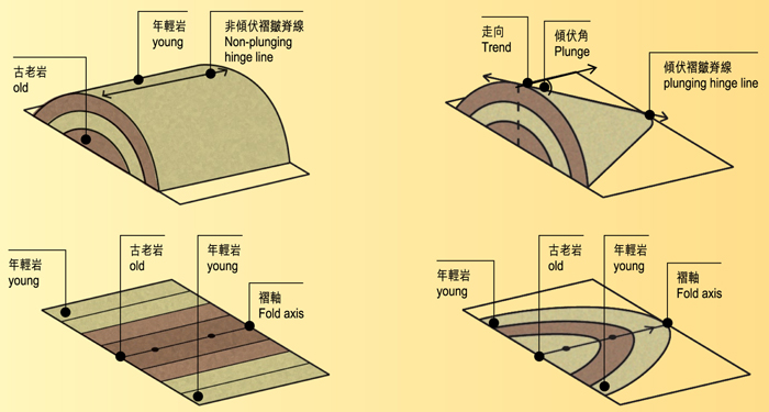
Figure 6c: Folds and outcrops patterns.
Not only do the orientation of folds vary, but the shape also varies. Folds may be symmetrical or asymmetrical (Figure 6d). Symmetrical folds have limbs of equal length, presenting two identical mirror images on each side of the axial surface, and asymmetrical folds have limbs of unequal length. It should be noted that, to definitively determine the symmetry of a fold, it is necessary to see the entire lengths of the limbs on both sides of the hinge.

Figure 6d: Types of folds.
Joints in Hong Kong
Joints are fractures or cracks in rocks along which there has been no detectable displacement. The shape and orientation of features such as cliff faces, tors, and boulders are controlled by the jointing pattern within the rock mass.
Joint patterns generally have a characteristic geometry and a regular spacing. They develop in three main modes, including tectonic joints, stress relief joints and cooling joints.
Tectonic Joints
Tectonic joints are associated with regional tectonic deformation, typically with the regional network of faults, or deformation associated with emplacement of plutons. They may be formed under shear or tension.
Tectonic joints associated with fault zones are generally very persistent in Hong Kong. They facilitate the infiltration of groundwater and the development of linear depressions in the rockhead.
Tectonic joints associated with igneous intrusions generally are more localised, forming impersistent discontinuities that peter-out away from the contact zones. Many thin aplite and pegmatite veins within country rock near the boundaries with granite intrusions probably infill tectonic joints that were formed at the time of pluton emplacement. Tectonic joints formed under tension generally have rougher surfaces that those formed under shear.
Stress Relief Joints
Stress relief joints develop in rocks close to the ground surface as a result of relaxation of confining pressure (overburden) following erosion of the overlying layers. If they are large scale and subparallel to the topography they are called sheeting joints. However, smaller scale curved or concentric joints, particularly those associated with development of corestones, are called exfoliation joints.
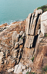
In Hong Kong, sheeting joints, especially those developed in granitic rocks, are commonly accompanied by at least two orthogonal, subvertical joint sets (Figure 7). Overall, the joint spacing in coarse-grained rocks, such as granite, is wider than in fine-grained rocks, such as tuff.
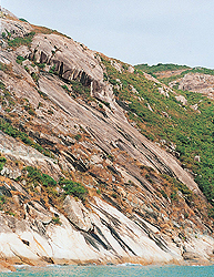
Stress relief joints in granitic rocks may be very persistent, extending for several hundreds of metres (Figure 8). On a local scale, they may facilitate the formation of exfoliation joints associated with corestone development.
Cooling Joints
Cooling joints develop as a result of cooling and contraction in granitic and volcanic rocks following their emplacement. They are typically perpendicular to the cooling surface and may form hexagonal columns.
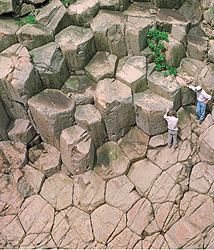
Columnar joints, up to 1.2 m in diameter, and up to 30 m tall, have developed in fine ash tuff of the High Island Formation (Figure 9). These hexagonal joints indicate that the tuff ponded in a large depression and cooled relatively slowly. Heat retained by the great thickness of the ash probably drove post-emplacement hydrothermal alteration processes.
Geological Structure and Landscapes
The rock structure has a profound influence on the landscape at all scales, from the regional-scale to the micro-scale:
The almost straight coastline of the South China Coast is controlled by the dominant regional fault pattern, which is aligned in a northeast to southwest direction. Similarly, the same northeast to southwest structures control the shape of the topography in Hong Kong (e.g. the Sha Tin Valley and the North Lantau coast) (Figure 10).
Locally, faulting and jointing patterns in the rock determine the orientation of minor valleys, the alignment of ridges, and the location of plains.
Within rock masses, the shape and orientation of features such as cliff faces, tors, and boulders are controlled by the jointing pattern in the rocks.
Within boulders, weathering produces a pattern of exfoliation shells and microfractures that develop parallel to the joint faces (Figure 11).
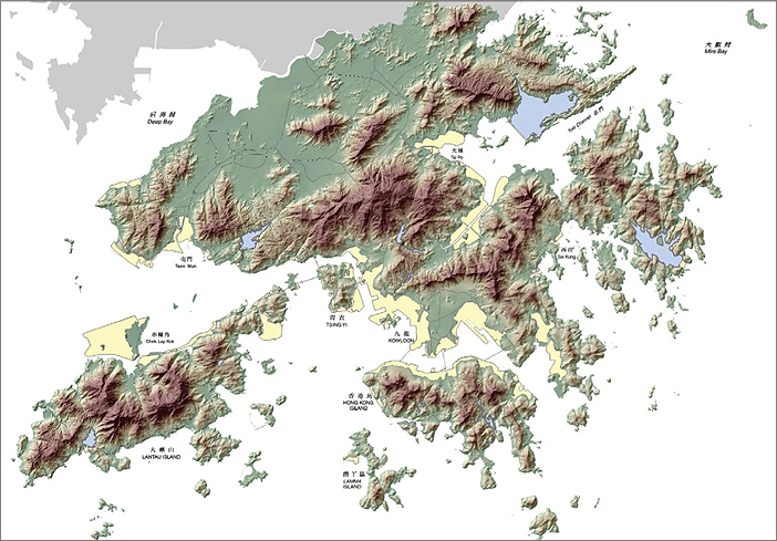
Careful examination of the Shaded Relief Map of Hong Kong (Figure 12) clearly shows how the topography of Hong Kong is controlled, at a variety of scales, by northeast to southwest and northwest to southeast structures, and to a lesser extent by north to south structures.
The overall shape of Hong Kong (such as the outlines of the bays, peninsulas and islands) and the details of structures (such as the shapes of individual rock outcrops) are controlled by the regional and local structures in the rocks.
Seismicity
There are no known active faults in Hong Kong.
Although Hong Kong is considered to lie in a region of low to moderate seismicity, it has not experienced a major earthquake during the historical period. Seismic activity in the region is generated mainly by the interaction between the Eurasian and Philippine plates.
The largest recorded earthquake close to Hong Kong was a magnitude 6.0 event in Honghai Bay, 85 km east of Hong Kong, in 1911.
