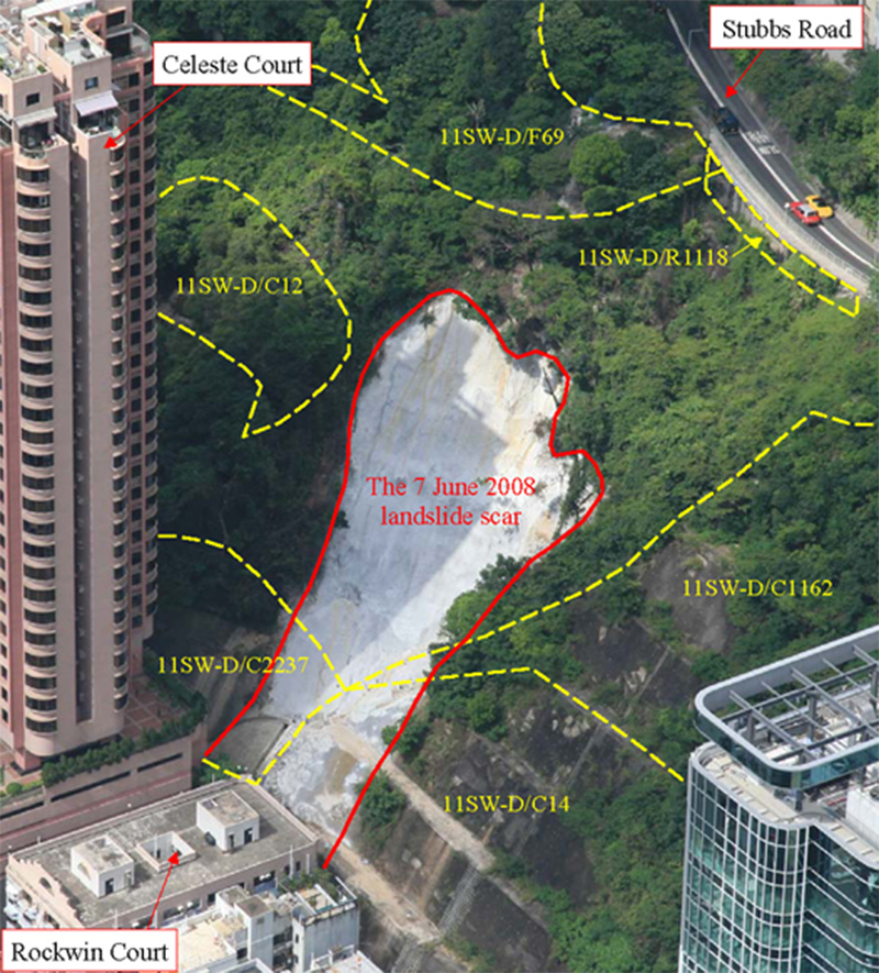
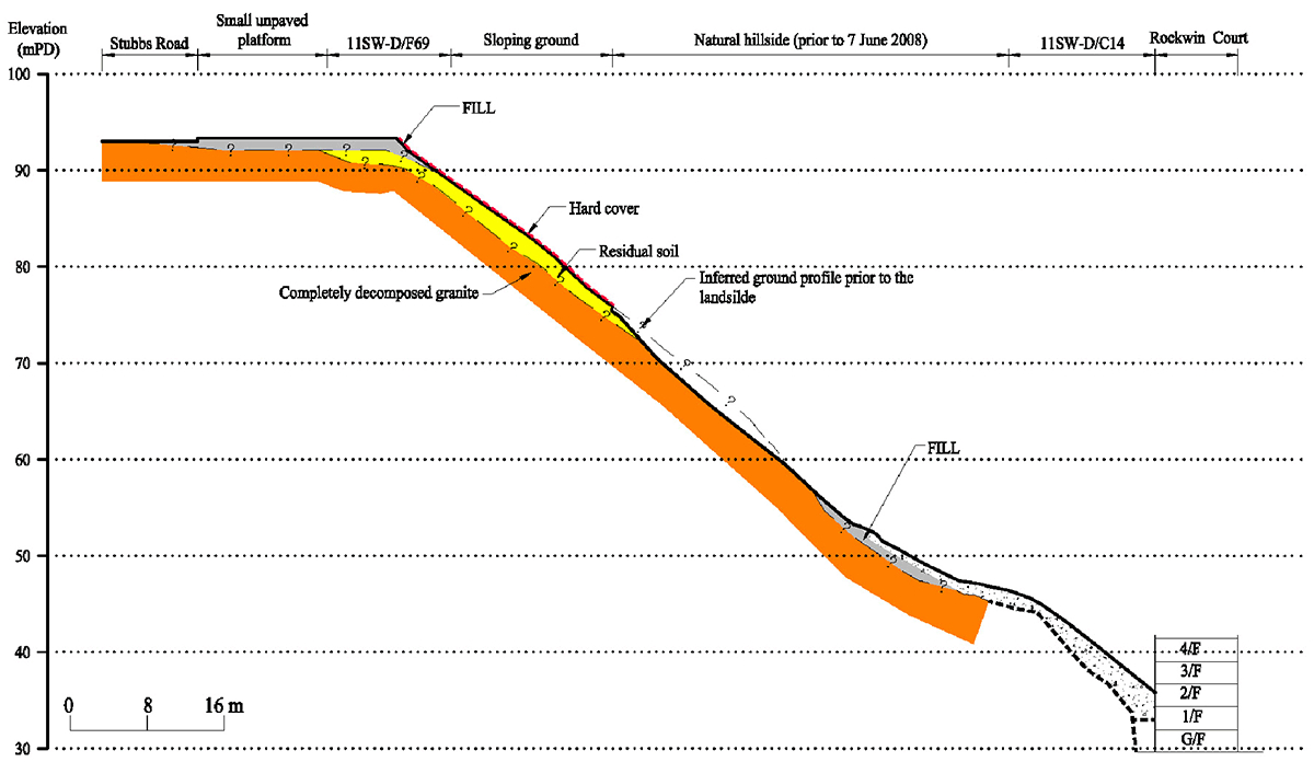
The 7 June 2008 Landslide behind Rockwin Court, Fung Fai Terrace, Happy Valley
Basic Data
Material:
Residual Soil
Feature Affected:
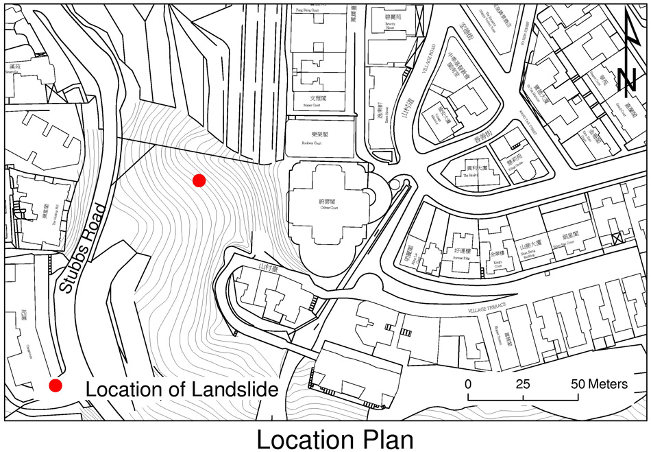
Hillside below Stubbs Road overlooking Rockwin Court, Fung Fai Terrace, Happy Valley
Volume:
500 m3
Report Reference:
GEO Report No. 285
Description
Between 8:45 a.m. and 9:30 a.m. on 7 June 2008, a major landslide with a failure volume of about 500 m3 occurred on the hillside overlooking Rockwin Court, Fung Fai Terrace, Happy Valley. The landslide was shallow (< 1.5m deep) involving a thin mantle of residual soil. The landslide debris travelled down the natural hillside with a runout distance of about 55 m and came to rest at the rear of Rockwin Court. There were no casualties as a result of the incident, however residents in nine affected flats of Rockwin Court were temporarily evacuated.
The landslide was probably caused by saturation of the near-surface groundmass and build-up of transient groundwater pressure within the groundmass. The natural hillside where the 7 June 2008 landslide occurred is steeply inclined at about 40 ¢X with no records of previous landslides. In addition, the sloping ground immediately above the landslide location is covered with a hard surface, which would have enhanced surface runoff towards the landslide site and promoted additional water ingress into the groundmass. Further water ingress from two possible sources, viz. the overflow from a blocked stepped channel at the northern flank of the landslide and the subsurface seepage flow from a small unpaved platform above the landslide, could also have contributed to the failure.
Observations
The landslide incident highlighted the potential landslide risk arising from hillside close to developments within urban areas, as well as the adverse impact of the surrounding man-made features on the hillside stability.
The 7 June 2008 Landslide Behind Ewan Court, Kennedy Road, Wanchai
Basic Data

Material:
Fill and Colluvium
Feature Affected:
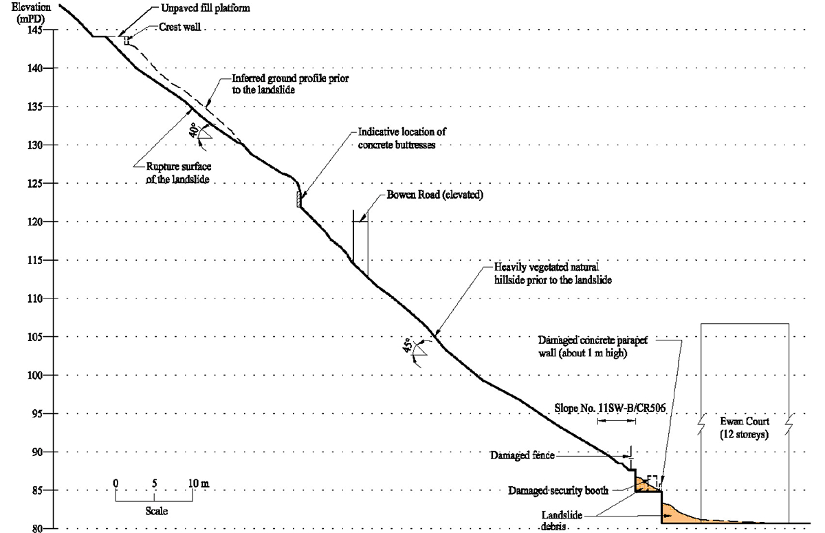
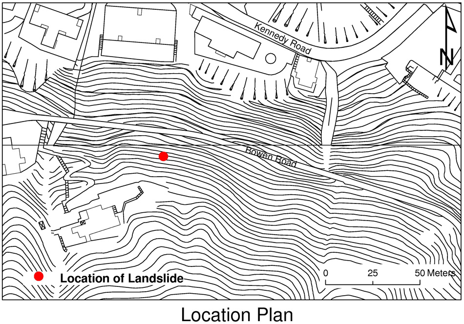
Natural hillside above Bowen Road and an unpaved fill platform at its crest
Volume:
200 m3
Report Reference:
GEO Report No. 278
Description
Between 7:00 a.m. and 7:30 a.m. on 7 June 2008, a landslide with a failure volume of about 200 m3 occurred on the hillside overlooking Ewan Court at Kennedy Road, Wanchai. The landslide mainly involved the natural hillside above Bowen Road and a portion of an unpaved fill platform at its crest. The landslide debris travelled down the natural hillside with a runout distance of about 80 m and came to rest at the rear alleyway of Ewan Court, damaging a security booth and a section of concrete parapet wall. There were no casualties as a result of the incident.
The landslide was probably caused by saturation of the near-surface groundmass and build-up of transient groundwater pressure in the groundmass following the rainfall. The hillside is steeply inclined at about 40° and has a history of past instability. Blockage of the inlet to a surface drainage channel at the western flank of the landslide and the presence of the unpaved fill platform could have resulted in additional water ingress into the groundmass.
Observations
The landslide incident highlighted the potential landslide risk of a steeply inclined hillside to nearby developments and the adverse impact of the surrounding man-made features on the hillside stability.
The 7 June 2008 Landslide on Slope No. 11SE-A/C502 at Pak Fuk Road, North Point
Basic Data

Material:
Residual soil / Completely decomposed granite
Feature Affected:
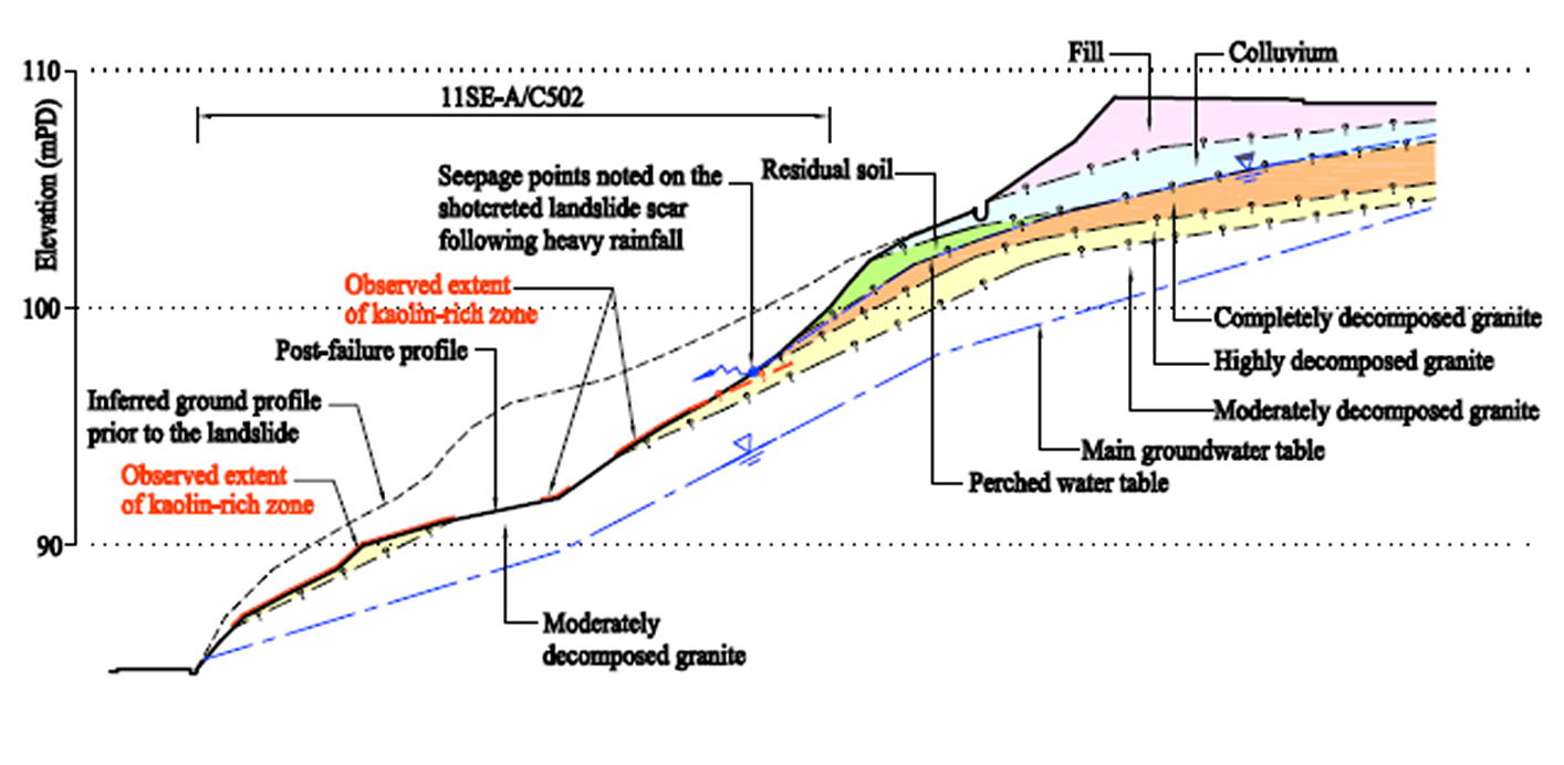
11SE-A/C502 at Pak Fuk Road, North Point
Volume:
1,270 m3
Report Reference:
GEO Report No. 289
Description
At around 8:40 a.m. on 7 June 2008, a major landslide with a failure volume of about 1,270 m3 occurred on a soil and rock cut slope No. 11SE-A/C502 at Pak Fuk Road, North Point. The landslide was shallow, involving a mantle of residual soil and completely decomposed granite. Many large boulders were contained in the debris. The landslide debris travelled down the slope with a runout distance of about 43 m and came to rest on Pak Fuk Road. There were no casualties as a result of the incident, however Pak Fuk Road was closed for 16 days.
The landslide occurred on a 15 m high unsupported cut slope formed at about 40°. The landslide was probably caused by saturation of the near-surface groundmass and build-up of transient groundwater pressure within the groundmass. At the location of the landslide, a kaolin-rich zone with adversely orientated kaolin infilled sheeting joints was encountered which would have adversely affected the mass strength of the groundmass. Transient perching of groundwater was apparent in the soil mantle with several observations of seepage flow in quick response to rainfall, including an active soil pipe in one of the trial pits close to the scarp. Moreover, slope No. 11SE-A/C502 has a history of instability with a large failure occurring in 1983 shortly after its formation and a minor failure in 2006. The previous failures serve to demonstrate that the slope was of marginal stability and possibly subject to progressive deterioration. A change in surface cover from hard surfacing to vegetation some time in the late 1990s may have further contributed to the failure by promoting infiltration into the groundmass.
Observations
The landslide incident highlights the potential landslide risk arising from the less robust nature of an engineered unsupported cut, which could have been more susceptible to large-scale failure due to the presence of weak geological features and unfavourable hydrogeological conditions.
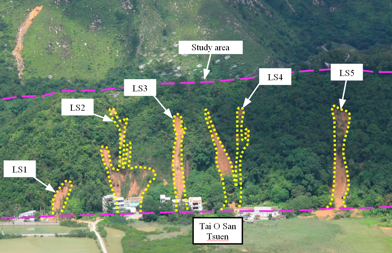
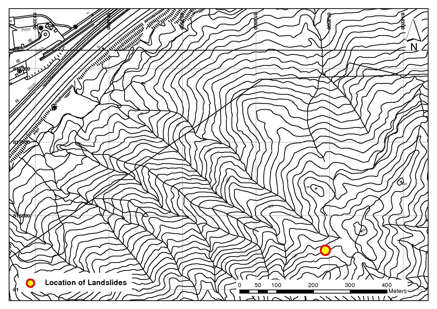
The 7 June 2008 Landslide Cluster on the Natural Hillside above Tai O San Tsuen, Tai O, Lantau Island
Basic Data
Material:
Colluvium & Decomposed Tuff
Feature Affected:
Natural hillside
Volume:
1,000 m3 (Total of five landslides)
Report Reference:
GEO Report No. 275
Description
A cluster of five open hillslope failures occurred on a hillside catchment above Tai O San Tsuen, Lantau, during the 7 June 2008 rainstorm. The landslide cluster involved 10 landslide source areas, with a debris volume generally less than 100 m3.
The subject hillside catchment is relatively small in size but the landslide density is very high, because the subject hillside is quite steep and would have undergone active coastal erosion processes.
The landslides were generally small and shallow (up to 2m deep). The rupture surfaces were largely within partially weathered rock and possibly joint-controlled. The landslides were not mobile with a travel angle of about 35°. However, as the landslide sources were not far up the hillside, the landslide debris travelled up to 80 m, affecting the houses at the toe of the hillside and caused much nuisance.
There is evidence of many previous landslides on the hillside. The June 2008 landslides were located close to or at these previous landslide scars. Tension cracks and open joints were also observed in some parts of the hillside. The hillside may have been subject to deterioration, and some of the landslides on 7 June 2008 could involve a retrogression of previous failures.
Observations
This incident highlights the potential landslide risk associated with natural hillside subject to progressive deterioration and reactivation of past instability.
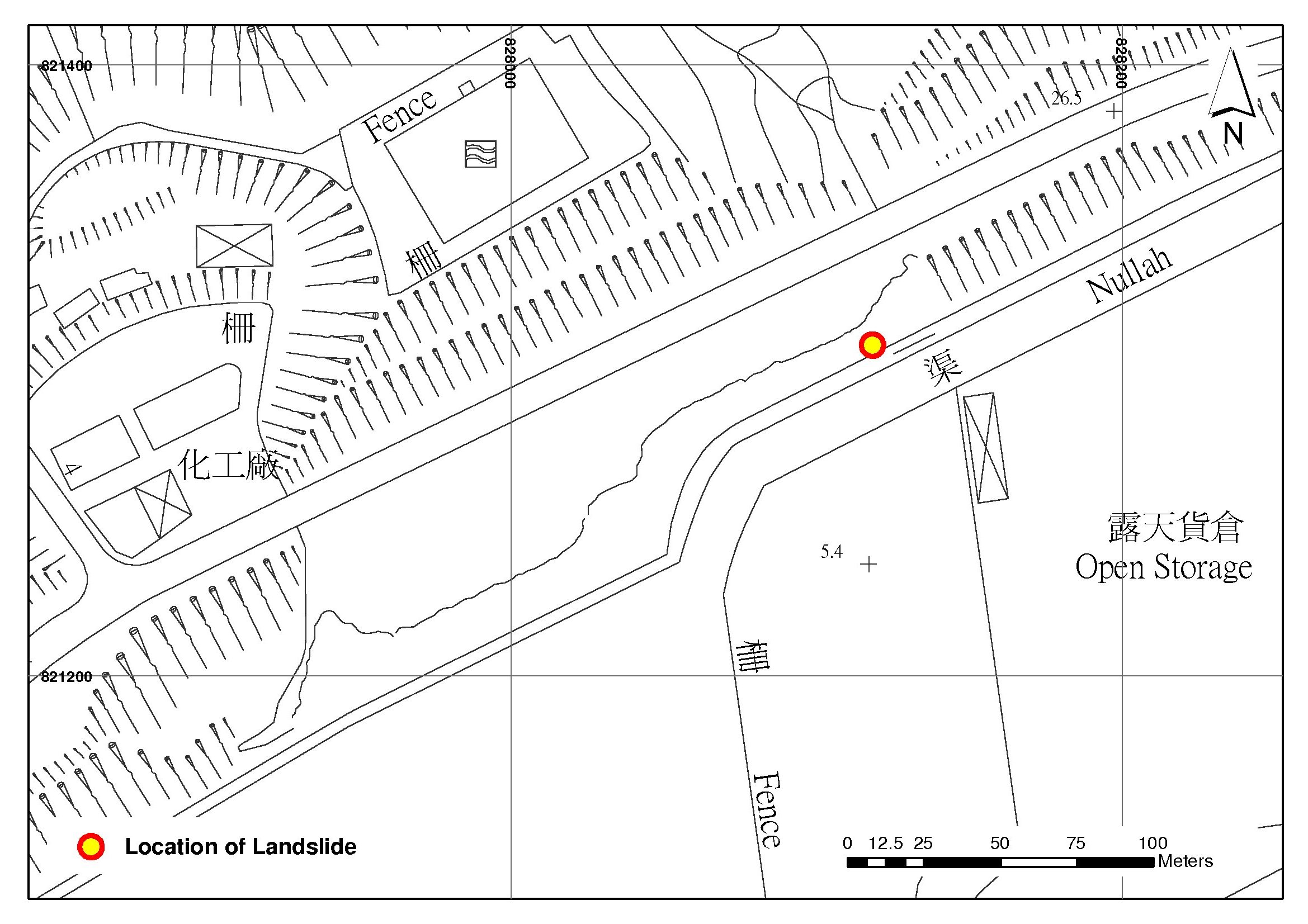
The 7 June 2008 Landslide Cluster on the Rock Slope Failure on Slope No. 10NE-B/C56, below Tsing Yi Road
Basic Data
Material:
Rock
Feature Affected:
10NE-B/C56
Volume:
250 m3
Report Reference:
GEO Report No. 288
Description
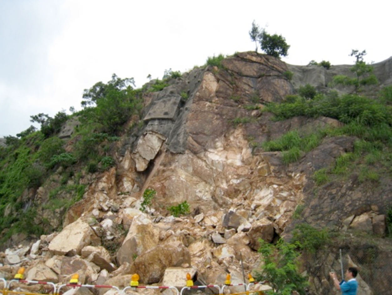
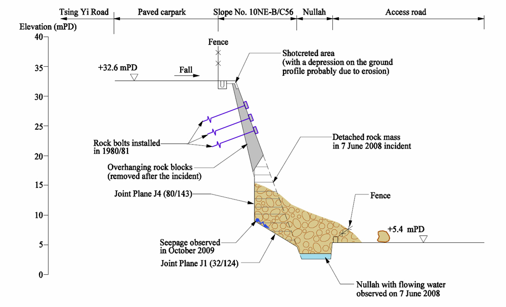
The 7 June 2008 landslide involved a 250 m3 failure on a rock slope No. 10NE-B/C56 below Tsing Yi Road. The landslide was probably rain-induced, due to adverse groundwater conditions, presence of adversely oriented rock joints and development of cleft pressures in the sub-vertical joint at the scarp of the landslide. Other factors that probably contributed to the failure include additional water ingress due to possible overspillage from a blocked crest channel, and slope deterioration.
The failure may have occurred in two stages. The main failure may have occurred as a translational slide with a large rock mass sliding along the basal slip surface. This would have resulted in loss of support to the overhanging rock wedge, and triggered a minor, secondary wedge failure.
The slope was stabilized in 1981 and was also subject to stability assessment in 1999. The critical joint which formed the basal slip surface of the 7 June 2008 failure was not identified in the past assessments.
Observations
This incident highlights the importance of conducting rock joint mapping in a diligent manner for rock slope assessments, as well as the importance of slope maintenance in ensuring good performance of a slope.
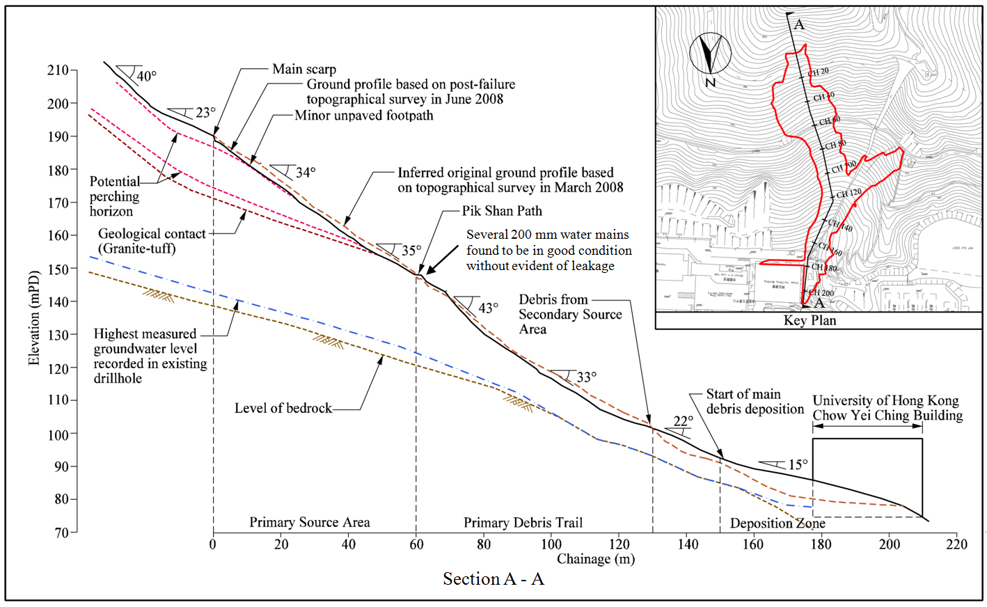
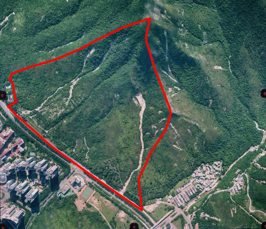
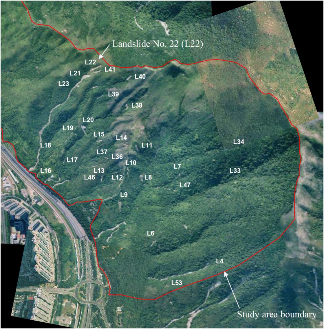
The 7 June 2008 Landslide on Natural Hillside behind Chow Yei Ching Building at the University of Hong Kong
Basic Data
Material:
Colluvium
Feature Affected:
Natural Hillside
Volume:
2,340 m3 (primary source area and its entrainment) + 400 m3 (secondary source area and its entrainment)
Report Reference:
GEO Report No. 276
Description
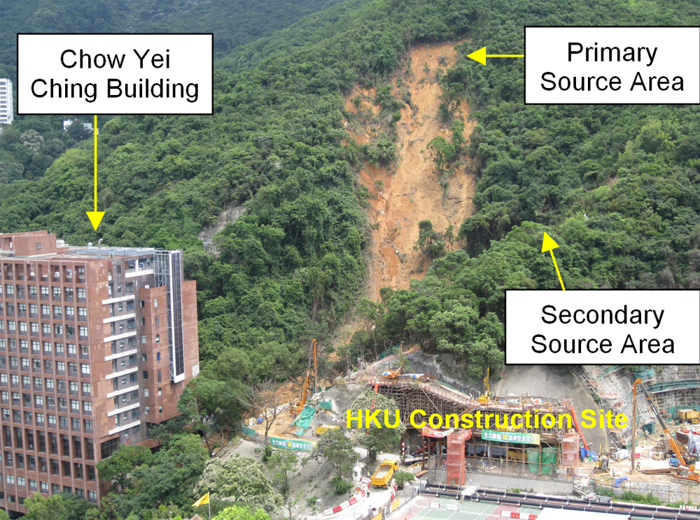
A massive landslide (2,740 m3), occurred on the hillside behind Chow Yei Ching (CYC) Building at the University of Hong Kong. The landslide involved a large primary source area (measured 60 m long and 42 m wide) and a smaller secondary source area. The landslide initiated as an open hillside failure becoming a channelized debris flow as the debris reached an emphemeral drainage line. The debris travelled for a total distance of about 210 m before coming to rest at the side of the CYC Building. The debris went into the lower floors and car park of the CYC Building, and some traveled further down to Pok Fu Lam Road and Bonham Road. No casualties were reported as a result of the landslide.
The landslide was probably triggered by the severe 7 June 2008 rainstorm which was the most intensive since 1978. It was shallow but spatially extensive, not typical of the previous landslides in the catchment.
Post-landslide investigation revealed the localised effects of the granite/tuff contact in the primary source area and a relatively steep-inclined broad topographical depression on the hillside catchment. This adverse geomorphological and geological setting has given rise to a history of failures that have resulted in accumulations of colluvial material within the broad topographical depression.
Progressive deterioration and deformation within the superficial colluvial accumulations was evident, which might have led to formation of tension cracks, and would have made the hillside vulnerable to further water ingress or infiltration.
Observations
This incident showed that past failures and adverse geological and geomophological settings on a hillside could have a significant implication to the scale and processes of the landslides in future. This also highlights the difficulty involved in natural terrain hazard study, especially in predicting large magnitude low-frequency events.
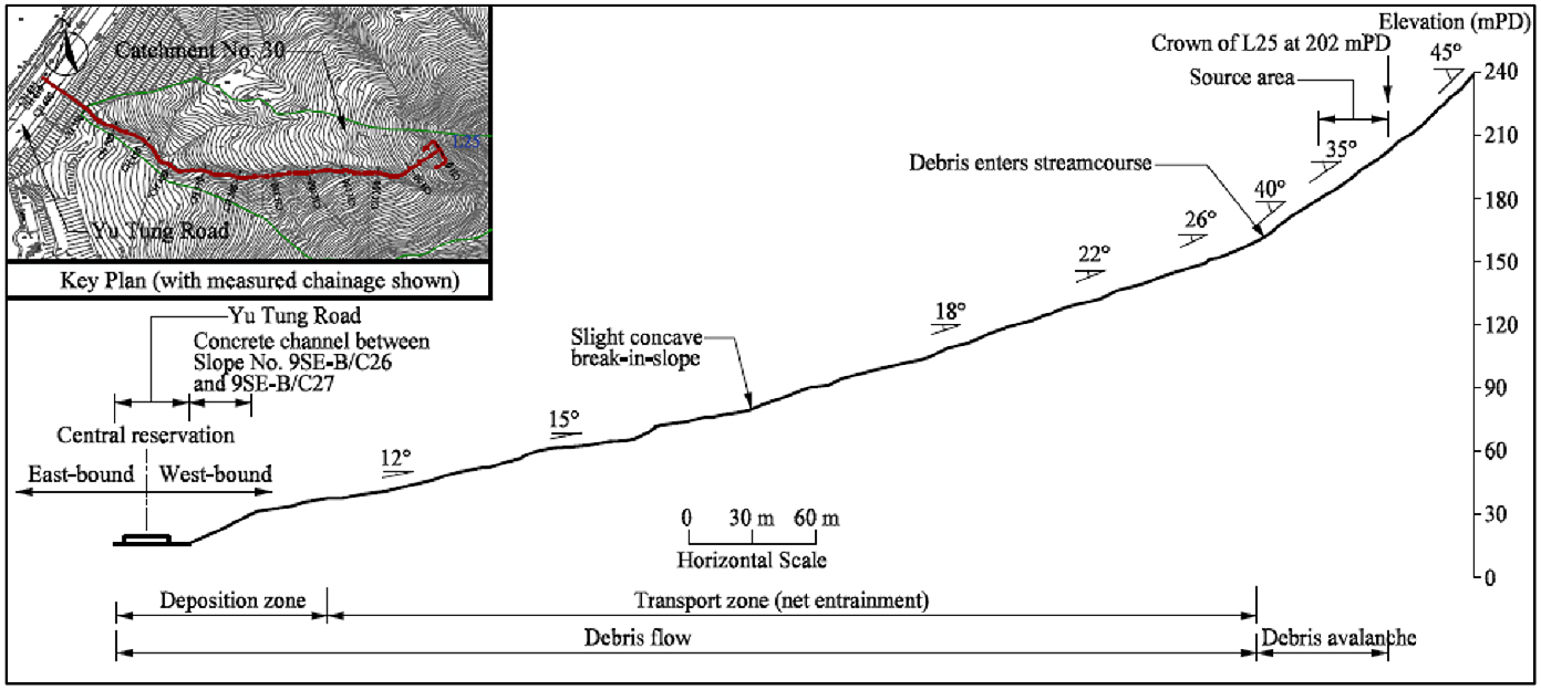
The 7 June 2008 Landslides on the Hillside above Yu Tung Road, Tung Chung
Basic Data
Material:
Colluvium
Feature Affected:
Natural Hillside
Volume:
2,350 m3 (at the southern catchment) + 150 m3 (at the northern catchment)
Report Reference:
GEO Report No. 271
Description
On 7 June 2008 during a Black Rainstorm, 19 landslides occurred on the natural hillside above Yu Tung Road, Tung Chung, Northern Lantau. Two of the landslides turned into major channelized debris flows (CDFs) in two catchments of the hillside (i.e. the northern and southern catchments). About 3,500 m3 of debris from the southern catchment reached Yu Tung Road while about 250 m3 of debris from the northern catchment deposited alongside Yu Tung Road. Subsequent outwash resulted in debris being carried onto the Tung Chung Eastern Interchange and flooding of Cheung Tung Road below. Closure of both westbound lanes for over two months was resulted. No casualties were reported.
The failures were probably triggered by intense rainfall. Some of the landslides were located at or close to past failure locations indicating that the possibility of reactivation or retrogression of previous failures could not be ruled out.
The largest landslide (i.e. with a failure volume of 2,350 m3 at the southern catchment) was shallow but spatially extensive, which is uncommon for natural terrain landslides in Hong Kong. The failure involved a large area of boulder deposits within a topographical depression. This may have influenced the extent of the landslide and be a potential geomorphological sign of possible large-scale landslide.
The two CDFs on the hillside were very mobile. The high debris mobility may be influenced by the volume of debris, drainage line characteristics and morphology, water content of the debris and rainfall characteristics. Also, the entrainment mainly involved loose materials previously perched on the drainage line. It is observed that the amount of perched material along a drainage line is dynamic and may change significantly after a rainstorm.
Observations
This incident highlights a very mobile channelized debris flow that caused severe impact to facilities at the toe. The impact from the boulders of CDFs and secondary outwash action shall be considered in a holistic manner in the design of the mitigation measures on natural terrain.
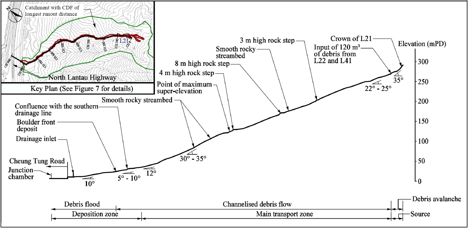
The 7 June 2008 Landslides on the Hillside above North Lantau Highway and Cheung Tung Road, North Lantau
Basic Data
Material:
Mostly colluvium and talluvium
Feature Affected:
Natural Hillside
Volume:
400 m3 (at source for channelised debris flow with the longest runout distance)
Report Reference:
GEO Report No. 272
Description
The severe 7 June 2008 rainstorm triggered 38 landslides on the hillside above the North Lantau Highway (NLH). Of the 38 landslides, four developed into channelised debris flows (CDFs). The runout distances of the CDFs ranged from 200 m to 735 m. The high debris mobility in the CDF with the longest runout distance is probably related to the relatively confined drainage line (with a channelization ratio < 7) and the rocky, smooth channel bed, coupled with the large catchment size (>100,000 m2). All the CDFs terminated within the drainage lines without reaching the toe of the hillside.
Debris floods may have occurred in three hillside catchments contributed to the severe flooding of Cheung Tung Road and the low-lying area at the adjacent NLH. In particular, the prolonged surging water flow, exacerbated by the merge of two significant drainage lines, turned the CDF with the longest runout distance into a debris flood. It brought some 200 m3 of the sediment/debris further downstream and resulted in the blockage of the drainage inlet at Cheung Tung Road and hence severe flooding.
Observations
The incident highlights a relatively mobile channelized debris flow and the subsequent outwash action which can generate a severe impact to the adjacent toe facilities.
For CDF hazards, the use of typical mitigation measures such as debris resisting barriers will help to contain the landslide debris from reaching the downstream facilities. While such measures are effective in mitigating the landslide risk to life, these would not be adequate in preventing the sediment-charged water from flowing further downstream and discharging into the land drainage system. If not properly dealt with, it could cause flooding in low-lying areas.
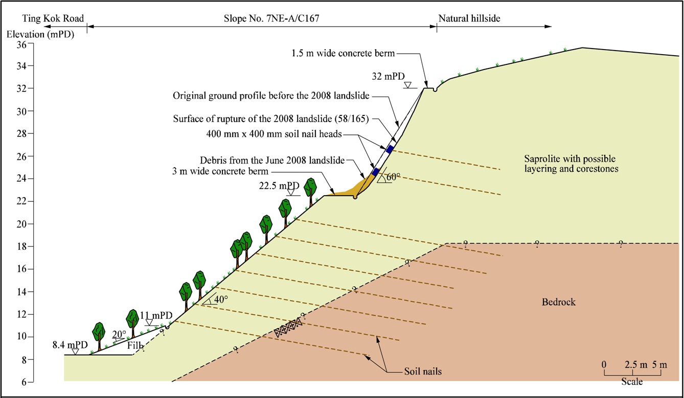
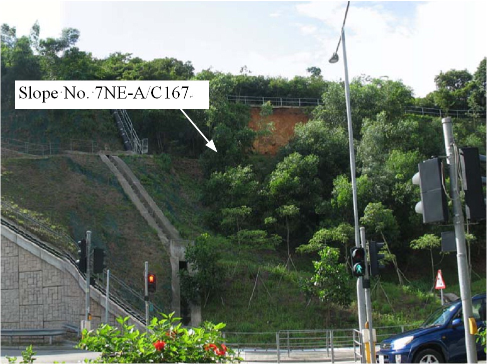
The June 2008 Landslide on Soil-nailed Slope No. 7NE-A/C167 at Ting Kok Road, Tai Po
Basic Data
Material:
Decomposed Granodiorite
Feature Affected:
Slope No. 7NE-A/C167
Volume:
20 m3
Report Reference:
GEO Report No. 295
Description
An incident involved a 20 m3 landslide failure on a steep, vegetated and soil-nailed cut slope No. 7NE-A/C167 at Ting Kok Road was reported on 12 June 2008. The landslide may have been triggered by saturation of the near surface of decomposed granodiorite (CDGr), during the rainstorm of 7 June 2008. The failure was shallow and it occurred on a 60° steep cut near the slope crest. Erosion control mat was provided on the slope surface prior to the failure.
The landslide debris was largely deposited on the berm immediately below the landslide scar or retained by the erosion control mat. Four soil nail heads were exposed on the scar. The landslide did not result in any casualties or road closure. The landslide involved a minor failure primarily due to local adversely oriented relict joint in the near surface groundmass, coupled with a steep slope profile. A 4 m high unsupported local portion near the crest of the slope could also have contributed to the failure.
The slope was stabilized with soil nails in 2006 under the Ting Kok Road Upgrading Project. The robustness of soil nails used in slope upgrading works has proven to be successful in preventing large scale instability in this case.
Observations
The incident highlights that occurrence of minor failures arising from local weak geological materials in the near surface groundmass is very difficult to guard against. Soil nailing layout should be arranged in such a way that the extent of unsupported steep cut on the slope is minimized. Moreover, the provision of surface protective measures such as the use of wire mesh or hard cover for steep slopes could have enhanced the local stability of the slope.