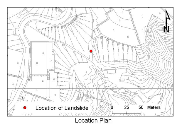
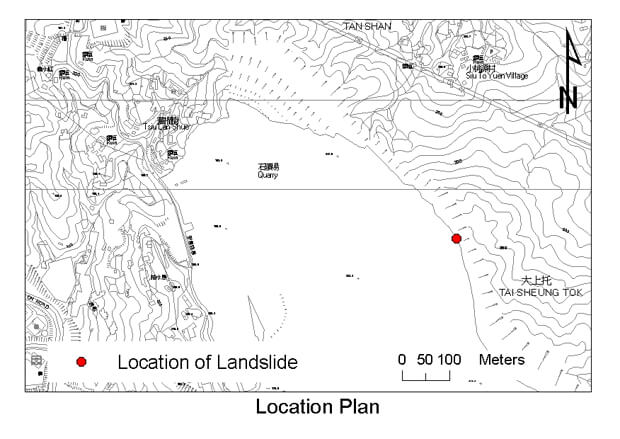
The August 2004 Landslide within Anderson Road Quarry, Sau Mau Ping
Basic Data
Material:
Completely Decomposed Tuff
Feature Affected:
Slope under construction
Volume:
6 m3
Report Reference:
LSR 8/2005
Description
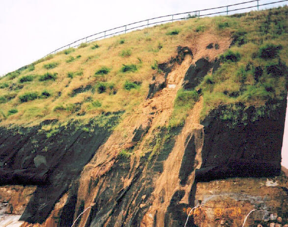
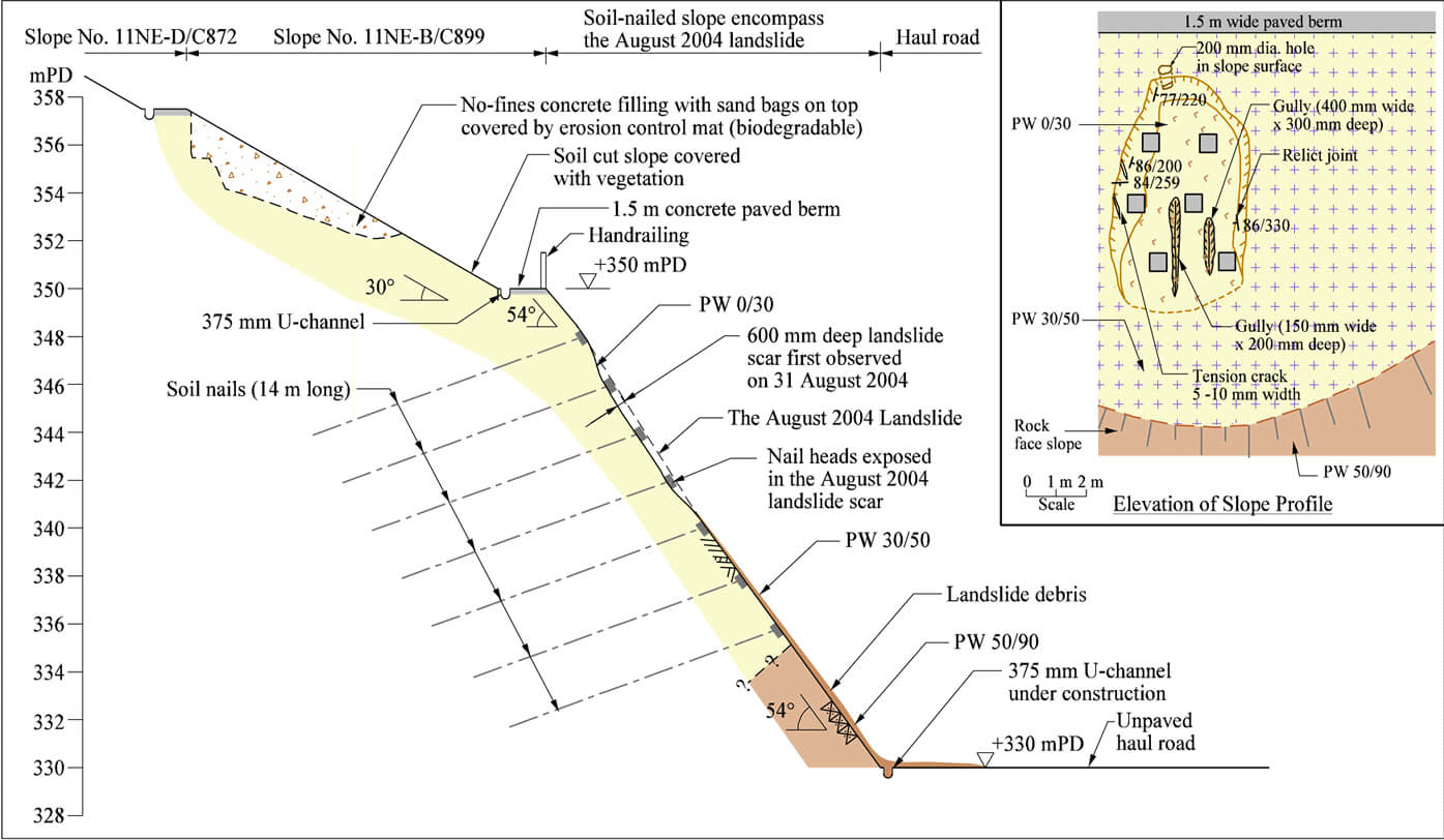
The landslide involved a shallow failure between soil nail heads on a 20 m high, newly formed, 54o soil/rock cut slope near the upper portion of the Anderson Road Quarry, where quarry rehabilitation works were on-going. The landslide debris was deposited on a haul road at the slope toe. No casualties were reported.
The landslide was triggered by moderate rainfall (with a return period of less than two years). The presence of adversely orientated relict joints in the failed area, which were not identified in the design stage, probably contributed to the failure. Signs of local slope distress and erosion were observed above the subject landslide on three occasions between mid-2000 and December 2003, which may indicate the presence of local adverse geological/ hydrogeological conditions.
The original geotechnical submission for the slope works was accepted by the GEO in November 1998. During the construction, the rockhead profile in the failed area was found to be about 20 m lower than that assumed in the original design. Design amendment, which proposed soil nailing to this area, was submitted to the GEO for checking in 2003. The amended geotechnical design was yet to be accepted by the GEO at the time of the landslide.
Following the observation of the signs of local distress and erosion of the slope between mid 2000 and 2003, remedial works were carried out by the contractor of the quarry rehabilitation works. The GEO District Division was not made aware of these observations and remedial works until after the occurrence of the August 2004 landslide.
Observations
This landslide highlights that shallow failures are liable to occur in the 'active zone' of the soil nailed slopes in between soil nail heads, due to the presence of steep and adversely orientated relict joints.
The incident also highlights the importance of documenting repeated 'minor' distress along with details of remedial works, to which attention should be drawn in the design review during construction stage.
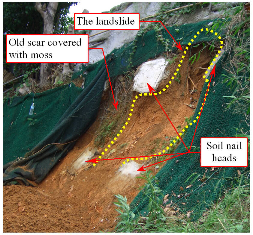
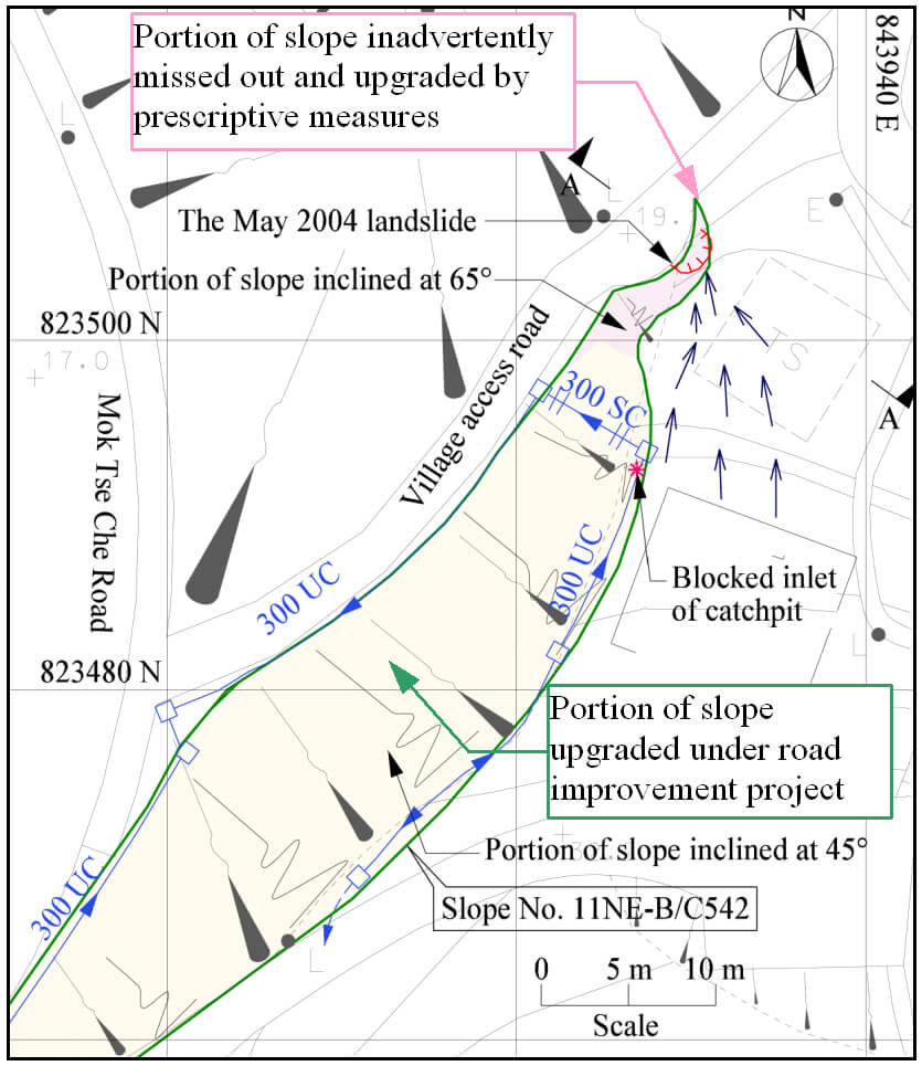
The 10 May 2004 Landslide at Slope No. 11NE-B/C542 at Mok Tse Che Road, Sai Kung
Basic Data
Material:
Colluvium and Saprolite
Feature Affected:
Cut slope No. 11NE-B/C542
Volume:
1 m3
Report Reference:
LSR 1/2005
Description
A minor landslide occurred on a vegetated 65o steep cut portion of a newly upgraded slope. The landslide involved shallow detachment of colluvium and saprolite between soil nail heads. No causalities or road closure were reported as a result of the incident.
The landslide was probably triggered by intense short-duration rainfall, which resulted in direct infiltration leading to the wetting up of the ground and loss of suction. The minor failure might have also been related to other contributory factors such as presence of a low point leading to concentrated surface runoff and infiltration towards the landslide source area, blockage of a catchpit at the slope crest providing additional source of surface water and the absent of a crest drainage channel above the failed portion to intercept surface runoff.
The slope portion involved in the failure was inadvertently missed out in the slope upgrading works under a road improvement project. The slope portion concerned was subsequently proposed to be upgraded by means of prescriptive soil nails with a vegetated cover protected by erosion control mat and wire mesh netting, together with a crest drainage channel. Post landslide inspection revealed that installation of wire mesh netting and construction of crest drainage channel had yet been carried out.
Observations
The incident highlights the importance of adequate attention to detailing of slope drainage measures and surface protection provisions. It is desirable to implement slope upgrading works for a slope in one single action, particularly for protective components such as surface drainage measures and slope protection.
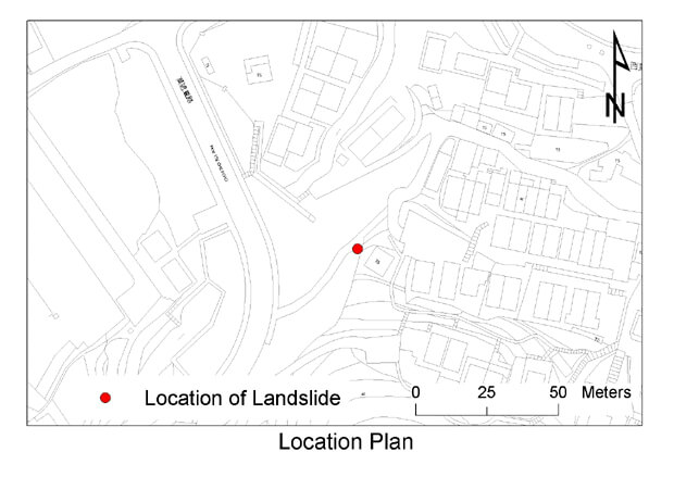
The August 2004 Landslide Incident Below Tseung Kwan O Chinese Permanent Cemetery, Yau Tong
Basic Data
Material:
Fill
Feature Affected:
Fill Slopes Nos. 11SE-B/FR151, 11SE-B/FR152 and 11SE-B/FR153
Volume:
350 m3
Report Reference:
LSR 9/2005
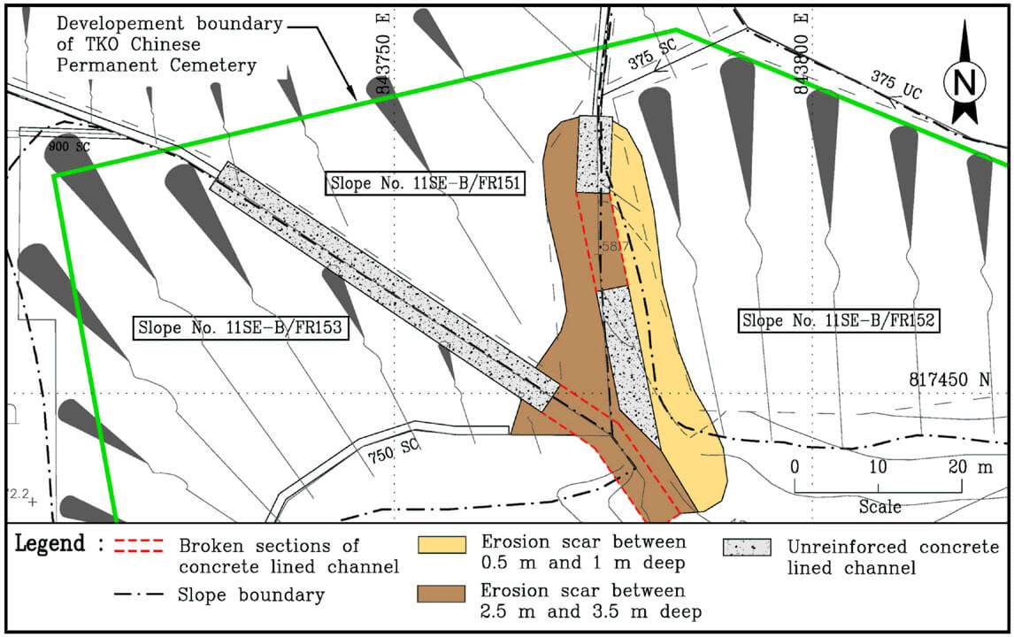
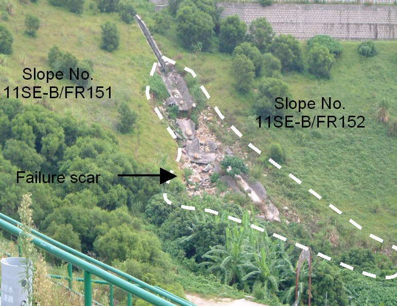
Description
A major washout failure along a shallow concrete-lined drainage channel between two unauthorised fill slopes (Nos. 11SE-B/FR151 and 11SE-B/FR152) and affecting another unauthorised fill slope (No. 11SE-B/FR153) below Tseung Kwan O (TKO) Chinese Permanent Cemetery was reported to the GEO in August 2004. The exact timing of occurrence of the washout failure is unknown. No casualties were reported.
The three slopes were formed largely on government land between 1997 and 2000 by filling across two existing natural drainage lines during the course of the Phase 4 Development of TKO Chinese Permanent Cemetery.
The lower portion of slope No. 11SE-B/FR151 and majority of slopes Nos. 11SE-B/FR152 and 11SE-B/FR153 have been formed outside the development boundary for the cemetery and none of these fill slopes were identified on the approved site formation plans for the private development. The unauthorised earthworks, which had an estimated volume of about 23,000 m3, were identified by the GEO some four years after the completion of site formation works. The unauthorised earthworks were not previously reported by the qualified site supervision personnel (Cat. I and Cat. III), and were not identified during site audits.
The incident was related to erosion probably caused by concentrated surface water flow as a result of water overtopping the concrete drainage channel at a change in channel alignment, where the depth of channel appears to be insufficient to prevent overtopping.
Observations
This landslide incident points to the need for properly designed surface drainage provisions and problems associated with unauthorised earthworks.