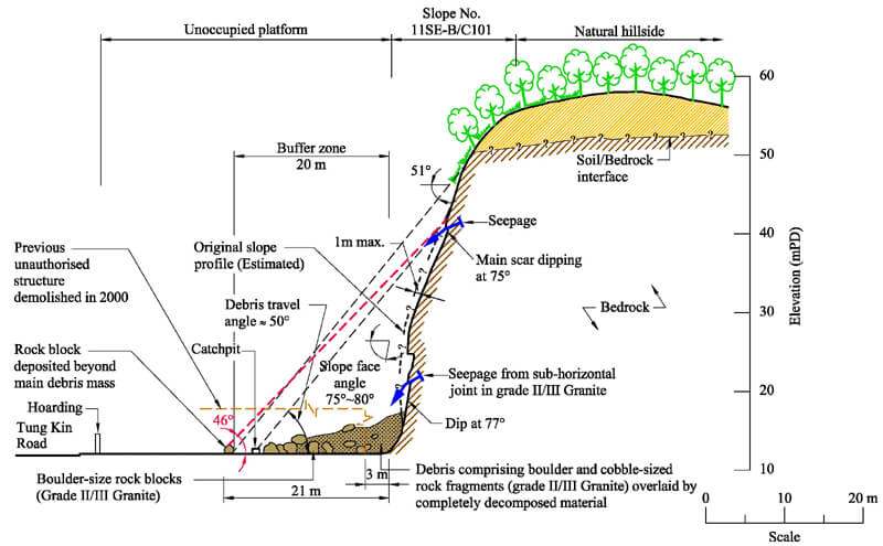
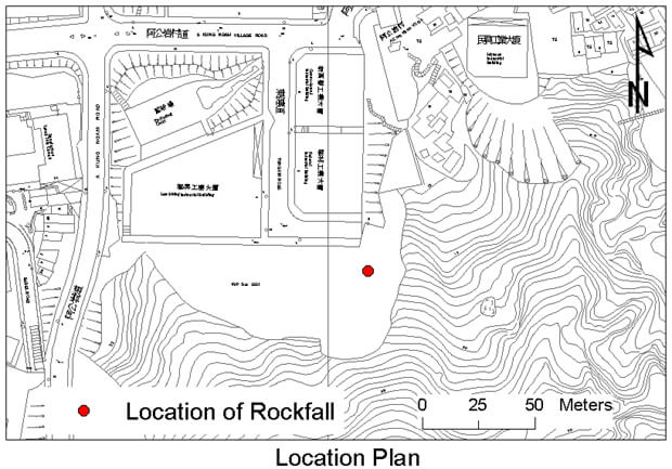
The 6 June 2003 Rockfall Incident at Tung Kin Road, A Kung Ngam
Basic Data
Material:
Slightly to Moderately Decomposed Granite
Feature Affected:
Cut slope No. 11SE-B/C101
Volume:
70 m3 (rockfall)
Report Reference:
Review of the June and August 2003 Rockfall Incidents on Slope No. 11SE-B/C101 at Tung Kin Road, A Kung Ngam
Description
The major rockfall occurred during moderate rainfall at the central portion of a 170 m long, 50 m to 60 m high, old soil/rock cut, which has a history of failures. The rockfall debris came to rest within the fenced-off open area at the slope toe, which was previously occupied by the tenants of two Short Term Tenancies (STTs).
The STTs were granted in 1991 with a term of three years, and a 20 m wide buffer zone (i.e. no-build area) in front of the slope based on slope safety consideration. Unauthorised structures were erected by the STT tenants within the buffer zone, who repeatedly ignored DLO's written demands between September 1993 and August 1994 to remove the unauthorized structures. Following a rockfall in July 1994, DLO terminated the two STTs in August 1994. However, the ex-STT tenants opted to stay put. Repeated advice was given by the GEO to DLO and the Eastern District Council on the need to vacate the structures on slope safety grounds. Eventually, the ex-STT tenants vacated the structures and were relocated in November 2000. The long time taken to resolve the land administration issues is highly undesirable from a slope safety point of view.
Observations
The sizeable old cut slope was known to be in a poor condition and vulnerable to landslides. However, it is not easy to predict with confidence the scale, location and timing of potential failures as there are many uncertainties involved. It was fortuitous that the major rockfall only occurred some time after all the building structures in front of the slope toe had been cleared, as otherwise the consequence of the June 2003 rockfall could have been very serious. This case serves as a vivid reminder of the pressing need to resolve land administration problems promptly in the interest of public safety where there is concern about potential slope instability.
The maximum runout of the rockfall debris of the June 2003 failure, which occurred at about two-thirds of the height of the cut, was beyond the previous buffer zone, although the majority of the debris was deposited within the buffer zone. Had the failure occurred higher up the cut slope or had it been of a larger scale, the runout of the debris would have been even further away from the slope toe. This highlights the uncertainty involved in assigning the appropriate extent of a buffer zone for landslide risk mitigation.
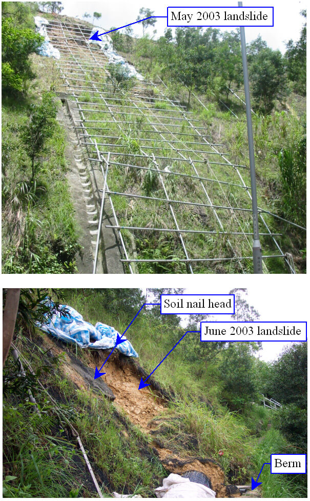
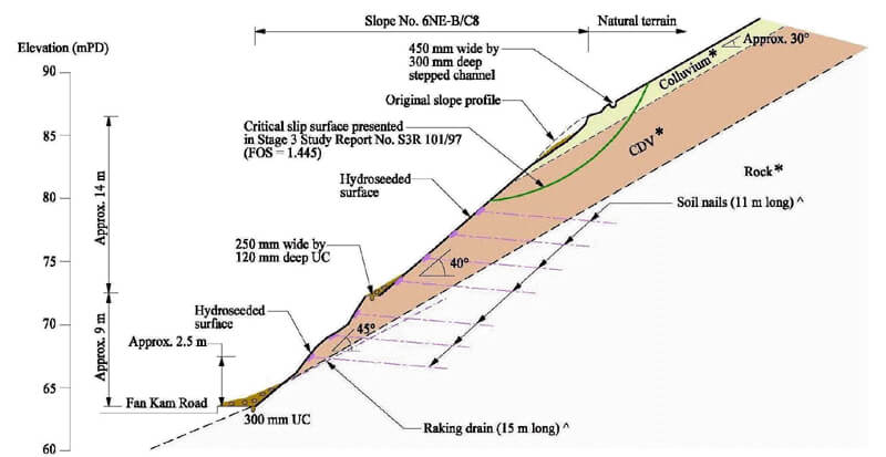
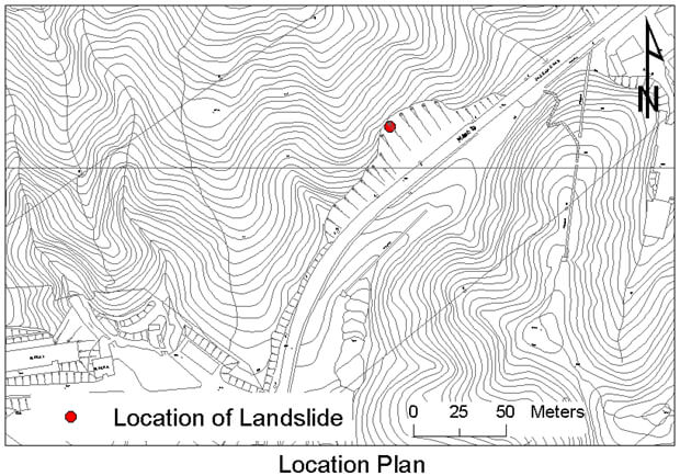
The 5 May 2003 and 13 June 2003 Landslides at Fan Kam Road, Pat Heung
Basic Data
Material:
Colluvium / Completely Decomposed Tuff
Feature Affected:
Cut slope No. 6NE-B/C8
Volume:
20 m3 and 3 m3
Report Reference:
GEO Report No. 190
Description
Two minor landslides occurred on an engineered cut slope (max. 23 m high) in May 2003 and June 2003 respectively, about three years after completion of slope upgrading works (which comprised installation of soil nails except for the uppermost 7 m of the soil cut) under the LPM Programme. One lane of Fan Kam Road was temporarily closed as a result of the May 2003 landslide. No casualties were reported.
The 5 May 2003 landslide (20 m3) occurred during intense short-duration rainfall involved the surface mantle of colluvium, in the upper unsupported cut portion. The failure was probably caused by the build-up of transient perched water table above the colluvium/saprolite interface. As part of the slope upgrading works. The existing shotcrete cover was removed and replaced with a vegetated cover. The removal of the existing hard cover might have promoted direct infiltration into the slope.
In the slope stability assessment in the design of slope upgrading works, the upper 7 m of the 40° steep soil cut slope was considered to be adequately stable based on stability analyses. The more critical slip surface involving shallow failure in the colluvium was not considered.
The June 2003 landslide (3 m3) involved a shallow detachment of saprolite in between soil nail heads at mid-slope portion during a moderate rainfall. The landslide occurred on a locally over-steep (50° to 55°) portion of the cut slope. This local failure was probably caused by direct infiltration leading to the wetting up of the near-surface material and loss of suction.
Observations
The May 2003 failure serves to highlight the importance of providing sufficient engineering input in examining the results of stability analysis.
The June 2003 failure serves to highlight the importance of identifying local oversteepening on slope and assessing the need of local trimming works.
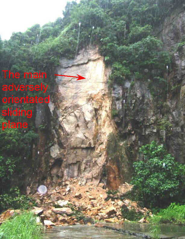
The 5 May 2003 Debris Flow at Kau Lung Hang Shan, Tai Po
Basic Data
Material:
Colluvium / Decomposed Tuff
Feature Affected:
Natural Hillside
Volume:
200 m3
Report Reference:
Review of the 5 May 2003 Debris Flow at Kau Lung Hang Shan, Tai Po
Description
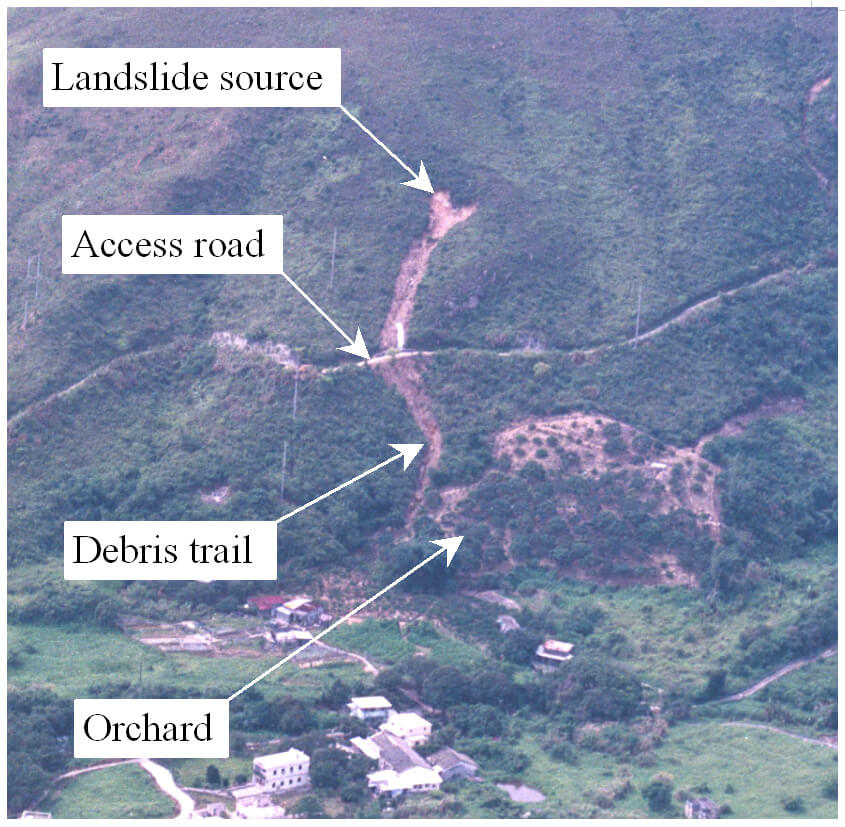
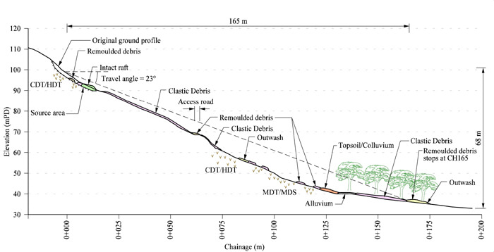
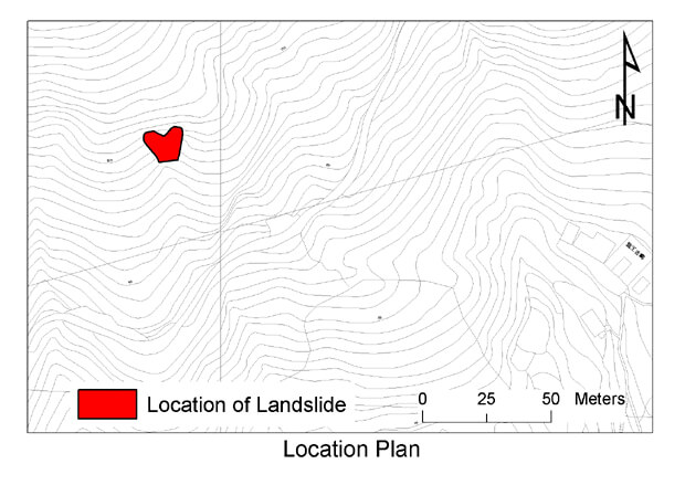
The landslide occurred at the head of a natural drainage line and below a break in slope and some rock outcrops on the hillside north of Kau Lung Hang Village. The debris was channelised down an ephemeral drainage line and deposited on a sole access road to Cloudy Hill Transmitter Station and on an orchard at the toe of the hillside. The landslide debris completely blocked the access road for four days and severed a chain-link fence of the orchard.
The landslide was triggered by a short-duration intense rainfall. The landslide partly involved planar sliding along the interface of colluvium/weathered tuff and partly along an adversely orientated (about 40°) sheeting joint in the weathered tuff. The failure was probably caused by the development of transient groundwater pressure due to surface infiltration. The travel angle and runout distance of the debris flow, disregarding the fluvial outwash, were about 23o and 165 m respectively.
There is no record of any past landslide in the vicinity of the landslide in both the NTLI (based on high-level aerial photographs) or GEO's Large Landslides Database. However, API using low-level aerial photographs revealed that the May 2003 landslide occurred within a relict landslide scar. Colluvial fans were also observed at the base of the subject natural drainage line and other adjacent drainage lines.
Observations
The incident provides a useful case history to assist in improving the understanding of the nature and mechanisms of natural terrain failures and assessment of hillside susceptibility. Also, it serves as a reminder of the potential uncertainty in assessing the susceptibility of a hillside based on NTLI alone.
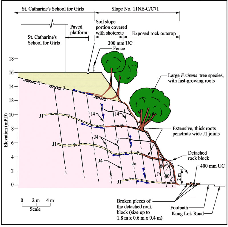
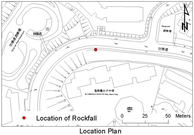
The 6 June 2003 Rockfall Incident at Kung Lok Road, Kwun Tong
Basic Data
Material:
Moderately Decomposed Granite
Feature Affected:
Cut slope No. 11NE-C/C71
Volume:
1 m3
Report Reference:
GEO Report No. 192
Description
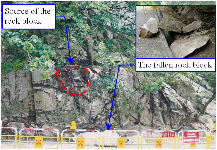
The rockfall occurred during a relatively light rainfall on an old, non-engineered, rock/soil cut slope (max. 22 m high), which has a history of failure. The rock block broke up into several pieces and came to rest on the pedestrian pavement at the slope toe. No casualties were reported.
The detachment was rain induced and was probably caused by water ingress into dilated sub-vertical rock joints, resulting in possible build-up of local cleft water pressure. A combination of local adverse joints, unfavourable groundwater condition and rapid growth of undesirable vegetation together with progressive deterioration of the slope condition probably played a key role in this rockfall.
The slope has been subjected to regular maintenance since about 2000. Subsequent to an Advisory Letter to the owners in 2000, an EI was carried out for the subject slope. It is noted that the slope maintenance works recommended by the EI were essentially indicative and not specified in detail, probably because of lack of safe access. No protective measures, such as rock mesh netting, and no specific maintenance requirement were recommended by the EI to account for the likelihood of progressive deterioration.
Observations
The trees involved in the June 2003 rockfall have strong and spreading root systems which are also fast-growing. Also, the presence of thick and persistent weathered joint seams (up to 250 mm thick) on the slope would promote the development of penetrative root system.
The rockfall serves to highlights the importance of providing proper attention to deal with unplanned/undesirable vegetation. It also points to the need to adopt robust measures in slope upgrading and enhanced maintenance works to prevent localised small-scale instabilities which could potentially have serious consequences.
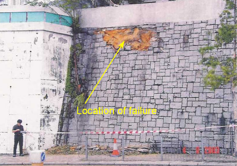
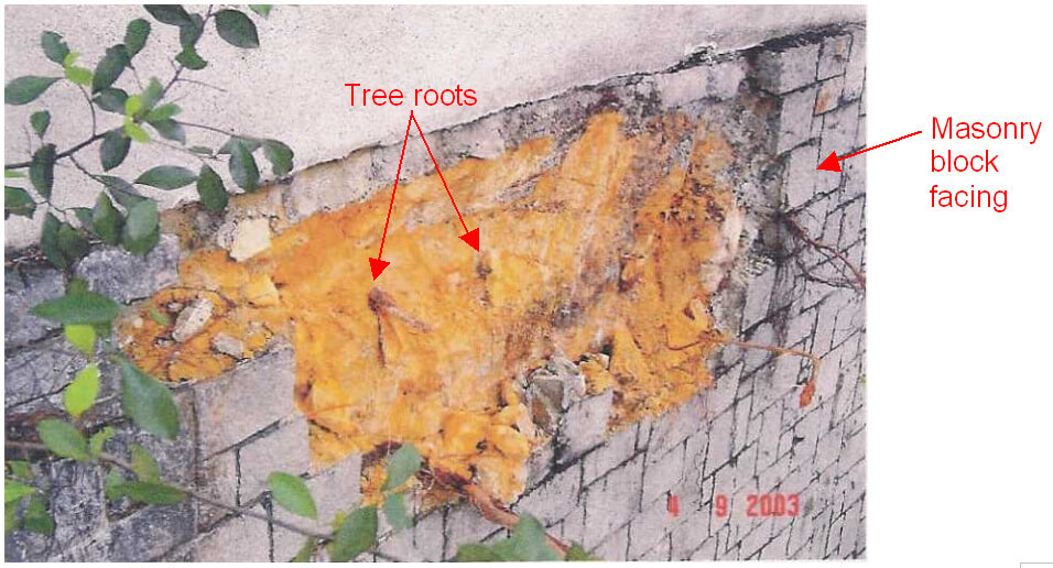
The 2 September 2003 Landslide at Lai Sing Court, Tai Hang Road
Basic Data
Material:
Stone-pitching Blocks
Feature Affected:
Cut slope No. 11SE-A/C897
Volume:
about 1 m3
Report Reference:
Review of the 2 September 2003 Incident on Feature No. 11SE-A/R51 at Lai Sing Court, Tai Hang Road
Description
The incident involved the detachment of several stone-pitching blocks at about noon from the crest of a 5.5 m high registered feature due to failure of an unplanned tree. The debris was deposited on the pedestrian pavement at the toe of the slope. No casualties were reported as a result of the incident.
The feature was formed in the late 1960's under a private development project. According to the BOO Approved Plans, the feature is a "76o ROCK CUTTING SLOPE". The feature was registered as a "concrete wall with masonry facing" in the 1977/78 Catalogue of Slopes. It was subsequently taken as a wall of "dressed block" in the Feature Registration Form of SIRST. The materials exposed at failure scar indicate that the feature is likely to be a cut slope with a thin masonry facing of 150 mm to 250 mm in thickness.
According to the Slope Information System (SIS), information on the thickness of the masonry blocks of the feature was unavailable. The CNPCS score for this registered feature was 0.96, which was based on an assumed 'average' wall slenderness ratio of between 2.8 and 3.5 in the NPCS scoring sheet, corresponding in this instance to a wall thickness of between 1.6 m and 2 m.
Following the incident, the subject feature is re-registered as Slope No. 11SE-A/C897 in the Slope Catalogue.
Observations
This incident serves to highlight the potential hazard of undesirable tree growth, which can lead to detachment of hard surface covers to steep slopes. This incident also points to the importance of having correct registration details in the Slope Catalogue.
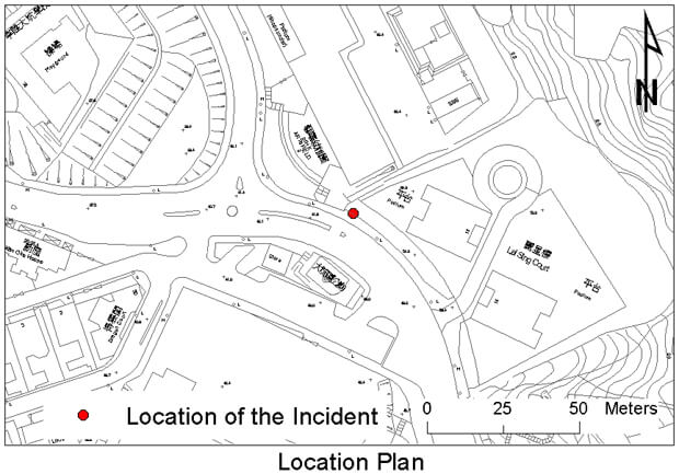
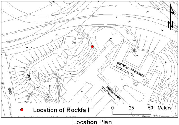
The 11 June 2003 Rockfall at Rehab Path, Kwun Tong
Basic Data
Material:
Moderately Decomposed Granite
Feature Affected:
Cut slope No. 11NE-D/C373
Volume:
15 m3
Report Reference:
Review of the 11 June 2003 Rockfall on Slope No. 11NE D/C373 behind a Temple at Rehab Path, Kwun Tong
Description
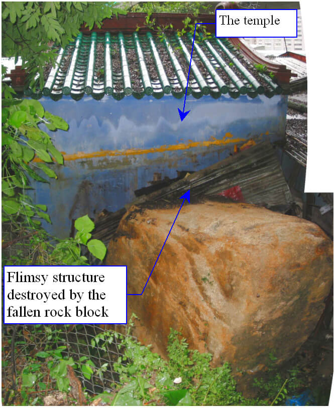
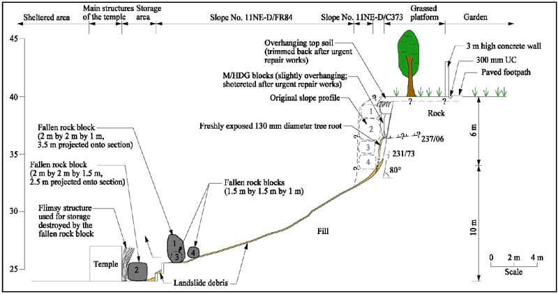
A rockfall (15 m3) occurred under moderate rainfall on the private portion of an old, non-engineered, soil/rock cut slope (max. 10 m high), which is of mixed maintenance responsibility (MR) and has a history of failures. An unauthorised and unoccupied flimsy structure at the slope toe behind a temple was destroyed in this incident. No casualties were reported.
Post-failure inspection revealed signs of significant deterioration/distress at the source area of the rockfall. Dilated rock joints, some partly infilled, were exposed, which would have allowed rapid water ingress.
Progressive deterioration of the slope condition associated with lack of maintenance probably played a key role in the June 2003 rockfall. This is illustrated by the partly infilled, dilated rock joints, the presence of undesirable vegetation growth in the joints resulting in jacking action on the rock blocks, and the fact that the failure occurred during only relatively moderate rainfall.
The slope has a history of failures. In addition, signs of distress on rock portion in the vicinity of the source of the June 2003 rockfall were observed by various parties including SIRST consultant, EI consultant and Stage 2 consultant between mid-1990s and early 2000s.
Although the GEO has been promoting maintenance of privately owned slopes by the private owners, the owners of the private slope portion in this instance did not arrange for any routine maintenance.
Observations
This incident serves to highlight the importance of regular maintenance on slope safety, which might have helped to prevent the June 2003 rockfall.
This rockfall also highlights the need to take prompt action to alert the responsible parties if significant signs of distress are identified.
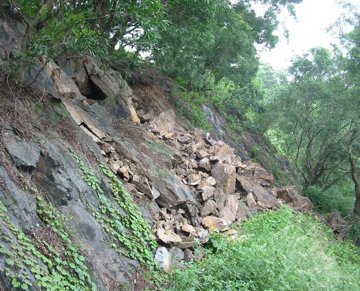
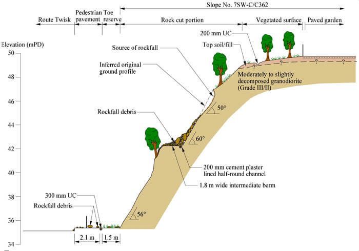
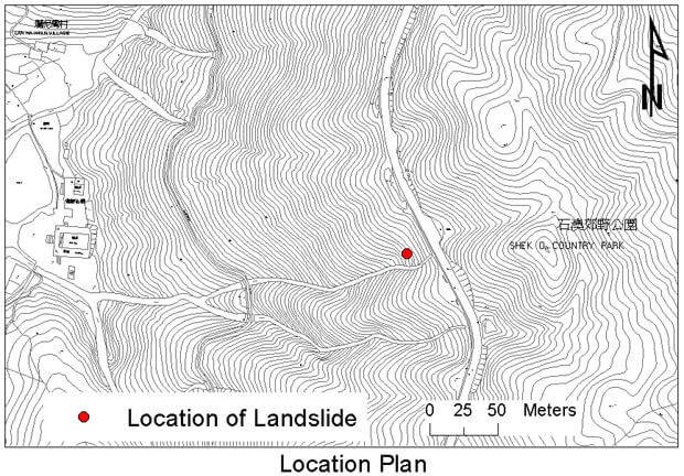
The 25 August 2003 Rockfall on Slope No. 7SW-C/C362 at Route Twisk near Tsuen Kam Interchange, Tsuen Wan
Basic Data
Material:
Moderate Decomposed Granodiorite
Feature Affected:
Cut slope No. 7SW-C/C362
Volume:
16 m3
Report Reference:
GEO Report No. 200
Description
This rockfall involved the detachment and displacement of a total of 16 m3 of rock blocks /soil debris along a steep rock joint (50°) on an engineered soil/rock cut. A portion of the debris was deposited on the pedestrian pavement at the slope toe. No causalities or road closure were reported as a result of the incident.
The rockfall was probably triggered by rainfall, with water ingress into a potentially dilated, adversely dipping rock joint resulting in the build-up of transient cleft water pressure behind the rock blocks. Tree root jacking action arising from unplanned vegetation may also have been a contributory factor in the failures.
The dominant adverse joint involved in the rockfall was apparently a local joint set, which could not be identified from mapping of the remaining rock exposures of the subject slope.
Observations
This incident highlights the uncertainty associated with possible local adverse features, which can be difficult to detect in practice and guard against in design. Given the uncertainty of the possible presence of local adverse ground and/or groundwater conditions, pragmatic measures such as provision of rock mesh netting, prescriptive rock dowels of nominal length, chain link fence at slope toe, etc. should be provided.
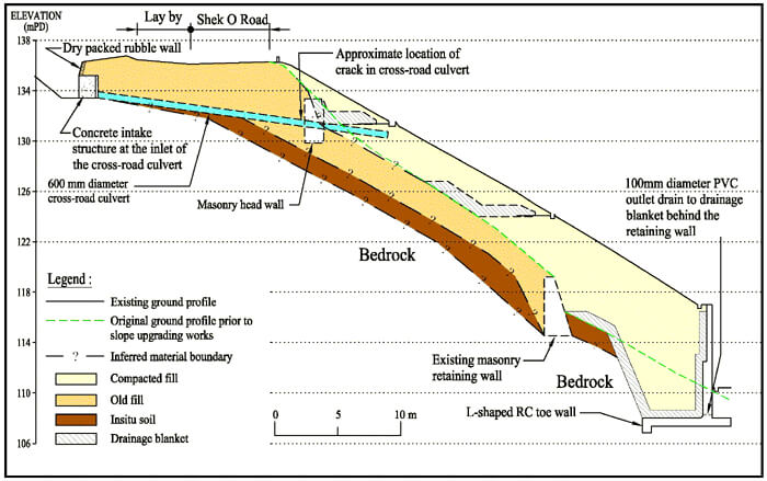
The November 2003 Slope Distress Below Shek O Road, Near Lan Nai Wan
Basic Data
Material:
Fill
Feature Affected:
Fill slope No. 15NE-B/FR31
Volume:
Not Applicable
Report Reference:
LSR 4/2005
Description
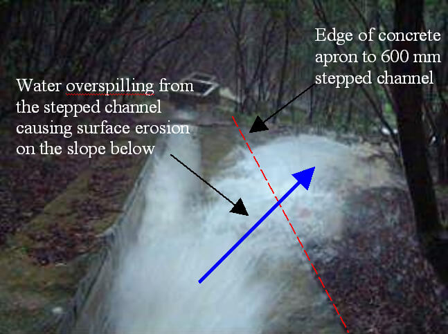
Notable signs of distress on an engineered fill slope below Shek O Road were observed in November 2003. The distress comprised erosion gullies (up to 1 m deep), ground movement, cracked drainage channels (up to 25 mm wide), about 100 mm shear displacement of a concrete step along a maintenance stairway, cracking of a cross-road culvert beneath the fill slope (15 mm to 40 mm wide circumferential crack) and formation of tension cracks. The exact timing of occurrence of the slope distress is unknown. No casualties or disruption to traffic were reported as a result of the incident.
Prior to the slope upgrading works in 1990's, the original fill slope was probably formed by tipping of fill across an existing drainage line that drained a large catchment area. The upgrading works in 1990's comprised the construction of an L-shaped retaining wall below the toe of the existing loose fill slope and placement of additional 3 m (max.) thick compacted fill cap over the existing loose fill. As part of the slope upgrading works, an existing 600 mm diameter cross-road culvert was extended by about 6 m and connected to the newly constructed slope surface drainage system.
The slope distress was probably related to subsurface ground movement due to long-term settlement and water ingress into the old fill stratum. The erosion gullies below the outlet of the cross-road culvert were probably caused by concentrated surface runoff overspilling from the stepped channel immediately downstream of the culvert.
Observations
This incident serves to highlight the potential damage due to post-construction movement associated with the placement of compacted fill over existing loose fill. It also shows the importance of need for attention to detail in design and construction of slope drainage provisions.
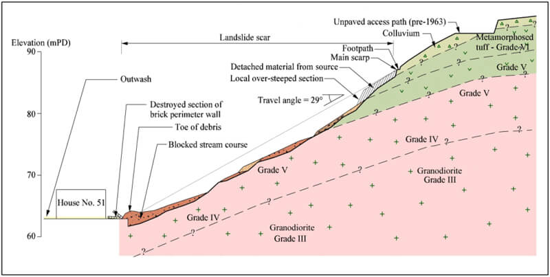
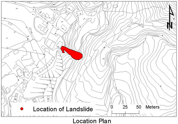
The 5 May 2003 Landslide on the Natural Hillside Behind House No. 51, Wong Chuk Yuen Village, Yuen Long
Basic Data
Material:
Colluvium/Completely Decomposed Tuff
Feature Affected:
Natural Hillside
Volume:
160 m3
Report Reference:
Review of the 5 May 2003 Landslide on the Natural Hillside behind House No. 51, Wong Chuk Yuen Village, Yuen Long
Description
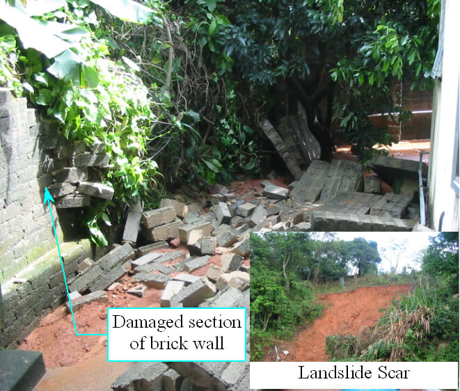
A major landslide (about 160 m3) occurred on the hillside above house No. 51, Wong Chuk Yuen, during heavy rainfall (with return period about 50 years). The landslide debris entered an existing depression immediately below the source area and became a debris flow. The debris blocked the stream course at the toe of the hillside and partly damaged a brick fence wall at the back of house No. 51. Debris outwash entered a village house and three occupants were evacuated from the house shortly after the landslide. The house was closed temporarily for about five months following the landslide incident. No casualties were reported.
The source area of the landslide was locally over steepened (about 60°), which was probably due to the presence of an existing scarp formed by erosion or previous instability within the deeply weathered granodiorite.
The natural hillside has a history of retrogressive failures. The May 2003 failure was probably caused by the development of transient water pressures within the surface mantle of colluvium, which was locally over-steepened probably due to the presence of an existing scarp formed by erosion or previous instability within the deeply weathered granodiorite.
There are no records of landslides in the vicinity of the 5 May 2003 landslide site in both the NTLI and GEO's large landslide database. However, there is a history of retrogressive instability along the existing steep-sided gully above the house No. 51 over the past 50 years. The instabilities were probably the result of adverse geological conditions which include the presence of a local area of highly kaolinised, extremely weak, completely decomposed altered granodiorite in the lower hillside area, together with stream undercutting action. Human influence, which includes illegal cutting, construction of an unpaved access path and drainage ditch across the hillside, may have been other contributory factors to the past failures.
Observations
This incident serves to highlight the potential natural terrain landslide hazards from catchments with a history of failures, that apparently has no record of any past instability according to the NTLI.