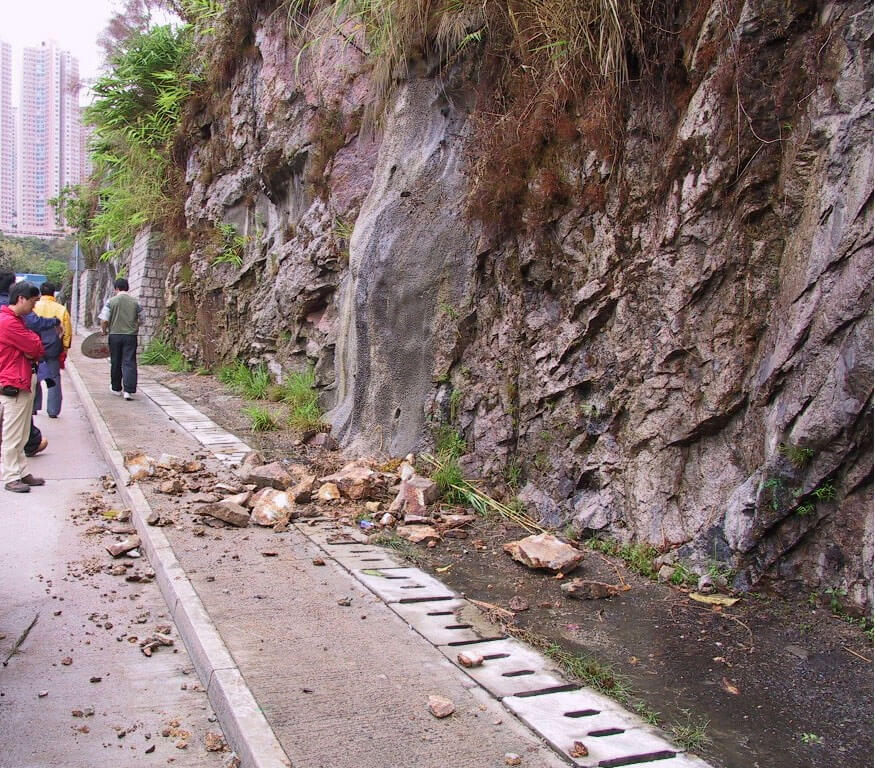
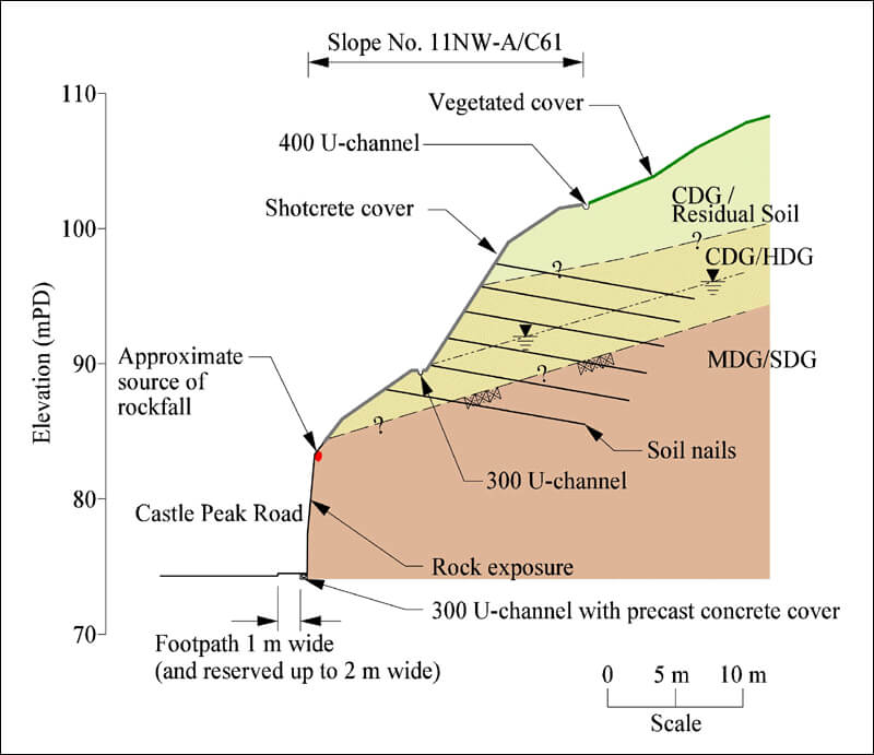
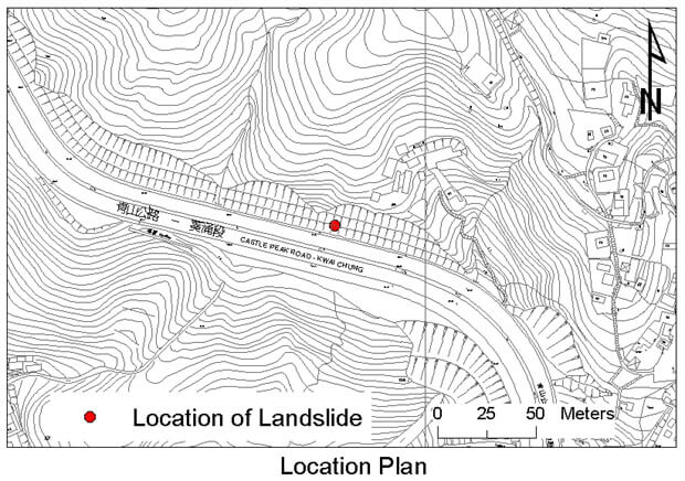
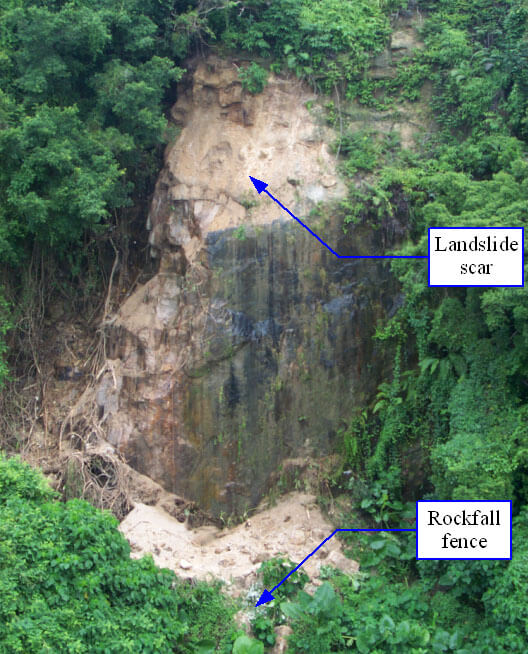
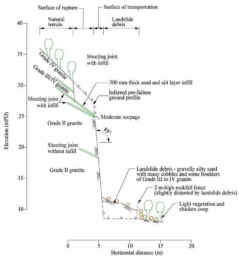
The 23 March 2002 Rockfall Incident at Slope No. 11NW-A/C61 at Castle Peak Road, Kwai Chung
Basic Data
Material:
Decomposed Granite
Feature Affected:
Slope No. 11NW-A/C61
Volume:
0.1 m3 (Rockfall)
Report Reference:
GEO Report No. 157
Description
The rockfall (0.1 m3) occurred on an exposed rock cut portion of a soil/rock cut slope above Castle Peak Road. Most of the debris fell onto the footpath at the toe of the slope and the remainder fell onto the road causing temporary closure of one lane of the road. No casualties were reported. The consequence could have been very serious given the heavy traffic on the road.
The detachment of the rock blocks, which occurred shortly after a period of unexceptional rainfall, was probably triggered by the development of cleft water pressure in the sub-vertical joints behind the rock blocks as a result of opening of the rock joints due to progressive deterioration. The progressive deterioration of the rock face was possibly exacerbated by the root action of unplanned vegetation, which quickly spreaded across the slope following the completion of slope upgrading works in 2002.
Extensive slope upgrading works were carried out on the cut slope. Rock slope stabilisation works, including, rock dowels, rock bolts, buttresses, dentition, scaling of loose rocks, shotcreting of local areas and rakings drains were implemented at the recommendations of an experienced geotechnical engineer following detailed mapping. No stabilisation works were considered necessary in the immediate vicinity of the source area of the rockfall.
There were no surface drainage provisions at the interface of the newly applied shotcrete covered soil cut portion and the exposed rock cut portion below. Concentrated surface runoff was probably directed onto the exposed rock cut portion, thus promoting the progressive deterioration and rapid growth of unplanned vegetation.
Observations
The incident highlights the potential hazard of inadequate drainage details at the interface of a soil/rock cut slope and the necessity of more robust measures (such as rock mesh netting) to combat small scale local failure of rock cut slope.
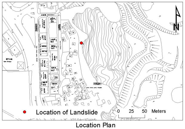
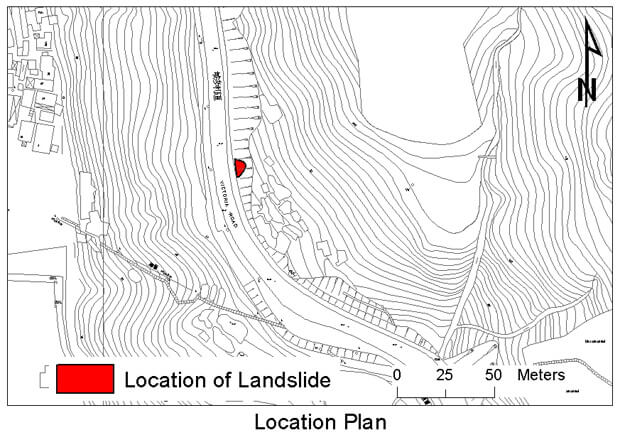
The 16 September 2002 Landslide at Slope No. 11NE-D/C18 at Cha Kwo Ling Tsuen, Fan Wa Street, Lam Tin
Basic Data
Material:
Highly / Moderately Decomposed Granite
Feature Affected:
Cut slope No. 11NE-D/C18
Volume:
30 m3
Report Reference:
GEO Report No. 160
Description
he landslide occurred on a 30 m high 220 m long soil/rock cut slope (which is a disused quarry face) behind a squatter area. The source area of the landslide was about 20 m high and the landslide debris was retained by a 2 m high rockfall fence at the slope toe. As a result of the impact of the landslide debris, a 20 m section of the rockfall fence was distorted. No casualties were reported.
The landslide was probably triggered by infiltration and the build-up of transient water pressure within the rock joints during the rainfall preceding the failure. Adversely orientated sheeting joints and sub vertical joint sets, which allow the forming of basal, side and back release surfaces, were identified on the slope. The oversteep soil/rock cut slope with weak rock mass was also a factor contributed to the failure.
The cut slope has a history of landslides, is adjacent to a large number of squatter dwellings. As part of the Squatter Area Improvement Programme in the mid-1980s, a 140 m long, 2 m to 5 m high rockfall fence was prescribed by Housing Department's geotechnical consultants (without detailed design assessment) and constructed at the slope toe.
The rockfall fence along parts of the slope toe retained the debris associated with small-scale landslide in 1989 (5 m3), 1990 (10 m3) and 1995 (< 1 m3). In August 1995, a major landslide (1,000 m3) occurred which destroyed a 60 m length of the rockfall fence.
Observations
This incident highlights the potential hazard of a steep soil/rock cut slope with adversely dipping sheeting joints and some sub-vertical joints which allow the forming of release surfaces, together with persistent seepage along these joints.
The 9 February 2002 Rockfall on Slope No. 11SE-C/CR29 at Hong Kong Stadium, So Kon Po
Basic Data
Material:
Moderately to Slightly Decomposed Granite
Feature Affected:
Cut slope No. 11SE-C/CR29
Volume:
0.5 m3 (Rockfall)
Report Reference:
Review of the 9 February 2002 Rockfall on Slope No. 11SE-C/CR29 at Hong Kong Stadium
Description
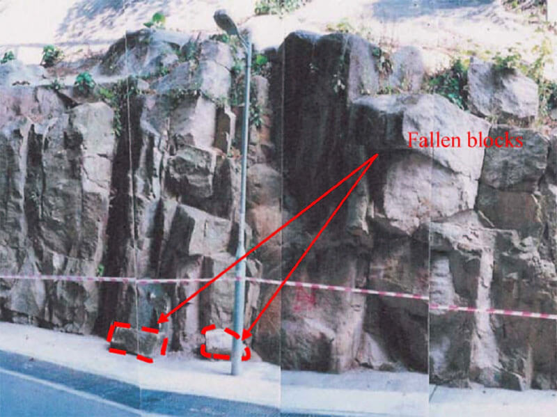
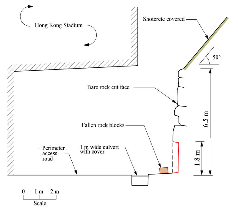
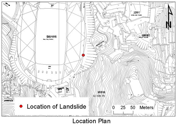
The rockfall incident involved the detachment of a sizeable rockfall during dry season from the toe portion of an engineered soil/rock cut slope behind the Hong Kong Stadium. There was no rainfall on the day of the failure and only 4 mm over the 10 days preceding the failure. The detached rock blocks fell on the edge of the stadium perimeter road. No casualties were reported.
The detachment of the rock blocks may have been a result of progressive local deterioration or degradation of the rock slope.
Scaling and removal of loose rock blocks were recommended by the EI consultant in October 1999 as "emergency measures" covering the location of the 2002 rockfall. Specific locations of loose blocks to be removed were not given in the EI's recommendations. Rock scaling works were carried out in June 2000. The EI consultant did not undertake follow-up inspection after the slope maintenance works.
Observations
The incident highlights the importance of providing sufficient details of the required slope maintenance works by the EI consultant, in particular for rock scaling works which the input of engineering geologist during, and after the completion of preventive works are essential.
The 15 September 2002 Landslide at Slope No. 7SE-C/CR323 at Ngau Pei Sha New Village, Sha Tin
Basic Data
Material:
Completely Decomposed Granite
Feature Affected:
Cut slope No. 7SE-C/CR323
Volume:
50 m3
Report Reference:
GEO Report No. 163
Description
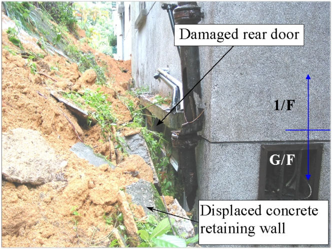
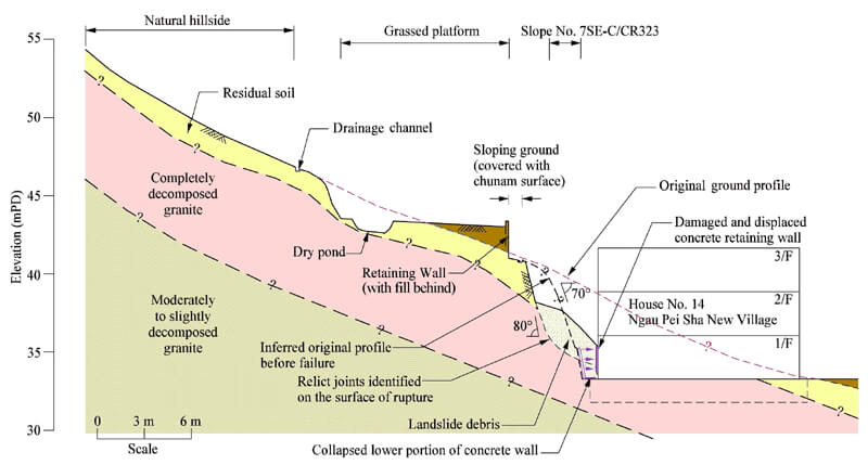
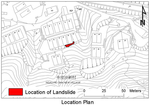
The landslide incident involved the major failure of a 4.5 m high 70° soil cut slope and a 2 m high concrete toe wall in front of a row of 3-storey village houses in Ngau Pei Sha New Village, Sha Tin. The landslide debris piled up against the backs of two houses as high as the first floor level. As a result, six houses were temporarily evacuated and a total of 15 residents were affected. No casualties were reported.
The landslide occurred following a period of moderate rainfall (with a maximum return period of about 3 years). The failure was probably triggered by the ingress of surface runoff through the cracked slope surface cover and grass covered platform above the slope resulting in a reduction of soil suction and shear strength.
Based on detailed post-landslide examination, extensive slickensided, undulating, adversely orientated kaolin-infilled relict joints within the CDG were found close to the rupture surface, together with some minor opening of the relict joints. This provided evidence of past movement and progressive deterioration of the slope.
According to slope maintenance records, cracks on the hard slope surface cover rapidly recurred three months after the maintenance works in April 2001. This may also serve as a possible indicator of the presence of a significant adverse geological feature which contributed to the major failure.
Observations
This incident serves to highlight the importance of paying due attention to extensive and rapid recurrence of cracking on hard surface cover of slope which may indicate the presence of significant adverse geological features and progressive deterioration of slope that may affect its stability.
The 22 May 2002 Rockfall on Slope No. 11NE-A/C284 at Shatin Pass Road, Tse Wan Shan
Basic Data
Material:
Moderately decomposed Granite
Feature Affected:
Cut slope No. 11NE-A/C284
Volume:
7 m3 (Rockfall)
Report Reference:
GEO Report No. 156
Description
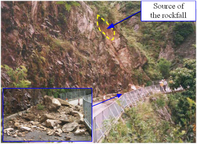
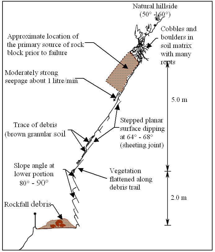
The rockfall comprised the detachment of sizeable rock blocks (7 m3 in volume) during moderate rainfall from a height of about 7 m on an old rock cut slope above Shatin Pass Road, Tse Wan Shan. The rockfall debris was deposited onto Shatin Pass Road resulting in complete blockage of the road. No casualties were reported.
The rockfall involved a planar sliding failure along an adversely orientated, steeply dipping (about 64° to 68°) basal release surface with a lateral persistent of about 10 m, which is probably a sheeting joint. The rockfall was probably caused by the transient build-up of cleft water pressure behind rock blocks. Signs of gradual opening up of rock joints were identified which suggest that progressive deterioration may have played an important role in the rockfall. Also, root action associated with unplanned vegetation was a contributory factor to the rockfall.
The opened rock joints were noted previously by the SIRST and EI consultants in 1996 and 2001 respectively. The EI recommended slope maintenance works in 2001 comprising provision of wire mesh netting and sealing up of open joints. No specific works were recommended for the sizeable rock blocks that subsequently failed in 2002. Also, the recommended maintenance works were yet to be carried out before the May 2002 rockfall incident.
Observations
The incident serves to highlight the potential hazard of old rock cut slopes, which are particularly vulnerable to gradual deterioration and potential instabilities caused by root action associated with unplanned vegetation. It is important to carry out the necessary maintenance works to deal with unplanned vegetation on old cut slopes and to prevent deterioration of slope conditions.
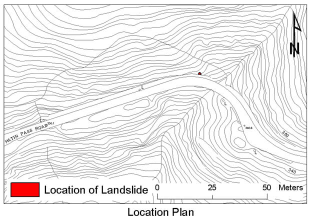
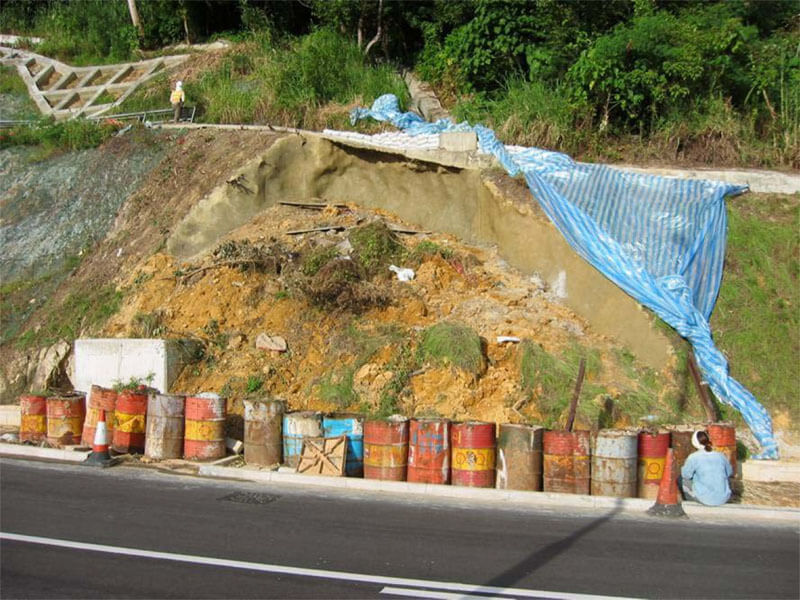
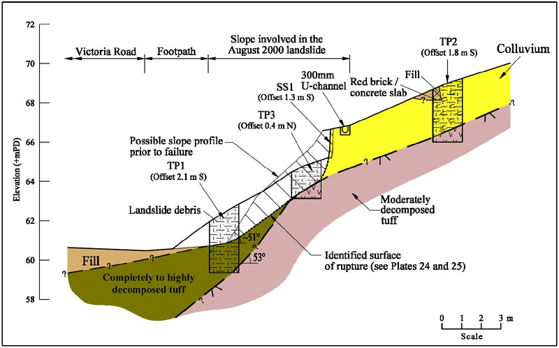
The 10 August 2002 Landslide on a Cut Slope at Victoria Road, Pokfulam
Basic Data
Material:
Colluvium
Feature Affected:
Soil cut slope under construction
Volume:
80 m3
Report Reference:
GEO Report No. 158
Description
The major landslide occurred on a 12 m long, 50° unsupported soil cut portion of a 180 m long newly formed soil/rock cut slope within an active construction site of a road improvement project at Victoria Road, Pokfulam. The landslide debris was deposited within an area in front of the slope toe within the site and did not affect the traffic of Victoria Road. No casualties or road closure were reported.
The landslide involved the failure of a surface mantle colluvium overlaying moderately decomposed tuff, which probably caused by the build-up of transient groundwater pressure within the colluvium. The failed slope portion was close to an existing natural drainage line where there may be concentrated surface and subsurface water flow. Post-failure inspections revealed that inadequate maintenance of the partially completed surface drainage system during the construction stage was a contributory factor to the failure.
At the failed section, the cut slope was found by the resident site staff during construction stage to be oversteep and the contractor was requested to rectify the situation as soon as possible. However, follow-up action was not yet taken by the contractor up to the time of failure. Also, no specific measures were provided at the toe of the oversteep cut portion to protect the traffic lanes of Victoria Road.
Observations
The incident serves to highlight the importance of providing adequate qualified geotechnical supervision input and the need of tightening up action on potential landslide hazards identified during construction stage. Also, it is important to provide a proper maintenance to completed/partially completed slope drainage system within an active construction site.
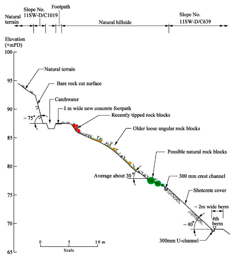
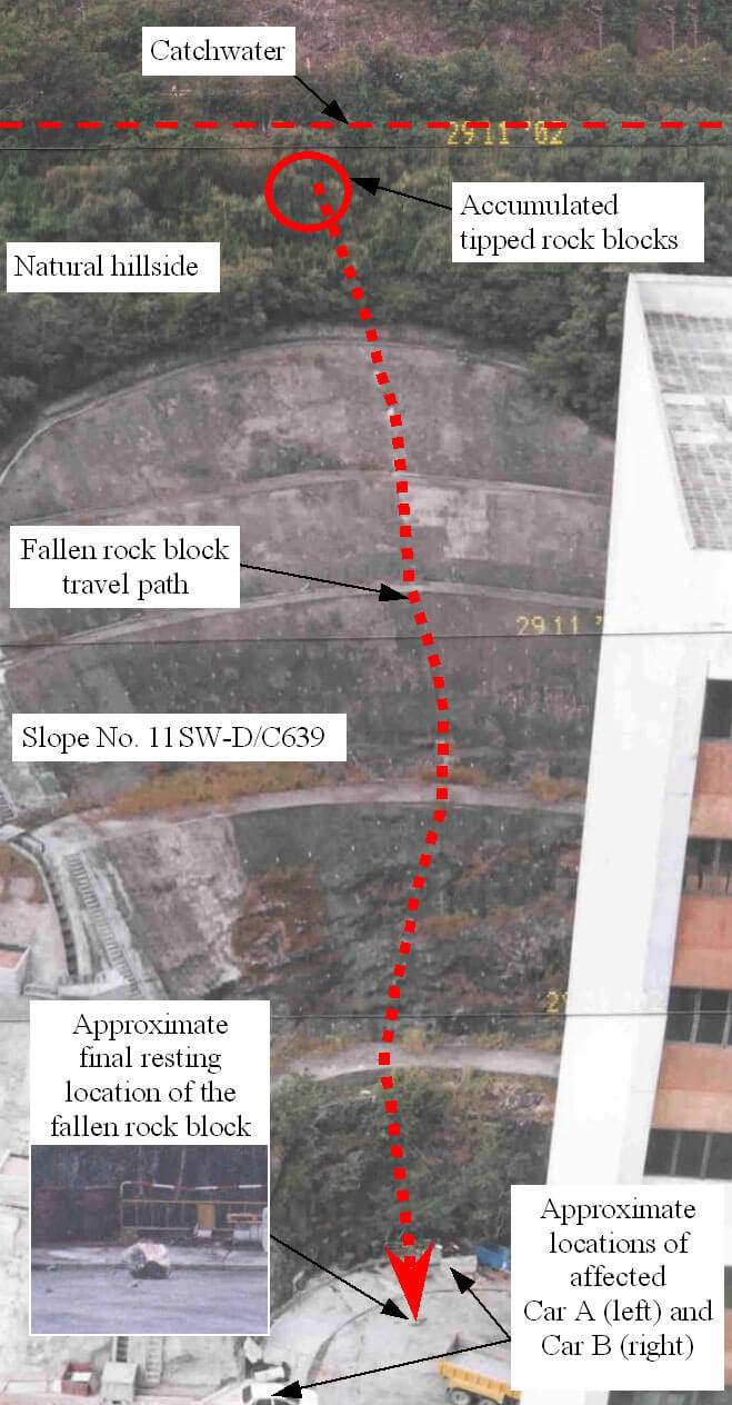
The 28 November 2002 Rockfall from Hillside above Yip Hing Street, Wong Chuk Hang
Basic Data
Material:
Moderately Decomposed Tuff
Feature Affected:
Natural Hillside
Volume:
0.2 m3 (Rockfall)
Report Reference:
GEO Report No. 164
Description
The incident involved the detachment of an isolated rock block form the hillside below a catchwater access path and above cut slope No. 11SW-D/C369 during relative dry weather. The detached rock block travelled down the hillside and cut slope and impacted the ground on Yip Hing Street at the slope toe with an elevation different of 50 m. The impact generated several small fragments of flyrocks. As a result, two vehicles that were parked at Yip Hing Street were slightly damaged by the flyrocks and the driver in one of the vehicles was slightly injured by shattered glass of the vehicle.
Detailed site mapping suggests that the source of the fallen rock block was not a naturally-occurring boulder. The fallen rock block was probably deposited on the hillside below the catchwater access path by human action. The subject hillside was found to be littered with abundant rock blocks that were probably deposited at different times. As revealed by API, some of these rock blocks were probably tipped several tens of years ago but some of the rock blocks were found to be recently tipped.
The possible trigger mechanisms or contributory factors in respect of the rockfall were found to include human disturbance or gradual destabilisation due to progressive deterioration of any toe support afforded to the subject rock block.
Observations
The incident highlights the potential hazard of uncontrolled littering/dumping of material on natural hillside, which could lead to serious consequences at a significant distance downslope.