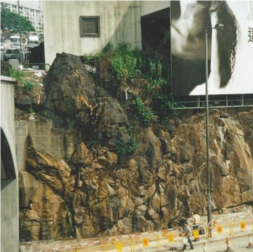
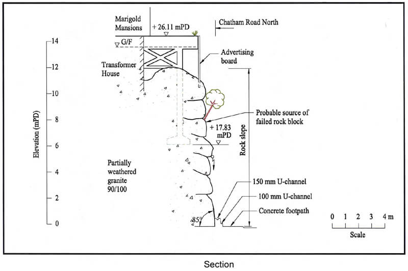
The 18 June 1999 Rockfall at Chatham Road North
Basic Data
Material:
Partially Weathered Granite
Feature Affected:
Cut Slope No. 11NW-D/C81
Volume:
A single rock block (0.3 m x 0.3 m x 0.5 m) involved
Report Reference:
Initial Review of the 18 June 1999 Rockfall from Slope No. 11NW-D/C81 at Chatham Road North
Description
The rockfall occurred on a 12 m high rock cut slope which was previously assessed by the GEO in a Stage 1 Study in 1990 as requiring "minor maintenance works". One lane of Chatham Road North was temporarily closed off as a result of the incident. There were no casualties reported.
The rockfall was predominantly the result of slope deterioration involving root action associated with an unplanned tree, together with inadequate slope maintenance. The presence of adversely orientated rock joints was also a contributory factor in the failure.
Upgrading works were carried out in 1997 over the southwestern portion of the registered rock cut slope (outside the failed portion), which was also covered by the 1990 Stage 1 Study.
Observations
The incident highlights the hazard of destabilising effects of unplanned vegetation and the adverse effect of inadequate maintenance of a rock slope.

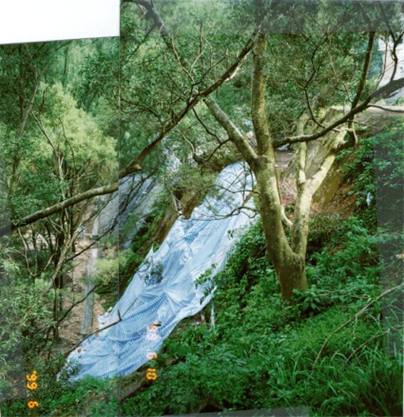
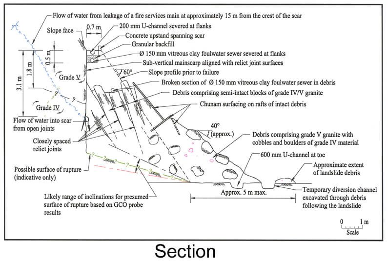
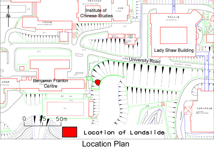
The 7 June 1999 Landslide at Chinese University of Hong Kong
Basic Data
Material:
Colluvium / Decomposed Volcanic Rocks
Feature Affected:
Cut Slope No. 7NE-C/C23
Volume:
30 m3
Report Reference:
GEO Report No. 123
Description
The landslide occurred on a 15 m high cut slope which was previously assessed as being up to the required standards in 1988. No casualties were reported as a result of the incident.
The landslide was primarily triggered by the leakage from a fire services watermain at the crest of the slope. The geometry of the failure (probably incorporating a low-angle basal rupture surface) suggests that it was partly controlled by adversely-orientated relict joints with weak infill which were not identified and considered in the previous assessment.
The presence of extensive unplanned vegetation on the chunamed portion (where the weathering conditions are more advanced) of the slope surface indicates that lack of slope maintenance may have been a contributory factor to the failure. The presence of open, root-filled joints and signs of local slope movement suggest that the slope may have undergone progressive deterioration for some considerable time (i.e. several years) prior to the failure in 1999.
Observations
The incident highlights the fact that leakage of water-carrying service may cause a landslide. It also illustrates the need in slope stability assessment to consider the presence of relict joints, particularly those with weak infill, in the geological model.
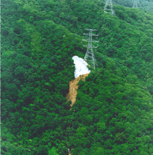
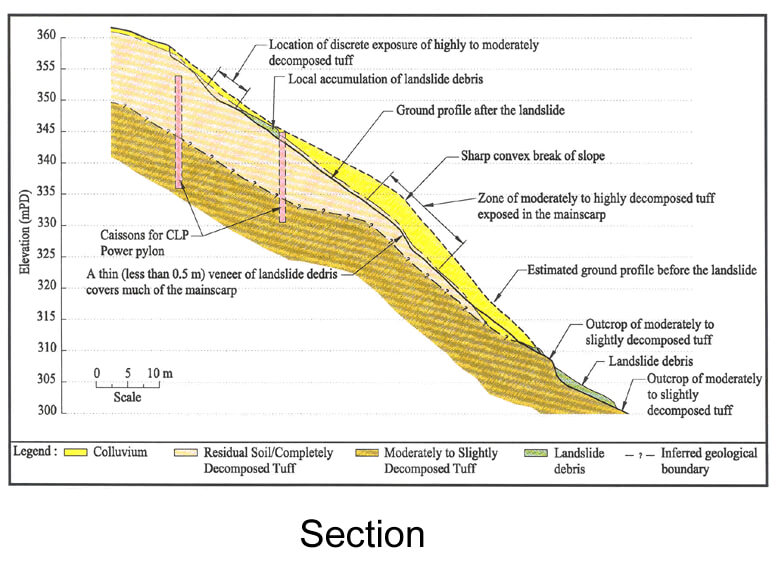
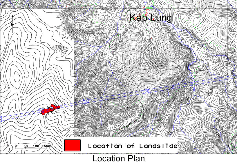
The August 1999 Landslide above Kap Lung, Shek Kong
Basic Data
Material:
Colluvium / Decomposed Volcanic Rocks
Feature Affected:
Natural Hillside
Volume:
2,000 m3
Report Reference:
GEO Report No. 121
Description
This landslide occurred on a natural hillside largely within a compound of CLP Power situated in a remote area and was triggered by severe rainfall with an estimated maximum return period of about 85 years. No casualties were reported as a result of the incident. Extensive vegetation clearance was carried out within the compound (1,400 m2) during construction of the pylon in 1995. The vegetation remained sparse at the time of failure.
The landslide was in the form of a channelised debris flow and occurred on a hillside that was previously assessed and checked to the required standards, as part of the foundation design for the electricity pylon. However, the past slope stability assessment did not consider the sharp convex break of slope and the area with a steeper ground profile, which probably corresponds to previous instability. Also, the presence of a surface mantle of colluvium was not identified in the previous ground investigation.
The relatively low travel angle of the landslide debris (15°) indicates that the wet channelised debris flow was mobile, possibly involving a large volume of surface water running down the stream course.
Observations
This landslide highlights the potential for reactivation of past failures on the natural hillside (as reflected by the sharp convex break in slope) due to influence of human action (viz. increased infiltration due to de-vegetation).
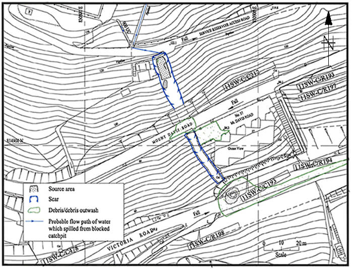
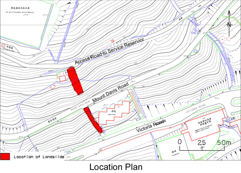
The 24 August 1999 Landslide above No. 37 Mount Davis Road
Basic Data
Material:
Decomposed Volcanic Rocks
Feature Affected:
Natural Hillside above Cut Slope No. 11SW-C/C212
Volume:
200 m3
Report Reference:
Initial Review of the Landslide above No. 37 Mount Davis Road on 24 August 1999
Description
The failure was a "near-miss" incident in that the debris narrowly missed an apartment block below Mount Davis Road. The incident involved the fracturing of a 150 mm diameter fresh water pipe and undermining of a 1.4 m diameter fresh water main located at the crown of the landslide scar. The latter is an important trunk main of the Mount Davis Service Reservoir, supplying potable water to the Hong Kong South area.
The rainfall that triggered the landslide was not severe (estimated maximum return period of about 4 years). The surface runoff from a significant catchment above the landslide site was diverted due to blockage of the catchpit inlets at the toe of the hillside above the WSD access road. Surface water flowed along the access road above the crest and over spilled near a bend, resulting in concentrated water flow and water ingress into the slope leading to the failure.
Inadequate provision and maintenance of the surface water drainage provisions above the access road and the lack of surface drainage or an upstand on the downhill side of the access road were probably key contributory factors in causing the failure.
Observations
The incident highlights the importance of proper road drainage provisions and detailing to cope with uncontrolled discharge of surface water arising from blocked catchpits, especially where there is a substantial catchment uphill. It also serves as a reminder that overspilling of surface water onto a hillside downslope of access roads may result in a major failure which could affect developments further downhill.
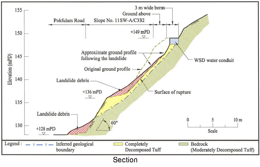
The 24 August 1999 Landslide at Pokfulam Road Opposite the Chinese Christian Cemetery
Basic Data
Material:
Decomposed Volcanic Rocks
Feature Affected:
Cut Slope No. 11SW-A/C332
Volume:
100 m3
Report Reference:
Initial Review of the 24 August 1999 Landslide at Pokfulam Road, Opposite the Chinese Christian Cemetery
Description
The landslide occurred at the upper portion of a 25 m high cut slope. As a result of the incident, one lane of Pokfulam Road was temporarily closed. No casualties were reported.
The rainfall that triggered the landslide (estimated maximum return period of about 6 years) was not the most severe rainfall experienced at the site in the preceding 21 years. At the time of failure, water conduit reconstruction works were in progress near the crest of the landslide.
Key contributory factors to the landslide were probably inadequate consideration of the management of surface water flow due to changes in the site setting associated with the construction works, together with lack of slope maintenance.
The subject slope was in a poor state of maintenance.
Observations
The incident illustrates the importance of giving due regard to surface water drainage both during construction and in the long term. It further highlights the hazard of carrying out temporary excavations at the crest of slopes, particularly in the wet season.
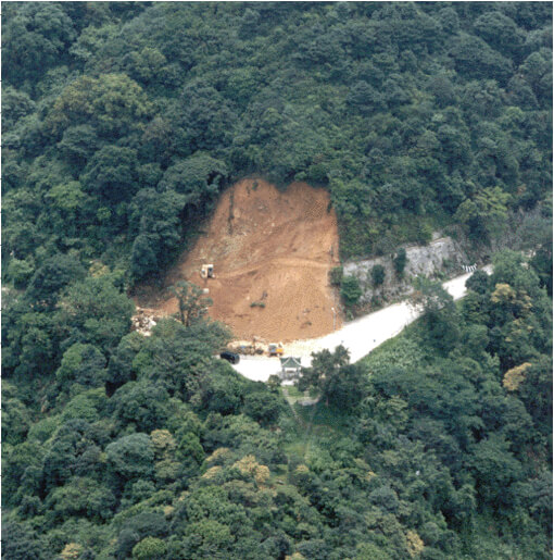
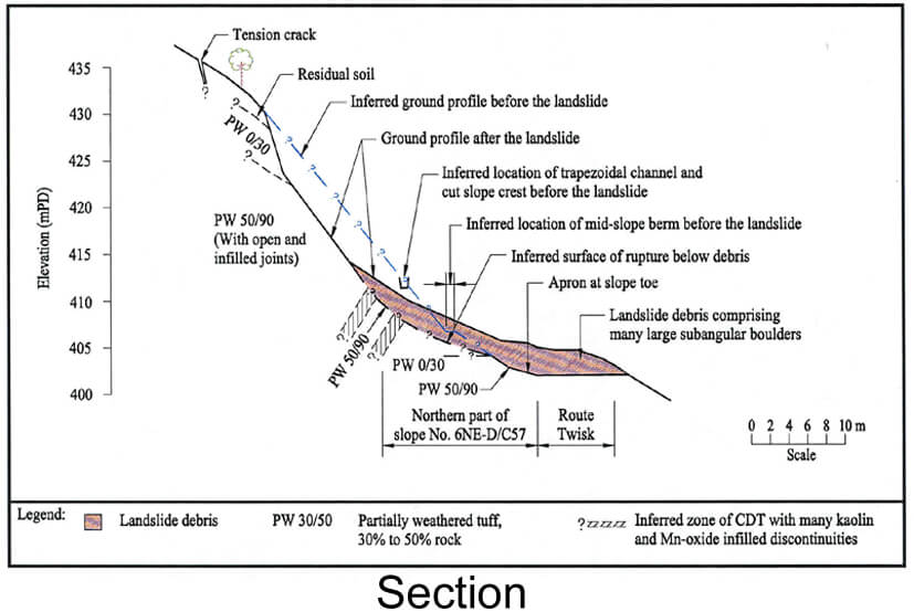
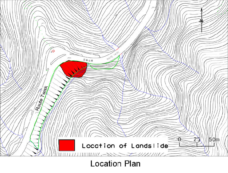
The 23 August 1999 Landslide at Route Twisk Opposite Lookout Point Near Shek Kong
Basic Data
Material:
Decomposed Volcanic Rocks
Feature Affected:
Cut Slope No. 6NE-D/C57
Volume:
1,000 m3
Report Reference:
GEO Report No. 120
Description
The landslide affected a 25 m high, old cut slope, as well as a portion of the hillside above. The site had a history of instability both before and after cut slope formation which was undertaken between 1949 and 1963. The landslide debris completely blocked Route Twisk. No casualties were reported as a result of the incident. A second failure occurred near the crest of the scar during urgent repair works, five days after the initial landslide. Two labourers working on the slope suffered minor injuries as a result of the second failure.
The rainstorm that triggered the failure was not the most severe storm experienced at the landslide site in the preceding 16 years since the nearest automatic raingauge was installed. Progressive deterioration of the slope condition, as evidenced by the presence of major pre-existing tension cracks and distressed surface drainage, exacerbated by lack of maintenance, was a contributory factor to the major failure. The failure had a strong element of structural control due to the presence of adverse relict discontinuities.
Observations
The incident emphasises the importance of thorough inspection of the registered slope and the area immediately above its crest during Engineer Inspections to check for possible existence of distress and tension cracking.
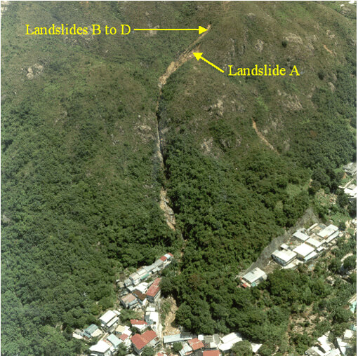
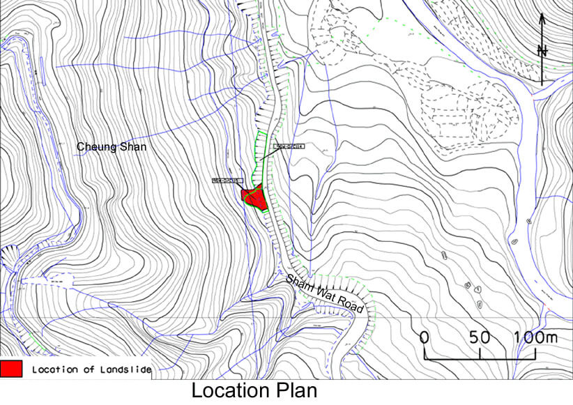
The 23 August 1999 Debris Flow at Sham Tseng San Tsuen
Basic Data
Material:
Colluvium / Decomposed Granite
Feature Affected:
Natural Hillside
Volume:
600 m3
Report Reference:
Report on the Debris Flow at Sham Tseng San Tsuen of 23 August 1999
Description
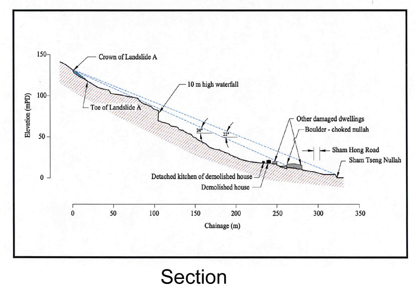
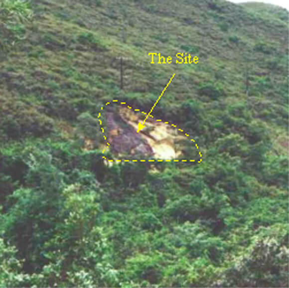
Four landslides (A to D) occurred on the natural hillside above Sham Tseng San Tsuen, giving rise to a channelised debris flow down a stream course, which demolished a house and its detached kitchen structure, and severely damaged several other dwellings within the squatter village. One fatality and thirteen injuries were reported.
The debris flow occurred during a severe rainstorm with an estimated maximum return period of about 49 years. Landslide A (600 m3) was the primary source of the debris flow. The landslides were probably caused by the build-up of elevated water pressures within the surface colluvium following the severe rainfall.
The hillside is vulnerable to rain-induced shallow failures. The thin mantle of bouldery colluvium overlying relatively less permeable material is favourable to the build-up of perched water tables during heavy rain. The presence of relict failures would probably have disturbed and weakened the rock mass and adversely affected the local hydrogeology by promoting direct infiltration of rainwater through the open or partially infilled joints. A hillfire about 4 to 5 years before the failure had also removed much of the vegetation cover. It was evident that the hillside had been subjected to progressive deterioration with discontinuities opening up with time, which were probably associated with past intermittent slope movements.
The subject hillside suffered extensive failures (> 10 notable failures) during the severe rainstorms in 1982. It is noteworthy that the 1999 rainstorm resulted in seven notable landslides, six of which were at different locations compared to the failures in 1982.
Observations
The incident highlights the practical significance of different rainstorms resulting in landslides at different locations on a vulnerable hillside and the difficulty of predicting exact locations of failures on natural hillside. Care is needed in the interpretation of the historical failure records because of :
(a) variations in rainfall characteristics between storms leading to differing responses at different parts of the hillside,
(b) progressive deterioration of the hillside which can vary at different locations depending on the local setting (hence the susceptibility of different areas to failure may change with time), and
(c) the possibility that the most vulnerable areas of the hillside may have detached, rendering these same areas less vulnerable to future rainstorms.
The incident also highlights the fact that a sufficiently extensive area (i.e. not only confined to the catchment affecting the site under consideration) should be considered for natural hillside assessments in order to obtain more representative information on the vulnerability of the hillside.
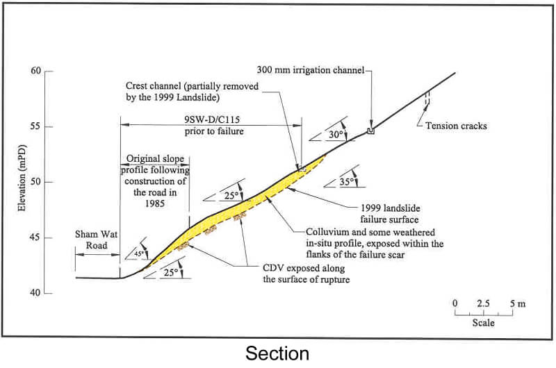
The 24 August 1999 Landslide at Sham Wat Road, Lantau Island
Basic Data
Material:
Decomposed Volcanic Rocks
Feature Affected:
Cut Slopes Nos. 9SW-D/C114 and 9SW-D/C115 and the Ground abovee
Volume:
1,700 m3
Report Reference:
GEO Report No. 122
Description
The landslide occurred in two soil cut slopes formed in 1985, resulting in temporary closure of the single-lane Sham Wat Road. No casualties were reported as a result of the incident.
The failure was probably triggered by rainfall with an estimated maximum return period of about 9 years. The cut slope and the ground above were probably affected by progressive deterioration, including the formation of open tension cracks, which led to an increase in infiltration of surface water into the near-surface materials. This, combined with the adverse hydrogeological setting of the site, i.e. colluvial mantle with erosion pipes overlying saprolites, were significant contributory factors to the landslide.
The hillside has a history of failure and an adverse setting (e.g. geomorphological evidence of large-scale relict instability, presence of colluvial debris fan/lobes, concentrated surface water runoff and subsurface seepage associated with the ephemeral drainage lines). The presence of laterally extensive tension cracks was probably caused or exacerbated by the formation of the road cutting at the toe of the hillside in 1985.
Observations
The incident serves as a reminder that geotechnical consideration in route planning and a proper engineering geological assessment are important for a new road cutting, particularly when the cutting is made in terrain with a history of failure.
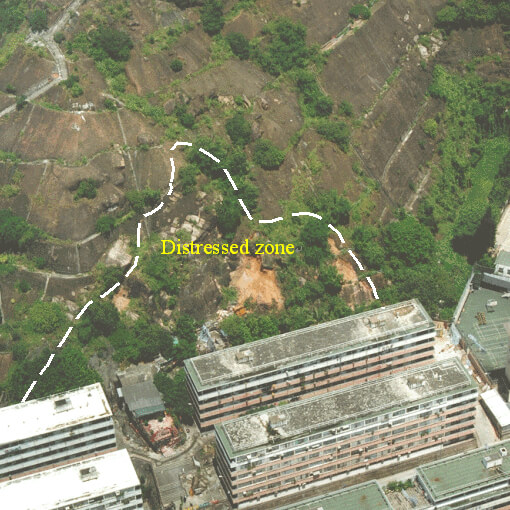
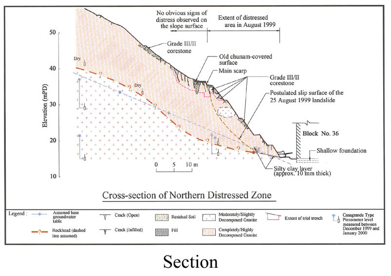
The 25 August 1999 Landslide at Shek Kip Mei Estate
Basic Data
Material:
Decomposed Granite
Feature Affected:
Cut Slope No. 11NW-B/C90
Volume:
6,000 m3
Report Reference:
Shek Kip Mei Landslide of 25 August 1999
Description
Significant signs of distress were noted at a 50 m high old cut slope to the rear of blocks Nos. 36 and 38 of Shek Kip Mei Estate. No casualties were reported as a result of the incident. Three housing blocks were permanently evacuated.
The distress was probably caused by the build-up of adverse transient water pressures following prolonged, severe rainfall (estimated maximum return period of 31 years) which was probably amongst the worst rainstorms experienced by the cut slope since its formation in the 1950's.
The slope was reviewed as part of area geotechnical studies in the late 1970's and the recommended slope works were subsequently carried out.
The slope is situated partly within an area of a large relict landslide, and formerly deep erosion. The presence of persistent adversely orientated discontinuities with weak infill, whose degree of lateral continuity (> 60 m) is not commonly observed in Hong Kong, was one of the unfavourable factors contributing to the failure. The presence of extensive tension cracks and old drainage lines meant that the slope was vulnerable to loss of soil shear strength arising from enhanced infiltration of surface runoff via local defects in the hard slope surface cover.
The slope surface cover was in an ageing state with widespread local cracking, unplanned vegetation growth and voids beneath the cover. Surface infiltration through the unauthorized cultivation area above the slope could also have contributed to the failure by allowing water ingress into the slope.
Observations
The incident highlights problems with old slopes assessed in the early years of setting up the slope safety system in Hong Kong. These form a target group deserving attention, particularly where slopes were assessed to rely on suction to maintain stability. The incident also emphasises the importance of maintaining the quality of Engineer Inspections and ensuring regular maintenance of slopes to prevent deterioration.
The incident also highlights the need to examine effective means to discourage unauthorised cultivation and to take timely action upon discovery of unauthorised cultivation.

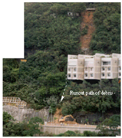
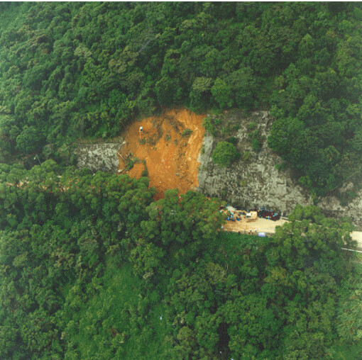
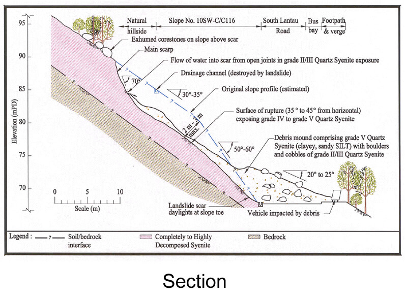
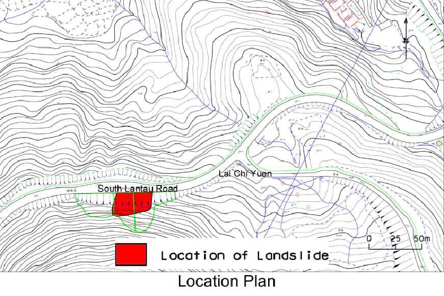
The 24 August 1999 Landslide above South Lantau Road near Lai Chi Yuen
Basic Data
Material:
Decomposed Syenite
Feature Affected:
Cut Slopes Nos. 10SW-C/C116 and 10SW-C/C1173
Volume:
1,000 m3
Report Reference:
GEO Report No. 120
Description
The landslide affected a 20 m high, old soil cut slope which had a history of instability. Debris from the landslide completely blocked South Lantau Road at the toe and a vehicle was damaged as a result of the incident, with the driver narrowly escaping injury.
The landslide was triggered by rainfall which was the most severe (estimated maximum return period of about 150 years) experienced at the site in the preceding 8 years. The blockage of crest surface drainage provisions aggravated the situation by increasing the amount of water available for infiltration. A combination of other factors which included an adverse hydrogeological setting and relict jointing, the presence of erosion pipes, possible tension cracks resulting from previous slope movement and the presence of localised subsurface voids (erosion features) in the uphill area, also promoted the amount of water ingress into the slope.
Observations
This landslide highlights the hazard of major instability of an old slope which has a history of relatively small failures and has been subjected to progressive deterioration associated with past slope movement.
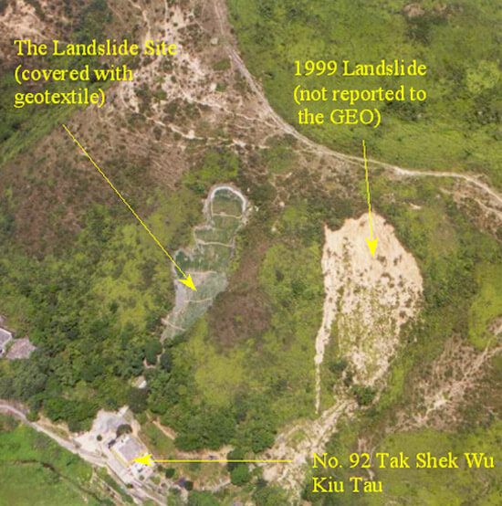
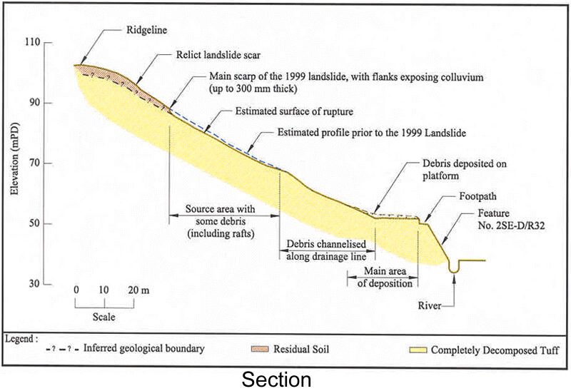
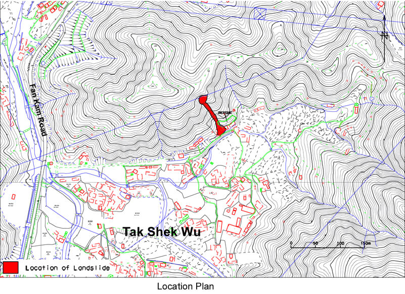
The 24 August 1999 Landslide above No. 92 Tak Shek Wu Kiu Tau near Pat Heung
Basic Data
Material:
Colluvium / Decomposed Volcanic Rocks
Feature Affected:
Natural Hillside
Volume:
260 m3
Report Reference:
Review of the 24 August 1999 Landslide on the Hillside above No. 92 Tak Shek Wu Kiu Tau near Pat Heung
Description
The landslide occurred on natural hillside above No. 92 Tak Shek Wu Kiu Tau near Pat Heung. The landslide debris became channelised and was deposited on a platform immediately adjacent to the residential building near the toe of the hillside. The travel angle was about 20° which indicates that the debris was relatively mobile. No casualties were reported as a result of the landslide.
The channelised debris flow was probably triggered by rainfall, with an estimated return period of about 25 years. The landslide occurred towards the top of an ephemeral drainage line, with its main scarp developed along a pre-existing tension crack (which was noted in the 1996 and 1998 aerial photographs). This was located below two relict landslide scars within one of several major ground depressions on the hillsides in this area.
The presence of rafts of relatively intact material within the source area, together with the exposures of planar surfaces on the surface of rupture, suggest that the initial instability involved shallow sliding failure (up to 1 m deep). In addition, the location of the landslide towards the top of the drainage line suggests that the failure may be part of the geomorphological development of the hillside. Other relict landslide scars have been identified within a number of depressions on the hillsides in the area and there is evidence of progressive deterioration of the hillsides.
Observations
This incident highlights the hazard of failure of natural terrain in close proximity to developments and the need to attend to vulnerable hillsides.
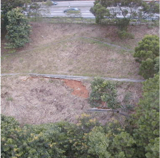
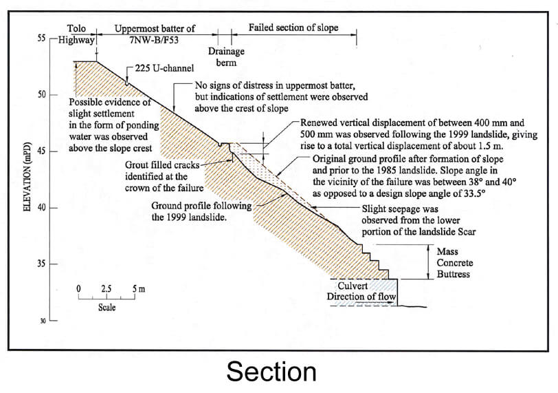
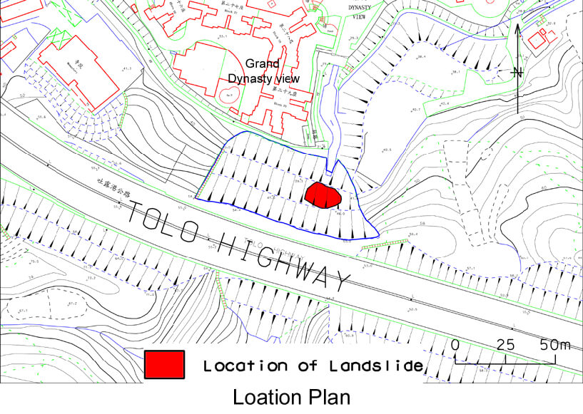
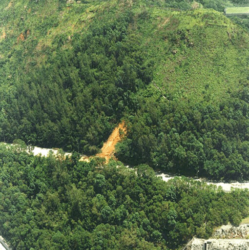
The 24 August 1999 Landslide below Tolo Highway, Garden Dynasty View, Tai Po
Basic Data
Material:
Fill
Feature Affected:
Fill Slope No. 7NW-B/F53
Volume:
240 m3
Report Reference:
Initial Review of the August 1999 Landslide below Tolo Highway, Garden Dynasty View, Tai Po
Description
The landslide involved the failure of a 22.5 m high embankment fill slope which was constructed in 1983. There were no casualties as a result of the landslide.
The landslide was triggered by severe rainfall (estimated maximum return period of about 40 years) which was the most severe event experienced at the site since the formation of the slope. The landslide occurred at a location that previously experienced significant settlement and failure (200 m3) in 1985. The failed area in 1985 was subsequently repaired using a combination of no-fines concrete, pressure grouting and a stepped concrete buttress at the slope toe.
It was also established in the post-1985 failure investigation that the drainage blanket beneath the fill embankment was excluded during construction in view of lack of seepage observed from the exposed ground mass.
Observations made after the 1999 failure identified the chunam in the adjoining section of slope, which was cracked and in a poor condition with localised areas of bulging, as being susceptible to infiltration of surface water. Sub-vertical grout seams identified in the main scarp of the landslide may have exacerbated the wetting-up of the near-surface material by creating a barrier to the percolation of seepage flows, thereby increasing the susceptibility of the slope to the formation of transient elevated groundwater pressure. The failure may also be associated with the localised presence of loose fill, as was established in the investigation following the 1985 failure.
Observations
This incident highlights the importance of ensuring proper fill compaction and attention to detailing of subsurface drainage provisions. The deletion of the subsurface drainage blanket beneath the fill embankment during construction was unfavourable to slope stability.
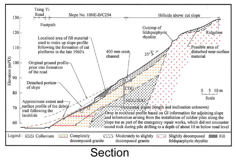
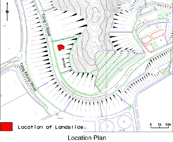
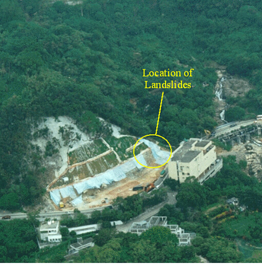
The 24 August 1999 Landslide at Tsing Yi Road, Tsing Yi Island
Basic Data
Material:
Colluvium
Feature Affected:
Cut Slope No. 10NE-B/C254
Volume:
1,000 m3
Report Reference:
GEO Report No. 122
Description
The landslide occurred on a 50 m high cut slope that was formed in the late 1970's and was designed and checked to the required standards. Landslide debris completely blocked the two-lane road at the toe of the slope and trapped a taxi and a lorry in the northbound carriageway. There were no casualties resulting from the landslide.
The failure was triggered by severe rainfall with an estimated maximum return period of about 50 years. The unfavourable hydrogeological setting of the area (i.e. local significant drop in rockhead profile) giving rise to concentrated groundwater flows towards the landslide site is considered to be a significant contributory factor to the landslide. Other contributory factors included lack of monitoring and maintenance of the "designed" horizontal drains along the lower portion of the slope, as well as the absence of appropriate drainage measures in the upper to mid-portion of the slope to deal with sub-surface water flow arising from the ephemeral drainage line in the vicinity of the landslide site.
This failure involved local detachment of material in a fast-moving manner from an area where slope distress, comprising prolonged slope movements and progressive deterioration over an extensive area, had been observed since at least July 1998 during maintenance inspections. The apparent change in the failure mechanism (i.e. from a ductile-type slope instability to a brittle-type detachment) is probably linked to slope deterioration and increased infiltration into near-surface materials. The latter was associated with the development of open cracks brought about by intermittent slope movements.
Observations
The incident highlights the importance of ensuring that signs of distress are picked up during Engineer Inspections and Routine Maintenance Inspections and that prompt actions are taken to avoid further slope deterioration.
The adjoining slope suffered a massive landslide (10,000 m3) in 1982 and was subjected to a detailed investigation. Both slopes have adverse geological characteristics that are unfavourable to slope stability. The adverse factors comprise a deep weathering profile, presence of dykes, significant drop in rockhead near the lower portion of the slopes, high groundwater conditions, presence of drainage lines in the locality, etc.
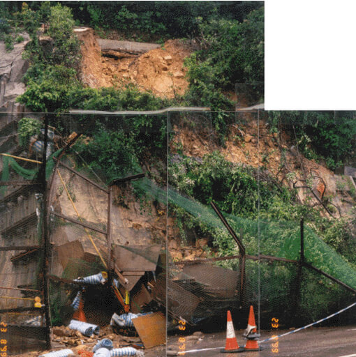
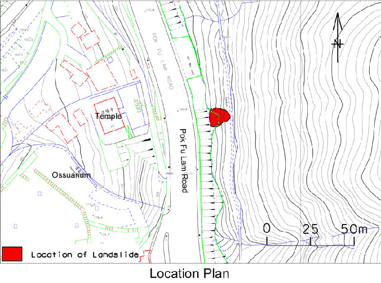
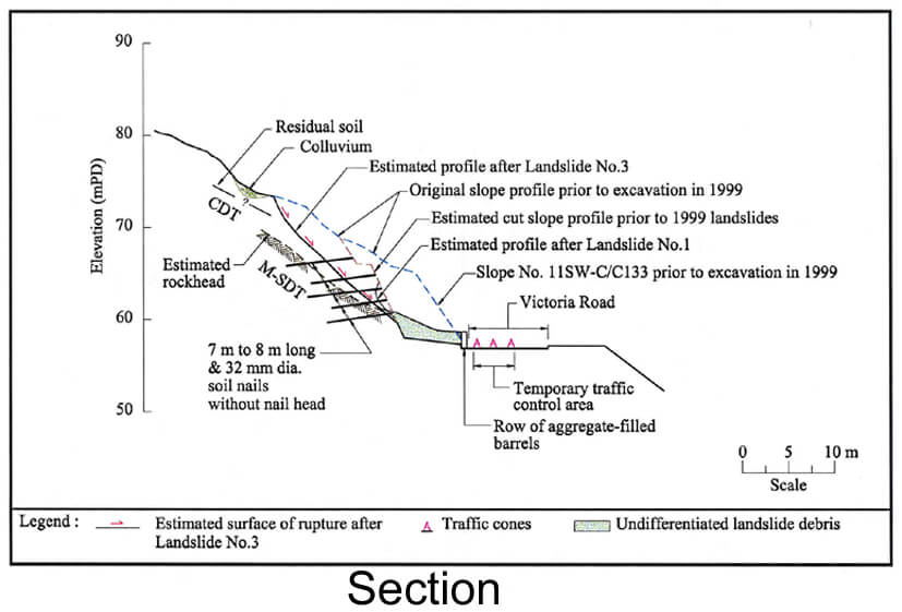
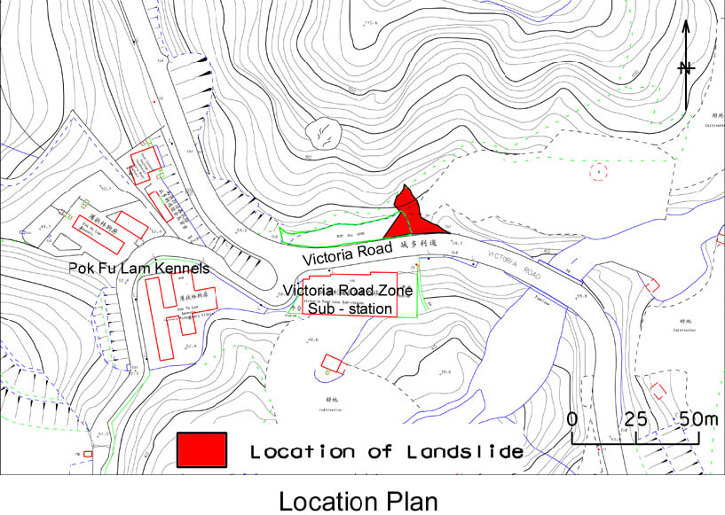
The 23 and 24 August 1999 Landslides at Victoria Road Opposite the Access Road to the Pok Fu Lam Kennels
Basic Data
Material:
Decomposed Volcanic Rocks
Feature Affected:
Cut Slope under Formation
Volume:
40 m3
Report Reference:
Initial Review of the 23 and 24 August 1999 Landslides at Victoria Road Opposite the Access Road to the Pok Fu Lam Kennels
Description
Three landslide incidents occurred at a 10 m high section of a cut slope where slope works were being carried out at the time of failure and soil nails had been installed (but with the nail head lattice structure yet to be constructed). Most of the debris was impeded by oil drums placed at the slope toe but outwash debris covered both lanes of Victoria Road. No fatalities or injuries were reported as a result of the landslides.
The rainfall that triggered the failures was moderate (estimated maximum return period of about 4 years). Contributory factors to the failures included blockage of surface water drainage provisions, inadequate surface protection against infiltration, presence of erosion pipes and open joints (exposed in the landslide scar). There were also adverse geological features (i.e. steep orthogonal relict joints forming the side release surfaces, a shallowly to moderately-inclined relict joint dipping out of the slope face forming the basal surface of rupture and the possible presence of a fault through the cut slope). The absence of structural nail heads at the time of the failure meant that the available capacity in the passive zone could not be fully mobilised because the capacity of the soil nail would have been limited by the active zone of the nail.
Observations
The incident highlights the importance of ensuring proper construction sequence and construction control, together with detailed engineering geological mapping and review of design assumptions during slope upgrading works.
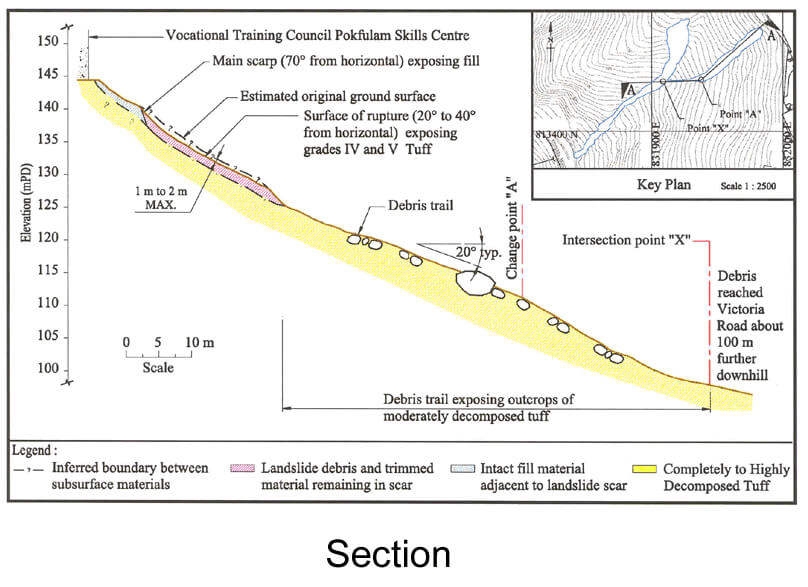
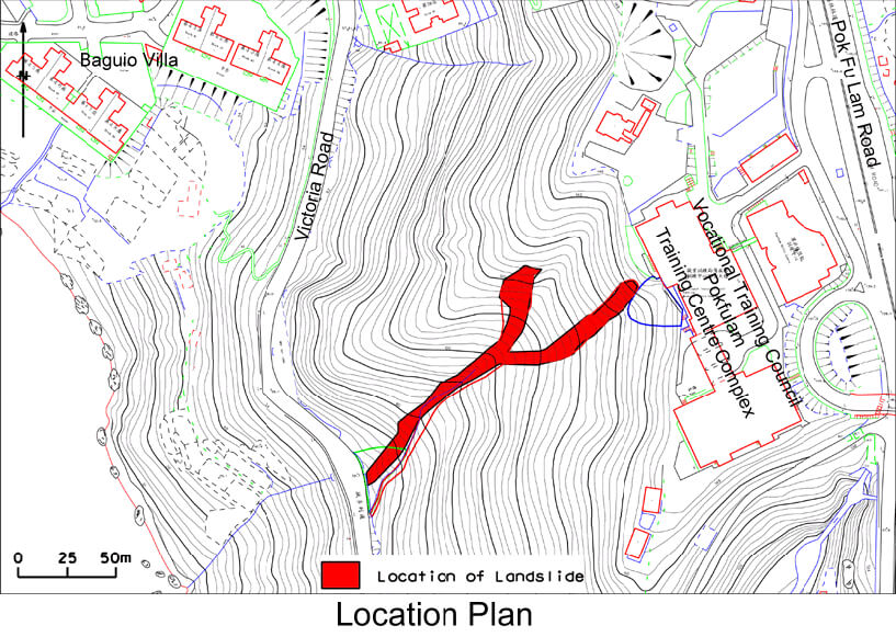
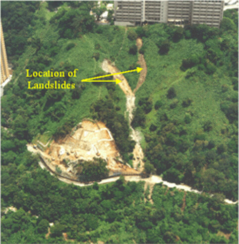
The 23 August 1999 Landslides below VTC Pokfulam Skills Centre, Pokfulam Road
Basic Data
Landslide A
Material:
Fill / Colluvium / Decomposed Volcanic Rocks
Feature Affected:
Unauthorized Fill Slope / Natural Slope
Volume:
100 m3 & 200 m3
Report Reference:
GEO Report No. 121
Description
Two landslides occurred within the same local catchment of the hillside, which has experienced a history of instability. One of the landslides (100 m3) involved unauthorized end-tipped fill while another (200 m3) involved natural terrain. Debris from both landslides became channelised in an ephemeral stream course and reached Victoria Road, with a travel angle of about 25°. Victoria Road was temporarily closed to traffic, but no casualties were reported.
The natural terrain failure occurred in an area with a possible break in slope with gully erosion in the vicinity. The locality showed evidence of progressive deterioration of the ground condition, in the form of localised tension cracking and ground movement.
Probable contributory factors to the failures were blockage of surface drainage provisions above one of the landslides, and the previous local instability resulting in changes in slope gradient and possible deterioration of ground conditions.
The landslides were probably caused by the build-up of transient elevated groundwater pressure in the soil mass following the rainstorm. The rainstorm that triggered the landslides was not particularly severe (estimated maximum return period of less than 2 years).
Observations
This incident highlights the hazard of unregistered fill on the natural hillside and the potential consequence of failures of natural hillsides (with developed areas at the crest and toe of the terrain).