The 9 June 1998 Landslide below Au Tau Village Road, Tseung Kwan O
Basic Data
Material:
Fill
Feature Affected:
Fill Slope No. 11NE-D/F284
Volume:
170 m3
Report Reference:
GEO Report No. 109
Description
The landslide involved the failure of an old fill slope below a minor road during severe rainfall (estimated return period of 18 years). The fill slope was formed by illegal dumping between 1976 and 1991. The open space within Tsui Lam Estate at the toe of the slope was temporarily closed to public following the landslide. No fatalities or injuries were reported as a result of the incident.
A notable change in the environmental conditions in the vicinity of the slope crest was the reconstruction of Au Tau Village Road pavement several months before the landslide. This included alteration of crossfalls of the road, with the result that overland flow from two natural stream courses became directed along the road surface towards the landslide site.
Overtopping of surface water from a road with substandard drainage provisions contributed to increased water ingress into the slope. Discharge from an 150 mm diameter, open-jointed PVC pipe of an unknown origin was also a contributory factor to the failure. This pipe has been cast into a Water Supplies Department (WSD) valve chamber that houses a 400 mm diameter watermain.
Observations
The incident highlights the hazard of illegal dumping of fill. It also emphasizes the fact that road surface maintenance works are liable to adversely influence the surface water flow paths through altering of cross-falls of carriageways. Due attention should be given to preventing overland flow onto vulnerable downhill slopes, particularly where loose fill is present.
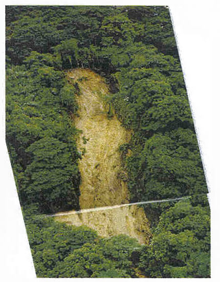
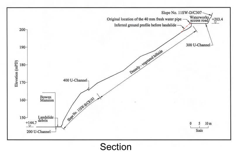
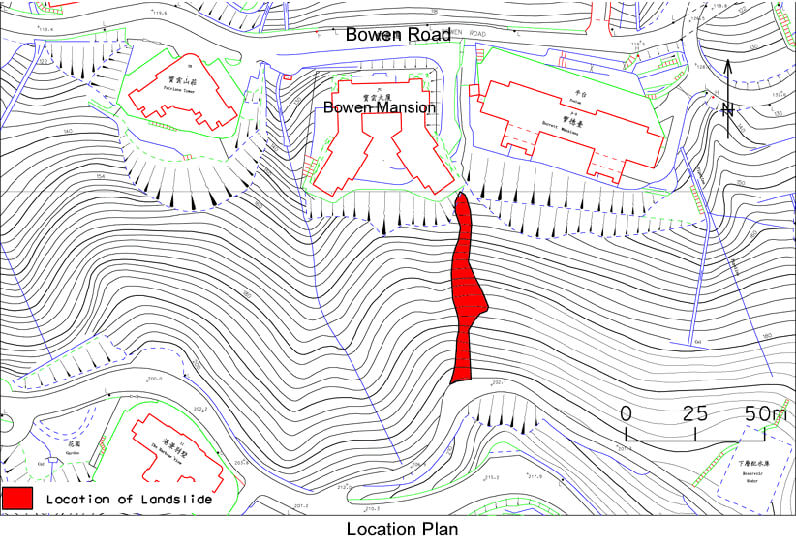
The 11 June 1998 Landslide behind 7C Bowen Road
Basic Data
Material:
Decomposed Volcanic Rocks
Feature Affected:
Natural Terrain
Volume:
10 m3
Report Reference:
GEO Report No. 112
Description
The landslide affected a portion of natural hillside that does not have any obvious evidence of past failures over the last several decades based on aerial photographs. The landslide debris travelled down the hillside and was deposited at the rear yard of a building at Bowen Road. There were no casualties caused by the landslide but some parts of the building suffered minor damage.
The rainfall preceding the landslide (estimated return period of 8 years), together with leakage from an exposed watermain along the access road above the crest of the hillside, probably contributed to the landslide. The detailing of the joints to the watermain near the crest of the landslide site is vulnerable to ground movement.
Observations
Watermains in close proximity to slopes (including natural hillsides) need attention in terms of regular inspection, maintenance and leakage detection. The above tasks are particularly important if there are developments below the slope. This incident illustrates the potential hazard of quasi-natural hillside failure which could be triggered by prolonged leakage or bursting of water-carrying services. Due attention should be given to the disposition and detailing of water-carrying services in close proximity to slopes.
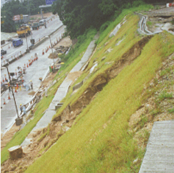
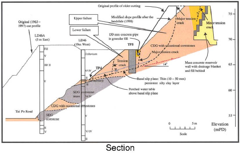
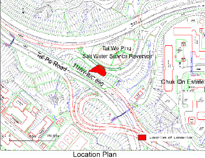
The 9 June 1998 Landslide at Tai Po Road near Chak On Estate
Basic Data
Material:
Decomposed Granite
Feature Affected:
Cut Slope No. 11NW-B/C60
Volume:
1,400 m3>
Report Reference:
GEO Report No. 113
Description
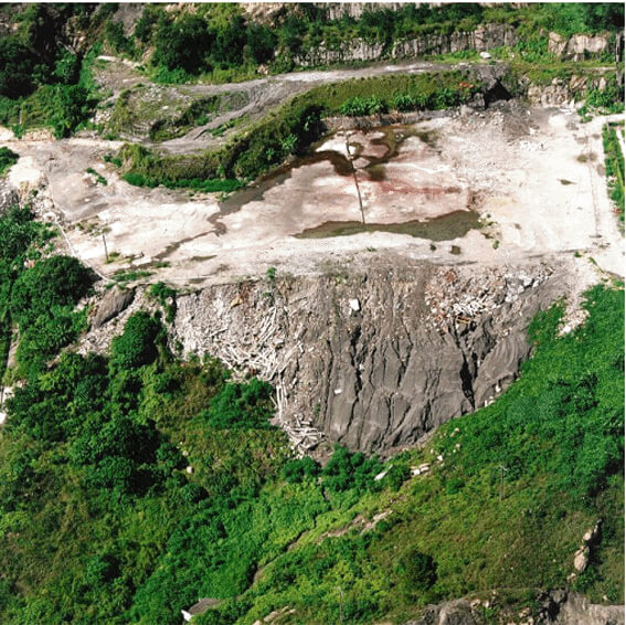
The landslide involved significant slope deformation, together with localised detachments, of a newly formed soil cut slope.
The landslide occurred about six months after the cut slope was built, i.e. in its first wet season. The rainfall that triggered the failure was moderately heavy (estimated return period of 10 years).
The failure was controlled at its base by an adversely orientated and gently dipping (about 14o), persistent sandy silty clay layer. Subvertical manganese coated, persistent discontinuities formed lateral release surfaces. These adverse geological structures were not considered in the original design, and were not identified during construction when the slope was cut back.
Inadequate maintenance of the old road (with severe cracking and potholes) above the slope crest and its drainage provisions probably promoted water ingress into the slope.
The slope design submission was only made to the Geotechnical Engineering Office (GEO) after the cutting had been formed. The design had not been accepted by the GEO when the failure occurred.
Observations
This incident highlights the importance of identification of adverse geological features during ground investigation and verification of the design geological model during slope works.
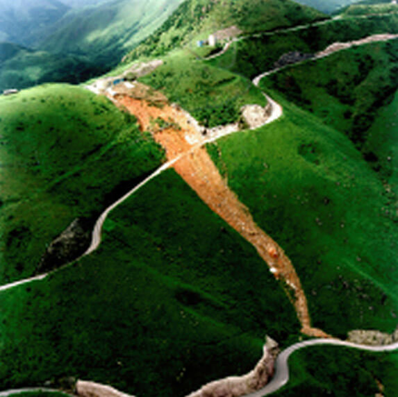
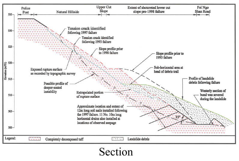
The 9 June 1998 Landslide at Tate's Ridge, Fei Ngo Shan Road
Basic Data
Material:
Decomposed Volcanic Rocks
Feature Affected:
Cut Slope No. 7SE-C/C42 and the hillside above
Volume:
2,500 m3
Report Reference:
GEO Report No. 113
Description
The subject cut slope has a history of failure since at least 1993. The mode of the previous failures involved slope movement, bulging and formation of tension cracks, but without major detachments. The slope toe was cut back in 1993, and soil nails and horizontal drains were installed in the lower slope portion in 1997 as urgent repair works. The slope and the failed ground above had not previously been assessed or designed to current geotechnical standards.
The 1998 landslide affected the upper part of the cut slope above the soil-nailed portion, together with the hillside above. The failure involved fast-moving debris. There is evidence that the previously observed tension cracks in the ground above the cut slope were not sealed properly. The debris from the 1998 landslide was more mobile than the past instabilities. The travel angle of the debris was about 30°.
The rainstorm which triggered the 1998 landslide was less severe than that experienced in the past when no significant detachment of debris occurred.
Observations
This landslide incident illustrates the following points:
Slope excavation at the toe of an unstable hillside will reduce the margin of safety against large-scale failures.
Signs of distress in the form of tension cracks could extend to a large distance above the crest of a cut slope where the development of a large-scale failure is involved. It is important that these are identified during site inspections and properly sealed against water ingress.
The slope and the hillside above have suffered prior significant movement and exhibited signs of distress. Given continued deterioration of the slope condition with the ground being gradually opened up further, slope instability may change from a 'ductile' mode to a 'brittle' (i.e. detachment) mode with fast-moving debris.
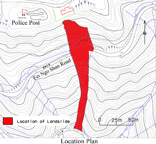
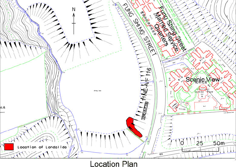
The 9 June 1998 Landslide at Fung Shing Street, Ngau Chi Wan
Basic Data
Material:
Fill
Feature Affected:
Fill Slope No. 11NE-A/F116
Volume:
250 m3
Report Reference:
GEO Report No. 114
Description
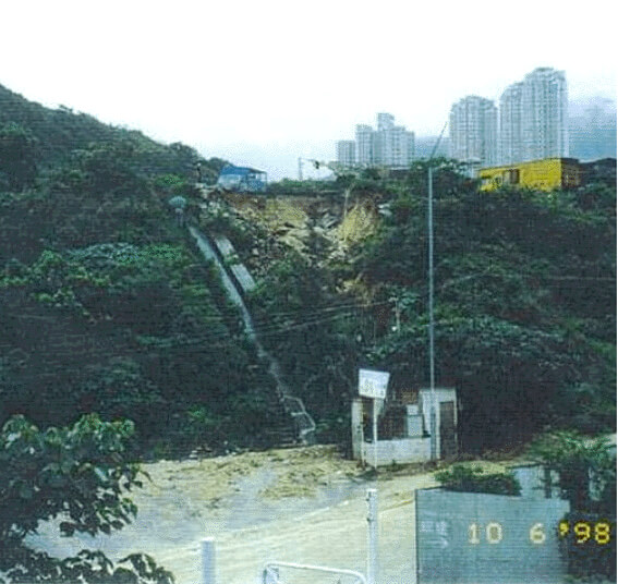
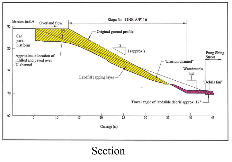
The landslide involved the failure of the capping layer to an old landfill slope, comprising domestic and commercial waste. The slope was formed before 1978. The landslide was probably caused by concentrated overland flow from the paved platform at the slope crest. The failure was triggered by severe rainfall (estimated return period of 40 years) and damaged a watchman's hut at the slope toe. No casualties resulted from the landslide. The surface water drainage provisions near the crest of the slope had been infilled and paved over prior to the failure and hence were no longer functional.
The slope has a history of past failures involving small slips and erosion. There is evidence that settlement of the landfill has occurred with time. This resulted in distress of the slope and could have adversely affected the surface flow regime of the paved platform above. At the time of the landslide, the responsibility for slope maintenance rests with the Short Term Tenancy (STT) tenant.
Observations
This incident provides an example of a major landslide where inadequate slope maintenance and inappropriate modifications to slope drainage provisions played a key role in causing the failure.
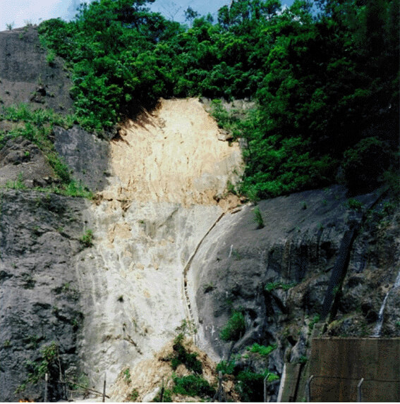
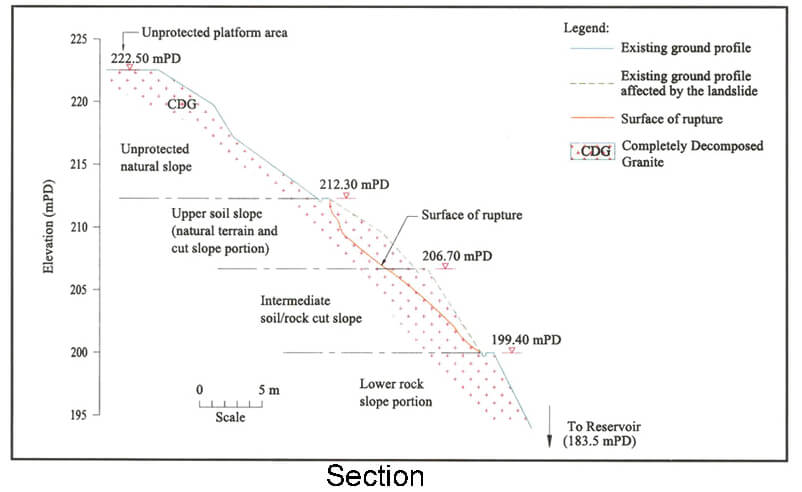
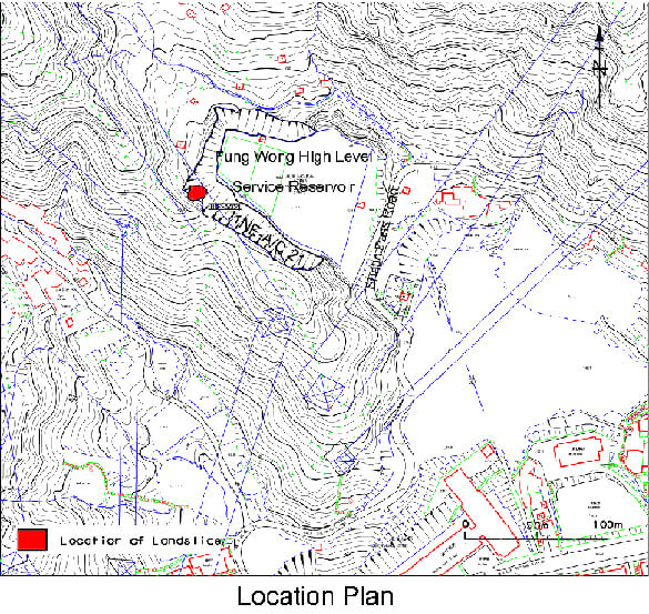
The 9 June 1998 Landslide at Fung Wong Reservoir, Shatin Pass
Basic Data
Material:
Decomposed Granite
Feature Affected:
Cut Slope No. 11NE-A/C21
Volume:
120 m3
Report Reference:
GEO Report No. 110
Description
The major landslide occurred on a vegetated cut slope during moderate rainstorms (estimated return period of 8 years) and resulted in the blockage of an access track at the slope toe. The landslide exploited kaolin and manganese infilled relict discontinuities. These weak discontinuities were not identified and considered in the previous slope assessment. The previous assessment concluded that no further action was warranted on the failed part of the cut slope although LPM action was taken on the rest of the slope.
There is a clustering of past failures in the immediate vicinity of the landslide site. This could be an indication of locally weak terrain and/or unfavourable groundwater conditions.
The structure-controlled failure was probably caused by the build-up of transient water pressure in the soil mass, particularly along relict discontinuities. Inadequate slope maintenance might also have been a contributory factor to the landslide.
Observations
The incident highlights the importance of characterising relict discontinuities and considering their effects in slope assessment and design. It also illustrates the importance of reviewing the adequacy of past assessments during Engineer Inspections.
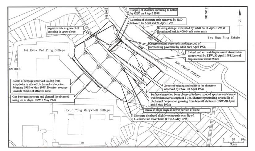
The 9 April 1998 Landslide at Hiu Kwong Street, Sau Mau Ping
Basic Data
Material:
Fill
Feature Affected:
Fill Slope No. 11NE-D/F10
Volume:
Distressed Ground > 1,000 m2
Report Reference:
GEO Report No. 109
Description
The incident involved a shotcreted fill slope exhibiting significant distress. The slope comprised a 3 m thick recompacted fill layer placed over the slope profile (with > 10 m of loose fill) in 1977. The slope was designed and checked to the required geotechnical standards in the late 1970's.
A major failure occurred in the slope in 1984. This was caused by leakage from a water main above the slope crest. The development of distress and intermittent movement since 1984 suggests that the slope was likely to have been disturbed to a greater extent than that covered by the remedial works to the 1984 failure. The previous remedial works comprised local replacement of disturbed material with compacted fill.
Prolonged seepage was observed from the slope in 1998. This was attributed to leakage from a saltwater main above the crest of the slope. The leakage had probably aggravated the slope condition.
There are several major water-carrying services (e.g. two pressurised fresh water mains and one pressurised saltwater main, and two stormwater drains and one foulwater sewer) at the crest of the slope. The fill slope is vulnerable to any leakage from these water-carrying services which are located within old fill.
Observations
The prescriptive approach of surface recompaction can be vulnerable to the effect of leakage from water-carrying services buried in old fill above the slope crest. This is especially so where there is a large depth of loose fill below the recompacted cap.
Care should be taken with the practice of placing compacted fill over the existing loose fill slope profile. This is because settlement could be induced which could adversely affect the compacted fill cap. If this were to happen, the integrity and permeability of the compacted fill could be compromised.
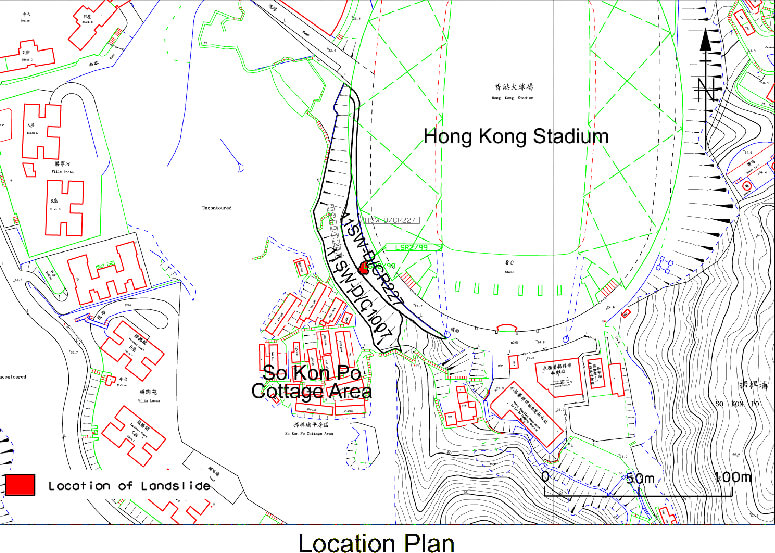
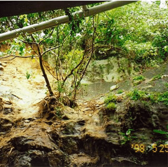
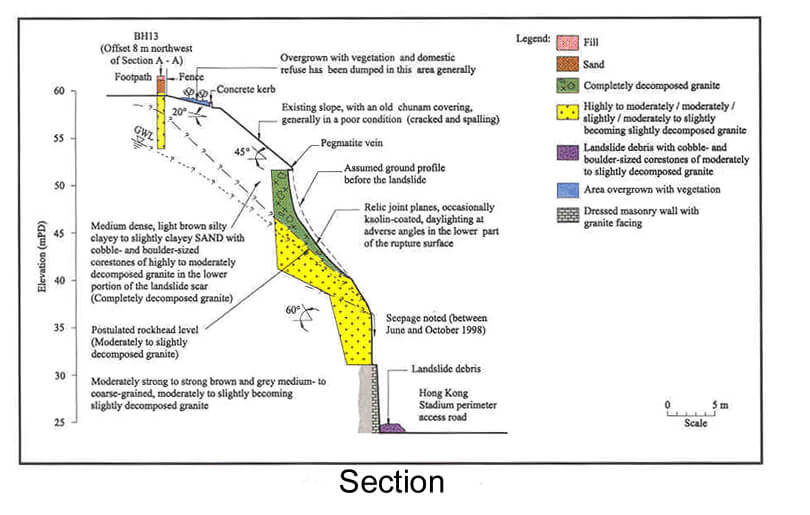
The 24 May 1998 Landslide at Hong Kong Stadium
Basic Data
Material:
Decomposed Granite
Feature Affected:
Cut Slopes Nos. 11SW-D/CR227 and 11SW-D/C1007
Volume:
5 m3
Report Reference:
GEO Report No. 111
Description
The landslide occurred in an oversteep (65o-75o) soil portion of a soil/rock cut slope. The failed area had a history of instabilities. The landslide debris partially blocked the perimeter access road of the Hong Kong Stadium. No casualties resulted from the landslide.
The slopes failed during a rainstorm (estimated return period of 5 years) that was less severe than previous rainstorms at the landslide site. This suggests that there may have been changes in environmental factors. Alternatively, the slope could have suffered progressive deterioration, possibly exacerbated by inadequate maintenance.
The failed slope was within the boundary of the Hong Kong Stadium redevelopment project in 1993. The design (involving cutting back) was accepted by the Geotechnical Engineering Office (GEO). However, the proposed upgrading works at the failed area were not carried out during construction as the consultant to the project considered (incorrectly) that this section of slope was in rock. No as-built drawings were submitted to the GEO on completion of slope upgrading works at the subject feature.
Observations
The incident highlights the importance of informing and agreeing with the GEO on any major changes in design as deemed necessary during the construction stage.
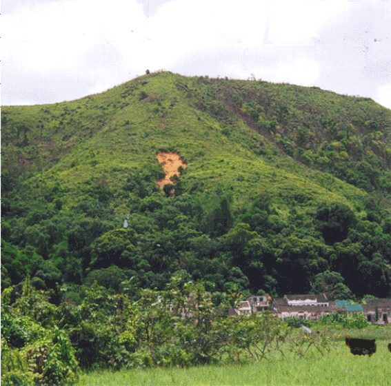
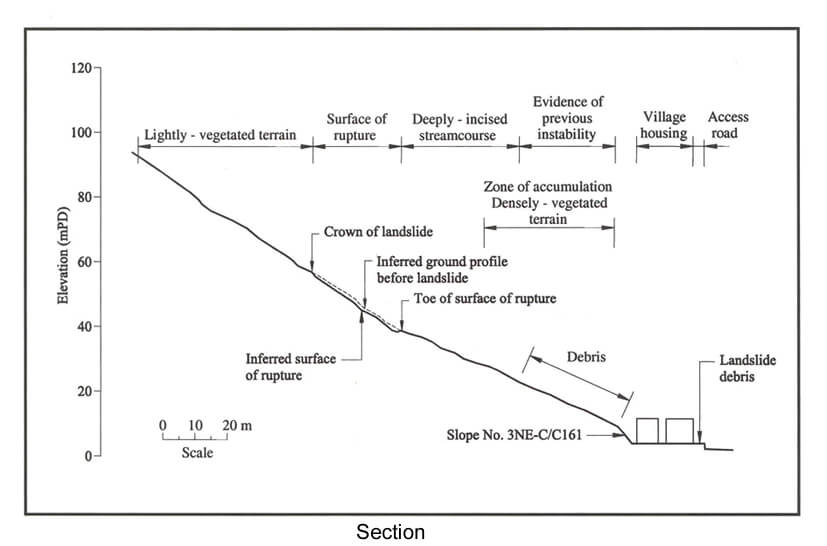
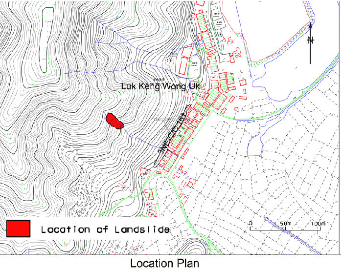
The 24 May 1998 Natural Terrain Landslide at Luk Keng Wong Uk, Luk Keng
Basic Data
Material:
Decomposed Siltstone
Feature Affected:
Natural Hillside
Volume:
150 m3
Report Reference:
GEO Report No. 108
Description
The landslide occurred on natural hillside, under moderately heavy rainfall (estimated return period of 8 years). The hillside has a history of failures. No casualties were reported as a result of the landslide.
The landslide debris travelled along a streamcourse as a channelised debris flow. The travel angle of the debris was about 23o and it affected the open areas of some dwellings within the village at the toe of the hillside. The village was previously subjected to a Non-Development Clearance (NDC) inspection. Some of the domestic houses are not classified as squatters and have not been recommended for clearance.
Observations
This incident highlights the need to continue to study natural terrain landslides, particularly where they impact on existing developments. This would lead to a better understanding of the diverse range and nature of natural hillside instability and assist in determining the appropriate follow-up actions.
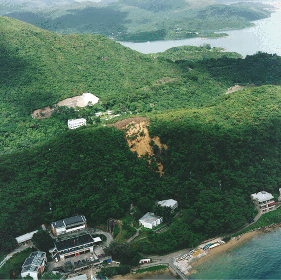
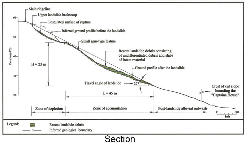
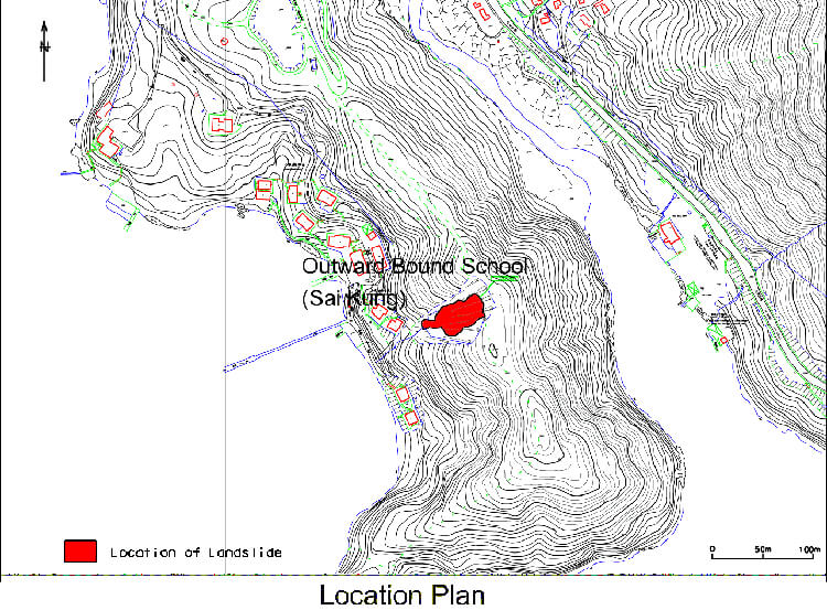
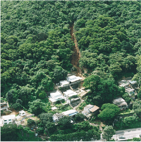
The 9 June 1998 Landslide at Natural Terrain at the Outward Bound School, Sai Kung
Basic Data
Material:
Colluvium / Decomposed Volcanic Rocks
Feature Affected:
Natural Terrain
Volume:
900 m3
Report Reference:
GEO Report No. 108
Description
The landslide was triggered by a severe rainstorm (estimated return period of about 70 years) and involved the failure of a natural hillside. The landslide debris was deposited within 20 m of a house which had to be temporarily evacuated for several months as a consequence.
The failure occurred in an area with a distinct break in slope. This area was likely to be the location of an old landslide scarp or scar. The failure probably involved a "retreating" hillside mechanism, i.e. successive discrete failures retrogressing uphill over a period of time.
The presence of deformed and cracked ground as well as open joints suggests that the hillside was only marginally stable and could have been subjected to progressive deterioration with time prior to the landslide. The presence of complex local geological and hydrogeological regimes (partly due to faults traversing the hillside) was a contributory factor to the landslide.
Observations
This incident illustrates the need to continue the study of natural terrain landslides to improve the understanding of the diverse range of hillside instability problems in Hong Kong.
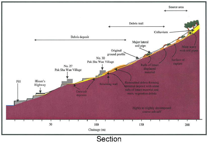
The 9 June 1998 Landslide at Natural Terrain above No. 30 Pak Sha Wan, Sai Kung
Basic Data
Material:
Colluvium / Decomposed Volcanic Rocks
Feature Affected:
Natural Terrain
Volume:
300 m3
Report Reference:
GEO Report No. 108
Description
The landslide occurred within a drainage line on a relatively gentle natural hillside (about 30°) with no evidence of past instability from the available aerial photographs. No casualties were reported as a result of the landslide.
More than one phase of landsliding was observed and the landsliding process took place over a period of about two hours. The wet landslide debris was relatively mobile, probably as a result of channelisation within the drainage line and the effects of surface water. The debris travelled downslope in the form of a channelised debris flow. The landslide debris affected the platforms formed for the village houses at the toe of the hillside.
The failure was probably caused by the development of transient elevated water pressures in the surface mantle of colluvium following a severe rainstorm (estimated return period of about 100 years). Concentrated surface and subsurface water flows, leading to water ingress into the landslide site, probably contributed to the failure.
Observations
The following observations can be made from this landslide incident :
Even gently inclined ground (i.e. about 30°) can be a source of a major landslide.
The lack of notable past failures from aerial photographs at this landslide site serves as a warning against over-reliance on the record or signs of past instability in natural terrain assessments.
Landslide debris can be quite mobile involving channelised debris flow due to the effect of surface water.

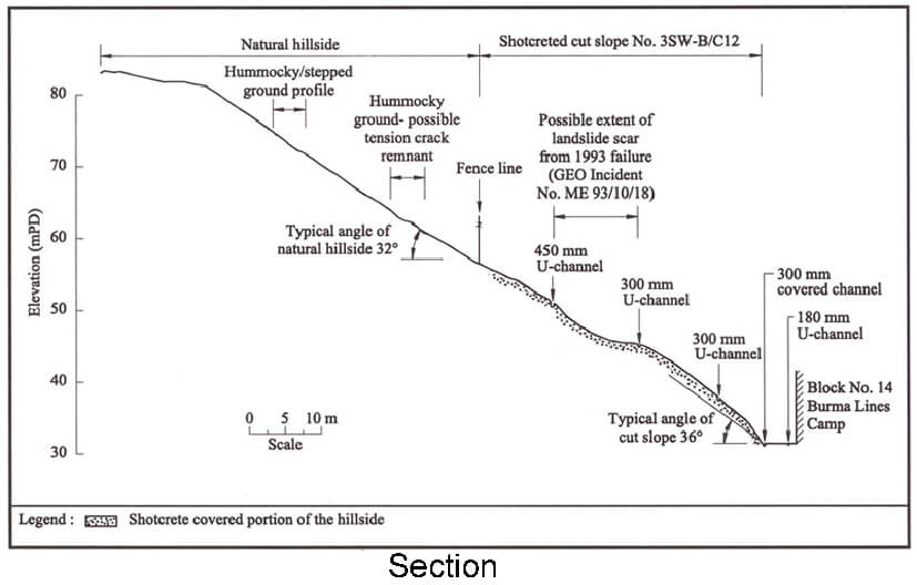
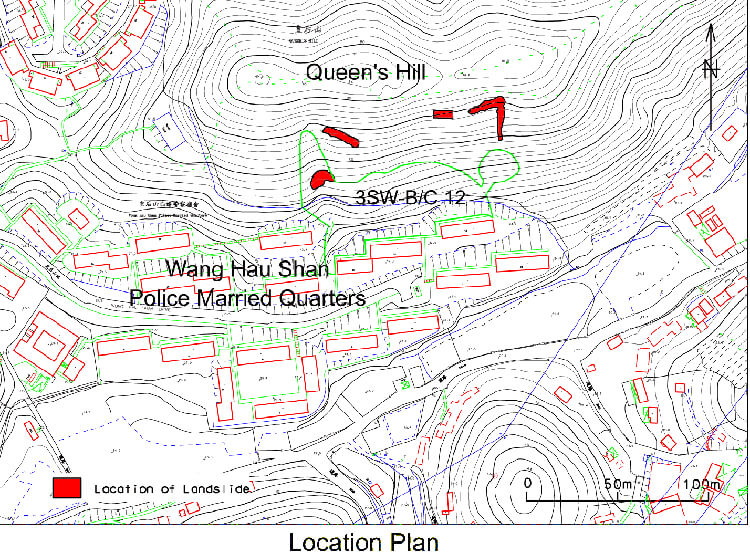
Slope Distress at Queen's Hill, Burma Lines Camp, Fanling
Basic Data
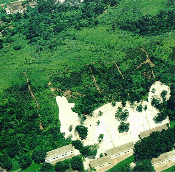
Material:
Colluvium / Decomposed Volcanic Rocks
Feature Affected:
Natural Hillside above Cut Slope No. 3SW-B/C12
Volume:
> 1,500 m3 Displaced
Report Reference:
GEO Report No. 112
Description
This incident involved extensive distress on a natural hillside. The distress predominantly involved slope movement, tension cracking and localised detachment. Some of the distress could be identified from aerial photographs dating back to 1924. The hillside instability was not identified during the detailed study of the cut slope at the toe of the hillside under the Landslip Preventive Measures (LPM) Programme in 1997. Not all the relevant aerial photographs were examined during the detailed study.
The identification of distress on the hillside has necessitated the evacuation of a number of dwellings at the toe of the hillside. Further vegetation clearance during the landslide study revealed more extensive distress which resulted in more dwellings having to be evacuated.
There is evidence over parts of the hillside that progressive ground movement and deterioration of the ground condition with time (e.g. cracking and opening up of the ground) could develop into more mobile failures.
Observations
The following observations can be made from this landslide incident :
The design engineer should be charged with the responsibility of ensuring that a comprehensive API report is prepared for the general area of the subject site. Detailed inspections of the site and its surrounding areas are also necessary to supplement the API.
Significant natural terrain landslides, particularly those close to developments, should be studied to improve the understanding of the diverse range of hillside instability problems.
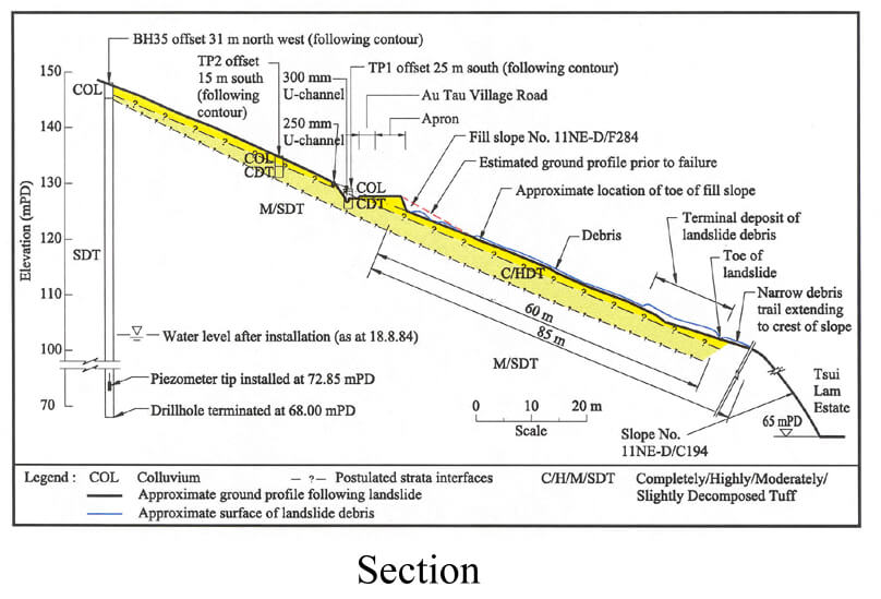
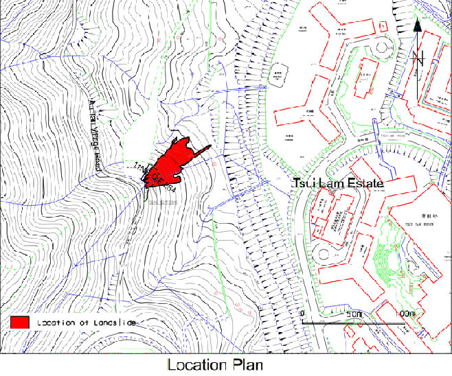
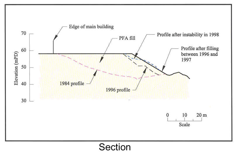
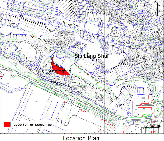
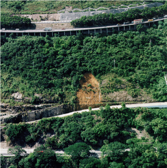
The 9 June 1998 Landslide at PFA Fill Slope at Siu Lang Shui, Tuen Mun
Basic Data
Material:
Fill
Feature Affected:
Fill Slope No. 5SE-D/F17
Volume:
1m000 m3
Report Reference:
GEO Report No. 109
Description
The landslide affected an unauthorized PFA fill slope on Government land. The failed slope was adjacent to an area leased to a tenant under a Short Term Tenancy (STT) Agreement between May 1984 and April 1998. The landslide occurred during a relatively moderate rainstorm (estimated return period of 6 years). Some of the landslide debris was washed down onto Lung Mun Road but the incident did not result in any casualties.
Unauthorized dumping of PFA fill was carried out by the tenant since 1985 to extend the platform beyond the STT boundary. The 1998 landslides involved fill that was dumped mainly between October 1996 and November 1997. The stability of this portion of the slope had not been assessed by the STT tenant.
The site above the failed slope was abandoned following termination of the STT in 1998. Inadequate drainage provisions, together with lack of maintenance, resulted in overland flow onto the loose fill slope. These adverse factors probably also contributed to causing the failure.
Observations
The incident emphasizes the hazard posed by illegal dumping of fill.
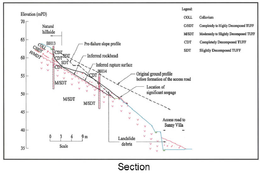
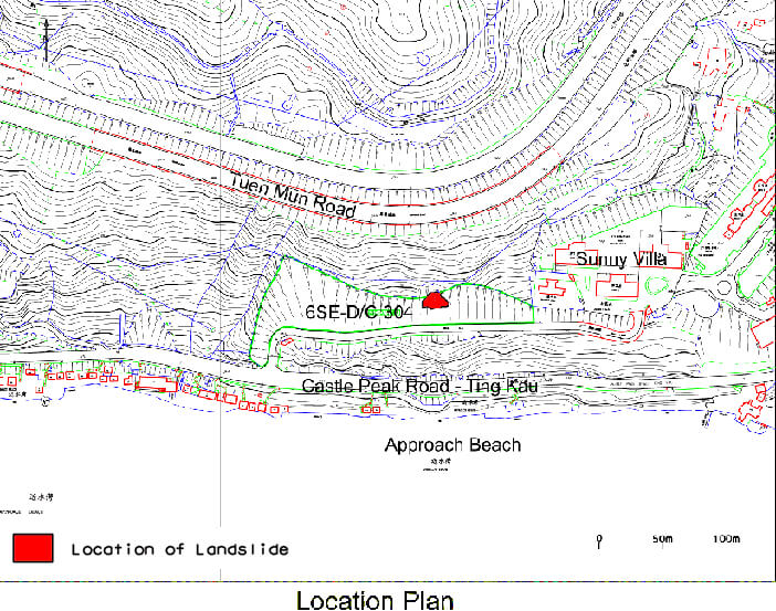
The 9 June 1998 Landslide at Sunny Villa, 218 Castle Peak Road
Basic Data
Material:
Colluvium / Decomposed Volcanic Rocks
Feature Affected:
Cut Slope No. 6SE-D/C304
Volume:
200 m3
Report Reference:
GEO Report No. 110
Description
The landslide occurred in the vegetated soil portion of a soil/rock cut slope and resulted in the total blockage of an access road to a private development. No casualties resulted from the failure. The slope was designed and checked to the required geotechnical standards in 1980.
The failure involved the development of elevated water pressure above the saprolite/Grade III interface. The presence of adversely orientated kaolin-infilled relict joints also contributed to the failure. Both of the above factors were not considered in the previous slope assessment.
The landslide occurred during a moderate rainstorm (estimated return period of 5 years) which was less severe than the past rainstorms at the site. The slope may have become more susceptible to instability with time (e.g. possible slope movement or distress during past severe rainstorms). Blocked crest drains due to inadequate maintenance leading to increased infiltration was also a significant contributory factor to the failure.
Observations
The following observations can be made from the landslide incident :
Reliance on performance history in past severe rainstorms for continued satisfactory slope performance should be done with extreme caution.
Engineering Inspections should look for any precursor signs of potential slope stability. This requirement applies also to post-GEO slopes. Adequate geological and hydrogeological characterisation of a slope is important. It is prudent to consider robustness in slope design to cater for possible adverse geological features and/or adverse groundwater conditions.
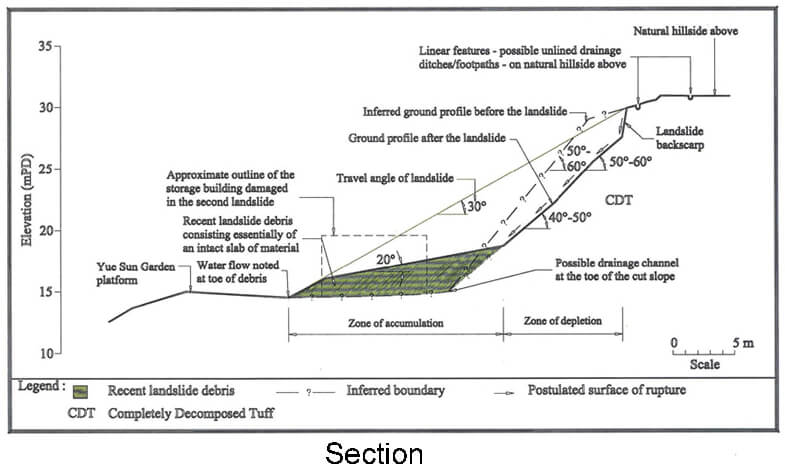
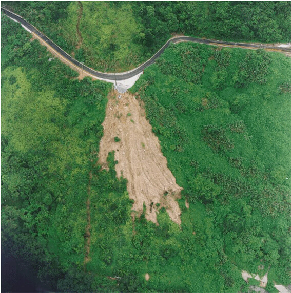
The 9 June 1998 Landslide at Yue Sun Garden, Wo Mei, Sai Kung
Basic Data

Material:
Fill / Decomposed Volcanic Rocks
Feature Affected:
Cut Slope No. 11NE-B/C513
Volume:
1,350 m3
Report Reference:
GEO Report No. 110
Description
The landslides occurred in an old cut slope under heavy rainfall (estimated return period of 35 years). The slope was formed before 1961 and had a history of instability based on aerial photographs. The landslide debris inundated the eastern half of the garden nursery below and an unoccupied storage building within the licensed area was damaged. No fatalities or injuries were reported as a result of the landslide.
The slope has not been maintained before the failure. Also, no repair works were carried out to the previous failures. Progressive deterioration of the slope condition was probably a major contributory factor to the failures.
The past failures were not included in landslide database of the Geotechnical Engineering Office (GEO) because they were not reported to the GEO.
Observations
This incident illustrates the importance of slope maintenance and the need to take past slope performance into account in slope assessments. The maintenance responsibility for a Government slope within and/or adjacent to a Short Term Tenancy (STT) site or a licenced area should be clearly assigned to the tenant or licensee under the tenancy/licensee conditions before leasing the land.